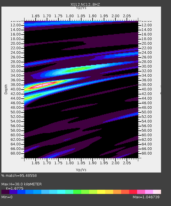
NC12 NC12 - Earthquake Result Viewer

Earthquake location: Near Coast Of Northern Chile
Earthquake latitude/longitude: -19.8/-70.9
Earthquake time(UTC): 2014/03/22 (081) 12:59:59 GMT
Earthquake Depth: 20 km
Earthquake Magnitude: 6.2 MWW, 6.2 MWB, 6.3 MWC, 6.4 MWC
Earthquake Catalog/Contributor: NEIC PDE/NEIC COMCAT
Network: XQ Pre-Hydrofracking Regional Assessment of Central Carolina Seismicity
Station: NC12 NC12
Lat/Lon: 35.38 N/79.24 W
Elevation: 136 m
Distance: 55.4 deg
Az: 351.694 deg
Baz: 170.415 deg
Ray Param: 0.06478371
Estimated Moho Depth: 38.0 km
Estimated Crust Vp/Vs: 1.68
Assumed Crust Vp: 6.565 km/s
Estimated Crust Vs: 3.913 km/s
Estimated Crust Poisson's Ratio: 0.22
Radial Match: 95.48558 %
Radial Bump: 266
Transverse Match: 80.03997 %
Transverse Bump: 400
SOD ConfigId: 3390531
Insert Time: 2019-04-10 19:53:28.354 +0000
GWidth: 2.5
Max Bumps: 400
Tol: 0.001

Signal To Noise

ChannelStoNSTALTA
XQ:NC12: :BHZ:20140322T13:09:01.619971Z2.2280193.200781E-71.436604E-7
XQ:NC12: :BHN:20140322T13:09:01.619971Z1.72141812.1562147E-71.2525804E-7
XQ:NC12: :BHE:20140322T13:09:01.619971Z1.3497281.8625039E-71.3799107E-7
Arrivals
Ps4.2 SECOND
PpPs15 SECOND
PsPs/PpSs19 SECOND