
Station XQ NC12 - NC12
Network: XQ12 - Pre-Hydrofracking Regional Assessment of Central Carolina Seismicity
Nearby stations (2 deg radius)
| Station | Name | (Lat, Lon) | Start / End | Elevation |
| NC12 | NC12 | (35.38, -79.24) | 2012-03-27 / 2014-12-31 | 136 m |
| Crust2 Type: | DG,thin Platform 1 km seds. |
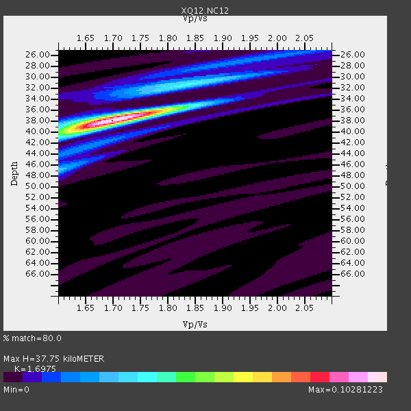
| Thickness Estimate: | 38 km |
| Thickness StdDev: | 0.3 km |
| Vp/Vs Estimate: | 1.70 |
| Vp/Vs StdDev: | 0.02 |
| Vs Estimate: | 3.867 km/s |
| Poisson's Ratio: | 0.23 |
| Peak Value: | 0.10 |
| Assumed Vp: | 6.565 km/s |
| Ps Weight: | 0.33333334 |
| PpPs Weight: | 0.33333334 |
| PsPs Weight: | 0.33333328 |
| Residual Complexity: | 0.375 |
| Nearby stations H: | +- |
| (2.0 deg) Vp/Vs: | +- |
2 with match > 90% ( 10.526316 %) and 4 with match > 80% ( 21.052631 %) out of 19.
Download stack as xyz text file.
Azimuth Distribution of Events:

Prior Results for this Station
| Study | Thickness | Vp/Vs | Vp | Vs | Poissons Ratio | Extra |
| EARS | 38 km | 1.70 | 6.565 km/s | 3.867 km/s | 0.23 | |
| Crust2.0 | 31 km | 1.78 | 6.565 km/s | 3.684 km/s | 0.27 | DG,thin Platform 1 km seds. |
| Global Maxima | 38 km | 1.70 | 6.565 km/s | 3.867 km/s | 0.23 | amp=0.10281223 |
| Local Maxima 1 | 31 km | 1.84 | 6.565 km/s | 3.563 km/s | 0.29 | amp=0.03400129 |
| Local Maxima 2 | 47 km | 1.60 | 6.565 km/s | 4.103 km/s | 0.18 | amp=0.026160436 |
| Local Maxima 3 | 36 km | 1.81 | 6.565 km/s | 3.632 km/s | 0.28 | amp=0.013518239 |
| Local Maxima 4 | 41 km | 1.61 | 6.565 km/s | 4.09 km/s | 0.18 | amp=0.0118333725 |
| Predicted Arrivals for vertical incidence (zero ray parameter) | |
| Ps | 4.01 SECOND |
| PpPs | 15.51 SECOND |
| PsPs/PpSs | 19.52 SECOND |
Events Processed for this Station
Download zip of receiver functions as SAC
Plot maxima for each earthquake.
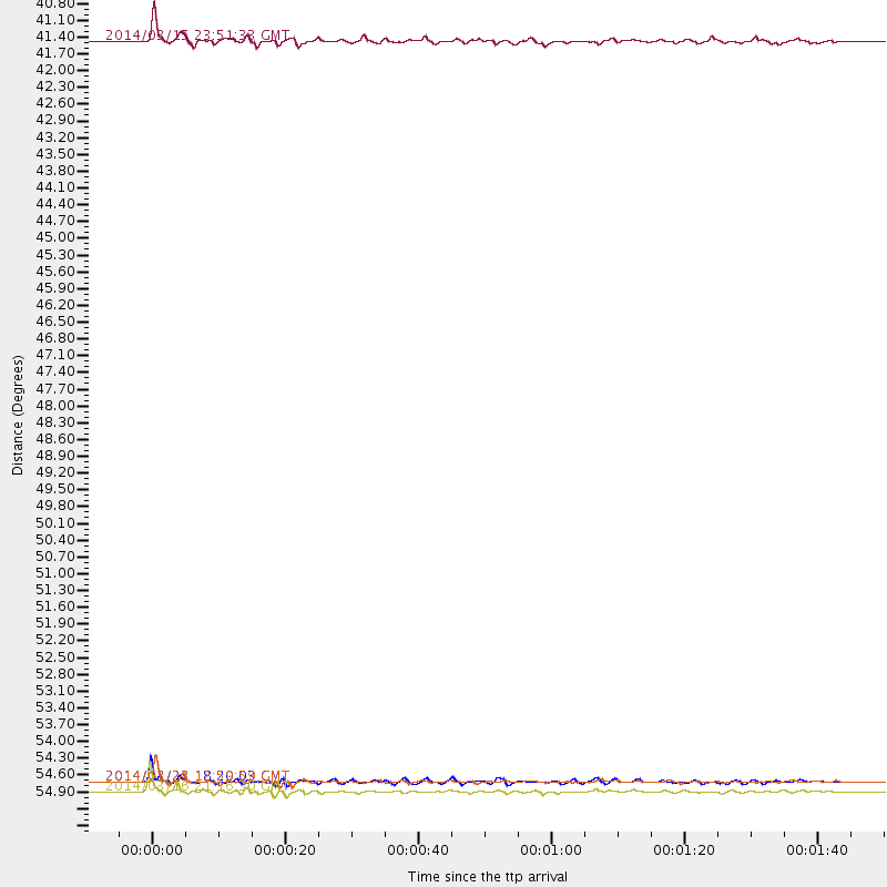
Events Used in the Stack
(4 events)| Radial Match | Distance | Baz | FERegion | Time | Lat/Lon | Depth | Magnitude |
| 97.28449 | 55.6 deg | 170.165 deg | Near Coast Of Northern Chile | 2014/03/16 21:16:30 GMT | (-19.9, -70.6) | 20 km | 6.7 MWW, 6.7 MWC, 7.0 MI |
| 95.48558 | 55.4 deg | 170.415 deg | Near Coast Of Northern Chile | 2014/03/22 12:59:59 GMT | (-19.8, -70.9) | 20 km | 6.2 MWW, 6.2 MWB, 6.3 MWC, 6.4 MWC |
| 89.557236 | 55.4 deg | 170.34 deg | Near Coast Of Northern Chile | 2014/03/23 18:20:03 GMT | (-19.7, -70.8) | 35 km | 6.0 MB, 6.2 MWB, 6.2 MWW, 6.3 MWC |
| 89.143654 | 40.8 deg | 182.611 deg | Near Coast Of Northern Peru | 2014/03/15 23:51:33 GMT | (-5.6, -81.0) | 29 km | 6.3 MWW, 6.2 MWB, 6.3 MWC |
Losers
(15 events)| Radial Match | Distance | Baz | FERegion | Time | Lat/Lon | Depth | Magnitude | Reason |
| 95.31945 | 36.2 deg | 292.68 deg | Off Coast Of Northern California | 2014/03/10 05:18:13 GMT | (40.8, -125.1) | 17 km | 6.8 MW, 6.8 MWR, 6.9 MWW, 6.9 MWB, 7.0 MI, 7.0 MWC | |
| 88.83893 | 30.8 deg | 174.93 deg | Colombia | 2014/01/05 03:36:40 GMT | (4.6, -76.6) | 54 km | 5.5 MWB, 5.6 MWC | |
| 81.582085 | 55.8 deg | 170.443 deg | Near Coast Of Northern Chile | 2014/03/18 14:35:58 GMT | (-20.1, -70.8) | 26 km | 5.1 MW | |
| 77.551414 | 49.4 deg | 175.345 deg | Near Coast Of Peru | 2014/02/18 23:35:58 GMT | (-14.2, -75.6) | 57 km | 6.0 MWB, 5.9 MWW, 5.9 MWC, 6.0 MWC | |
| 75.29465 | 49.3 deg | 176.242 deg | Near Coast Of Peru | 2014/03/15 08:59:21 GMT | (-14.1, -76.3) | 20 km | 6.1 MWW, 6.0 MWB, 6.2 MWC | |
| 65.78881 | 70.1 deg | 173.472 deg | Near Coast Of Central Chile | 2014/03/15 14:46:28 GMT | (-34.7, -71.8) | 45 km | 5.5 MB, 5.1 MWW | |
| 64.248085 | 55.3 deg | 170.322 deg | Near Coast Of Northern Chile | 2014/03/24 15:45:31 GMT | (-19.6, -70.8) | 18 km | 5.6 MWB, 5.5 MWR, 5.7 MWC, 5.7 MWW | |
| 63.75723 | 85.2 deg | 335.18 deg | Sakhalin, Russia | 2014/02/19 12:49:06 GMT | (52.2, 143.5) | 17 km | 4.9 MW | |
| 63.051117 | 69.0 deg | 318.376 deg | Andreanof Islands, Aleutian Is. | 2014/01/16 07:33:09 GMT | (51.2, -179.2) | 27 km | 5.5 MWB, 5.2 ML, 5.5 ML, 5.6 MWC | |
| 60.561035 | 75.7 deg | 53.24 deg | Greece | 2014/01/26 18:45:08 GMT | (38.2, 20.4) | 16 km | 5.4 MW | |
| 60.32263 | 56.3 deg | 162.526 deg | Southern Bolivia | 2014/01/27 16:42:37 GMT | (-19.3, -63.9) | 600 km | 5.6 MWB | |
| 60.04966 | 79.5 deg | 180.017 deg | Off Coast Of Southern Chile | 2014/01/07 12:06:13 GMT | (-44.5, -79.3) | 35 km | 5.2 MW | |
| 58.72522 | 32.4 deg | 173.811 deg | Colombia | 2014/01/09 12:50:16 GMT | (3.0, -75.9) | 15 km | 5.0 MW | |
| 57.3824 | 63.8 deg | 318.446 deg | Fox Islands, Aleutian Islands | 2014/02/26 21:13:40 GMT | (53.6, -171.8) | 265 km | 6.1 MWW, 5.9 MI, 5.9 ML, 6.1 MWC, 6.1 MWB, 6.2 MWC | |
| 52.15476 | 98.2 deg | 328.435 deg | Near East Coast Of Honshu, Japan | 2014/02/07 17:18:33 GMT | (37.5, 141.4) | 57 km | 5.0 MW |

