You are here: Home > Network List > Z910 - Southeastern Suture of the Appalachian Margin Experiment Stations List
> Station D12 Alewine Property, Royston, GA > Earthquake Result Viewer
D12 Alewine Property, Royston, GA - Earthquake Result Viewer
| Earthquake location: |
Near Coast Of Northern Chile |
| Earthquake latitude/longitude: |
-19.8/-70.9 |
| Earthquake time(UTC): |
2014/03/22 (081) 12:59:59 GMT |
| Earthquake Depth: |
20 km |
| Earthquake Magnitude: |
6.2 MWW, 6.2 MWB, 6.3 MWC, 6.4 MWC |
| Earthquake Catalog/Contributor: |
NEIC PDE/NEIC COMCAT |
|
| Network: |
Z9 Southeastern Suture of the Appalachian Margin Experiment |
| Station: |
D12 Alewine Property, Royston, GA |
| Lat/Lon: |
34.25 N/83.03 W |
| Elevation: |
247 m |
|
| Distance: |
54.9 deg |
| Az: |
347.693 deg |
| Baz: |
165.975 deg |
| Ray Param: |
0.065097995 |
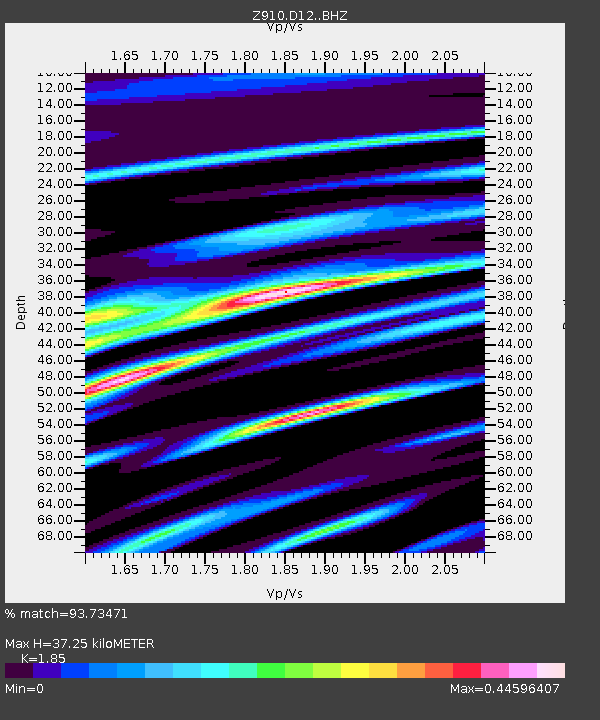
| Estimated Moho Depth: |
37.25 km |
| Estimated Crust Vp/Vs: |
1.85 |
| Assumed Crust Vp: |
6.35 km/s |
| Estimated Crust Vs: |
3.432 km/s |
| Estimated Crust Poisson's Ratio: |
0.29 |
|
| Radial Match: |
93.73471 % |
| Radial Bump: |
326 |
| Transverse Match: |
60.395374 % |
| Transverse Bump: |
400 |
| SOD ConfigId: |
3390531 |
| Insert Time: |
2019-04-10 19:54:57.847 +0000 |
| GWidth: |
2.5 |
| Max Bumps: |
400 |
| Tol: |
0.001 |
|

Signal To Noise
| Channel | StoN | STA | LTA |
| Z9:D12: :BHZ:20140322T13:08:58.180029Z | 3.9690175 | 5.278571E-7 | 1.3299439E-7 |
| Z9:D12: :BHN:20140322T13:08:58.180029Z | 3.0914235 | 2.8360876E-7 | 9.174051E-8 |
| Z9:D12: :BHE:20140322T13:08:58.180029Z | 1.1714008 | 1.4189693E-7 | 1.211344E-7 |
| Arrivals |
| Ps | 5.2 SECOND |
| PpPs | 16 SECOND |
| PsPs/PpSs | 21 SECOND |


