You are here: Home > Network List > Z910 - Southeastern Suture of the Appalachian Margin Experiment Stations List
> Station D20 Wells Property, Murphy, NC > Earthquake Result Viewer
D20 Wells Property, Murphy, NC - Earthquake Result Viewer
| Earthquake location: |
Near Coast Of Northern Chile |
| Earthquake latitude/longitude: |
-19.8/-70.9 |
| Earthquake time(UTC): |
2014/03/22 (081) 12:59:59 GMT |
| Earthquake Depth: |
20 km |
| Earthquake Magnitude: |
6.2 MWW, 6.2 MWB, 6.3 MWC, 6.4 MWC |
| Earthquake Catalog/Contributor: |
NEIC PDE/NEIC COMCAT |
|
| Network: |
Z9 Southeastern Suture of the Appalachian Margin Experiment |
| Station: |
D20 Wells Property, Murphy, NC |
| Lat/Lon: |
35.07 N/83.98 W |
| Elevation: |
478 m |
|
| Distance: |
55.9 deg |
| Az: |
347.026 deg |
| Baz: |
165.061 deg |
| Ray Param: |
0.064444475 |
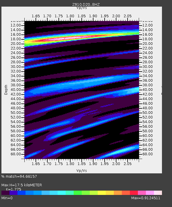
| Estimated Moho Depth: |
17.5 km |
| Estimated Crust Vp/Vs: |
1.77 |
| Assumed Crust Vp: |
6.35 km/s |
| Estimated Crust Vs: |
3.577 km/s |
| Estimated Crust Poisson's Ratio: |
0.27 |
|
| Radial Match: |
94.66157 % |
| Radial Bump: |
362 |
| Transverse Match: |
68.45769 % |
| Transverse Bump: |
400 |
| SOD ConfigId: |
3390531 |
| Insert Time: |
2019-04-10 19:55:02.622 +0000 |
| GWidth: |
2.5 |
| Max Bumps: |
400 |
| Tol: |
0.001 |
|

Signal To Noise
| Channel | StoN | STA | LTA |
| Z9:D20: :BHZ:20140322T13:09:05.319983Z | 5.77142 | 6.386253E-7 | 1.1065306E-7 |
| Z9:D20: :BHN:20140322T13:09:05.319983Z | 3.35553 | 3.3179074E-7 | 9.8878786E-8 |
| Z9:D20: :BHE:20140322T13:09:05.319983Z | 1.0802046 | 1.267031E-7 | 1.1729546E-7 |
| Arrivals |
| Ps | 2.2 SECOND |
| PpPs | 7.3 SECOND |
| PsPs/PpSs | 9.5 SECOND |


