
Station Z9 D20 - Wells Property, Murphy, NC
Network: Z910 - Southeastern Suture of the Appalachian Margin Experiment
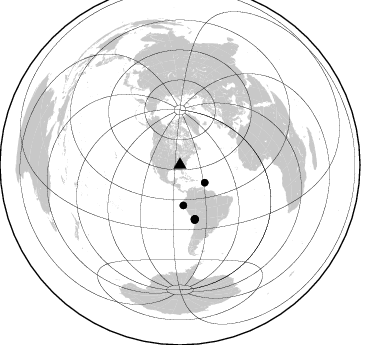
Nearby stations (2 deg radius)
| Station | Name | (Lat, Lon) | Start / End | Elevation |
| D20 | Wells Property, Murphy, NC | (35.07, -83.98) | 2012-05-10 / 2014-05-19 | 478 m |
| Crust2 Type: | P6,orogen/43km, Orogen, 0.5 km seds. |
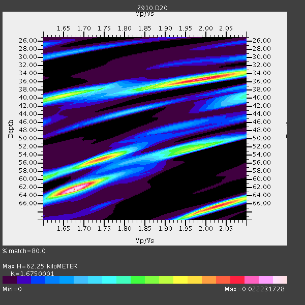
| Thickness Estimate: | 62 km |
| Thickness StdDev: | 11 km |
| Vp/Vs Estimate: | 1.68 |
| Vp/Vs StdDev: | 0.15 |
| Vs Estimate: | 3.791 km/s |
| Poisson's Ratio: | 0.22 |
| Peak Value: | 0.02 |
| Assumed Vp: | 6.35 km/s |
| Ps Weight: | 0.33333334 |
| PpPs Weight: | 0.33333334 |
| PsPs Weight: | 0.33333328 |
| Residual Complexity: | 0.856 |
| Nearby stations H: | +- |
| (2.0 deg) Vp/Vs: | +- |
4 with match > 90% ( 14.814815 %) and 7 with match > 80% ( 25.925926 %) out of 27.
Download stack as xyz text file.
Azimuth Distribution of Events:
Prior Results for this Station
| Study | Thickness | Vp/Vs | Vp | Vs | Poissons Ratio | Extra |
| EARS | 62 km | 1.68 | 6.35 km/s | 3.791 km/s | 0.22 | |
| Crust2.0 | 43 km | 1.76 | 6.35 km/s | 3.609 km/s | 0.26 | P6,orogen/43km, Orogen, 0.5 km seds. |
| Global Maxima | 62 km | 1.68 | 6.35 km/s | 3.791 km/s | 0.22 | amp=0.022231728 |
| Local Maxima 1 | 35 km | 1.98 | 6.35 km/s | 3.203 km/s | 0.33 | amp=0.019187996 |
| Local Maxima 2 | 66 km | 2.03 | 6.35 km/s | 3.124 km/s | 0.34 | amp=0.018097129 |
| Local Maxima 3 | 55 km | 1.73 | 6.35 km/s | 3.676 km/s | 0.25 | amp=0.013648805 |
| Local Maxima 4 | 52 km | 1.96 | 6.35 km/s | 3.24 km/s | 0.32 | amp=0.012112204 |
| Predicted Arrivals for vertical incidence (zero ray parameter) | |
| Ps | 6.62 SECOND |
| PpPs | 26.22 SECOND |
| PsPs/PpSs | 32.84 SECOND |
Events Processed for this Station
Download zip of receiver functions as SAC
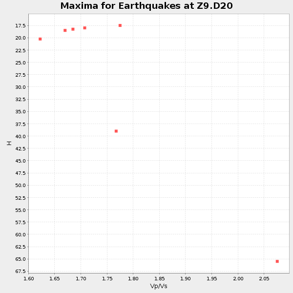
Plot maxima for each earthquake.
Events Used in the Stack
(7 events)| Radial Match | Distance | Baz | FERegion | Time | Lat/Lon | Depth | Magnitude |
| 94.66157 | 55.9 deg | 165.061 deg | Near Coast Of Northern Chile | 2014/03/22 12:59:59 GMT | (-19.8, -70.9) | 20 km | 6.2 MWW, 6.2 MWB, 6.3 MWC, 6.4 MWC |
| 90.974266 | 56.8 deg | 165.143 deg | Near Coast Of Northern Chile | 2014/04/04 01:37:51 GMT | (-20.6, -70.7) | 20 km | 6.1 MWP, 6.1 MWB, 6.1 MWW, 6.3 MWC |
| 90.87652 | 56.5 deg | 164.847 deg | Near Coast Of Northern Chile | 2014/04/03 01:58:31 GMT | (-20.3, -70.6) | 23 km | 6.5 MWW, 6.5 MWB, 6.6 MWC |
| 90.633545 | 56.1 deg | 164.832 deg | Near Coast Of Northern Chile | 2014/03/16 21:16:30 GMT | (-19.9, -70.6) | 20 km | 6.7 MWW, 6.7 MWC, 7.0 MI |
| 88.10259 | 40.5 deg | 175.366 deg | Near Coast Of Northern Peru | 2014/03/15 23:51:33 GMT | (-5.6, -81.0) | 29 km | 6.3 MWW, 6.2 MWB, 6.3 MWC |
| 87.46717 | 30.3 deg | 125.788 deg | North Atlantic Ocean | 2014/02/18 09:27:13 GMT | (14.7, -58.9) | 17 km | 6.5 MWW, 6.3 MWB, 6.5 MWC, 6.6 MWC, 6.7 MI |
| 83.74419 | 55.8 deg | 164.201 deg | Near Coast Of Northern Chile | 2014/04/01 23:59:57 GMT | (-19.5, -70.2) | 22 km | 5.8 MB |
Losers
(20 events)| Radial Match | Distance | Baz | FERegion | Time | Lat/Lon | Depth | Magnitude | Reason |
| 98.58242 | 55.8 deg | 164.965 deg | Near Coast Of Northern Chile | 2014/04/01 23:46:46 GMT | (-19.6, -70.8) | 20 km | 8.2 MWW, 8.0 MI, 8.1 MWC | |
| 95.63592 | 32.7 deg | 292.549 deg | Off Coast Of Northern California | 2014/03/10 05:18:13 GMT | (40.8, -125.1) | 17 km | 6.8 MW, 6.8 MWR, 6.9 MWW, 6.9 MWB, 7.0 MI, 7.0 MWC | |
| 95.326904 | 56.7 deg | 164.852 deg | Near Coast Of Northern Chile | 2014/04/03 02:43:14 GMT | (-20.5, -70.5) | 31 km | 7.7 MWW, 7.4 MI, 7.7 MWC | |
| 77.26474 | 57.0 deg | 164.816 deg | Near Coast Of Northern Chile | 2014/04/03 05:51:44 GMT | (-20.8, -70.4) | 27 km | 5.5 MB, 5.3 MWR | |
| 76.85375 | 55.8 deg | 165.078 deg | Near Coast Of Northern Chile | 2014/04/02 01:20:59 GMT | (-19.6, -70.9) | 22 km | 5.2 mb | |
| 72.57968 | 56.9 deg | 164.998 deg | Near Coast Of Northern Chile | 2014/04/03 02:56:06 GMT | (-20.7, -70.6) | 17 km | 5.6 MB | |
| 64.88371 | 66.5 deg | 316.911 deg | Andreanof Islands, Aleutian Is. | 2014/03/13 13:20:59 GMT | (51.2, -179.1) | 26 km | 5.6 MWC, 5.1 ML, 5.4 MWW, 5.4 MWB, 5.5 ML, 5.6 MWC | |
| 61.766117 | 49.6 deg | 169.305 deg | Near Coast Of Peru | 2014/02/18 23:35:58 GMT | (-14.2, -75.6) | 57 km | 6.0 MWB, 5.9 MWW, 5.9 MWC, 6.0 MWC | |
| 61.243702 | 83.7 deg | 332.811 deg | Sakhalin, Russia | 2014/02/19 12:49:06 GMT | (52.2, 143.5) | 17 km | 4.9 MW | |
| 60.99532 | 56.2 deg | 164.838 deg | Near Coast Of Northern Chile | 2014/04/02 00:37:49 GMT | (-20.0, -70.6) | 20 km | 5.4 mb | |
| 60.75376 | 55.9 deg | 164.985 deg | Near Coast Of Northern Chile | 2014/03/23 18:20:03 GMT | (-19.7, -70.8) | 35 km | 6.0 MB, 6.2 MWB, 6.2 MWW, 6.3 MWC | |
| 59.485134 | 61.5 deg | 317.321 deg | Fox Islands, Aleutian Islands | 2014/02/26 21:13:40 GMT | (53.6, -171.8) | 265 km | 6.1 MWW, 5.9 MI, 5.9 ML, 6.1 MWC, 6.1 MWB, 6.2 MWC | |
| 58.89615 | 64.5 deg | 211.066 deg | Easter Island Region | 2014/02/14 07:44:15 GMT | (-23.0, -114.3) | 12 km | 5.6 MWW, 5.5 MWB, 5.6 MWC | |
| 55.77999 | 68.5 deg | 168.793 deg | Near Coast Of Central Chile | 2014/04/05 02:22:38 GMT | (-32.8, -71.6) | 40 km | 5.6 MWC, 5.6 MWC | |
| 53.619682 | 55.5 deg | 164.819 deg | Near Coast Of Northern Chile | 2014/04/02 02:52:26 GMT | (-19.3, -70.8) | 17 km | 4.9 mb | |
| 53.49196 | 66.6 deg | 316.91 deg | Andreanof Islands, Aleutian Is. | 2014/01/16 07:33:09 GMT | (51.2, -179.2) | 27 km | 5.5 MWB, 5.2 ML, 5.5 ML, 5.6 MWC | |
| 52.240818 | 49.4 deg | 170.183 deg | Near Coast Of Peru | 2014/03/15 08:59:21 GMT | (-14.1, -76.3) | 20 km | 6.1 MWW, 6.0 MWB, 6.2 MWC | |
| 51.143497 | 80.8 deg | 174.478 deg | Off Coast Of Southern Chile | 2014/03/02 17:03:43 GMT | (-45.8, -76.2) | 10 km | 5.4 MW | |
| 50.440987 | 56.0 deg | 165.039 deg | Near Coast Of Northern Chile | 2014/03/23 20:23:04 GMT | (-19.9, -70.8) | 23 km | 5.3 MW | |
| 43.280766 | 44.5 deg | 212.313 deg | Central East Pacific Rise | 2014/01/07 23:02:53 GMT | (-4.5, -106.1) | 10 km | 5.7 MWB, 5.8 MWC |

