You are here: Home > Network List > Z910 - Southeastern Suture of the Appalachian Margin Experiment Stations List
> Station E02 St. Johns River Water District, Palatka, FL > Earthquake Result Viewer
E02 St. Johns River Water District, Palatka, FL - Earthquake Result Viewer
| Earthquake location: |
Near Coast Of Northern Chile |
| Earthquake latitude/longitude: |
-19.8/-70.9 |
| Earthquake time(UTC): |
2014/03/22 (081) 12:59:59 GMT |
| Earthquake Depth: |
20 km |
| Earthquake Magnitude: |
6.2 MWW, 6.2 MWB, 6.3 MWC, 6.4 MWC |
| Earthquake Catalog/Contributor: |
NEIC PDE/NEIC COMCAT |
|
| Network: |
Z9 Southeastern Suture of the Appalachian Margin Experiment |
| Station: |
E02 St. Johns River Water District, Palatka, FL |
| Lat/Lon: |
29.44 N/82.07 W |
| Elevation: |
21 m |
|
| Distance: |
50.1 deg |
| Az: |
347.248 deg |
| Baz: |
166.212 deg |
| Ray Param: |
0.06825714 |
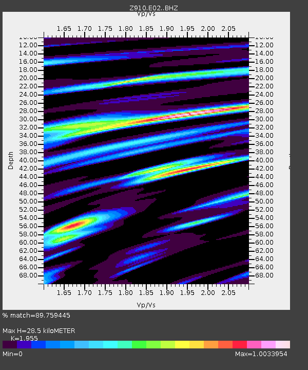
| Estimated Moho Depth: |
28.5 km |
| Estimated Crust Vp/Vs: |
1.96 |
| Assumed Crust Vp: |
5.989 km/s |
| Estimated Crust Vs: |
3.063 km/s |
| Estimated Crust Poisson's Ratio: |
0.32 |
|
| Radial Match: |
89.759445 % |
| Radial Bump: |
400 |
| Transverse Match: |
55.547012 % |
| Transverse Bump: |
400 |
| SOD ConfigId: |
3390531 |
| Insert Time: |
2019-04-10 19:55:04.354 +0000 |
| GWidth: |
2.5 |
| Max Bumps: |
400 |
| Tol: |
0.001 |
|

Signal To Noise
| Channel | StoN | STA | LTA |
| Z9:E02: :BHZ:20140322T13:08:22.340002Z | 1.2982208 | 3.6248267E-7 | 2.7921496E-7 |
| Z9:E02: :BHN:20140322T13:08:22.340002Z | 1.1256627 | 3.6434875E-7 | 3.236749E-7 |
| Z9:E02: :BHE:20140322T13:08:22.340002Z | 0.9829598 | 3.6358767E-7 | 3.6989067E-7 |
| Arrivals |
| Ps | 4.8 SECOND |
| PpPs | 13 SECOND |
| PsPs/PpSs | 18 SECOND |


