You are here: Home > Network List > IC - New China Digital Seismograph Network Stations List
> Station HIA Hailar, Neimenggu Autonomous Region, China > Earthquake Result Viewer
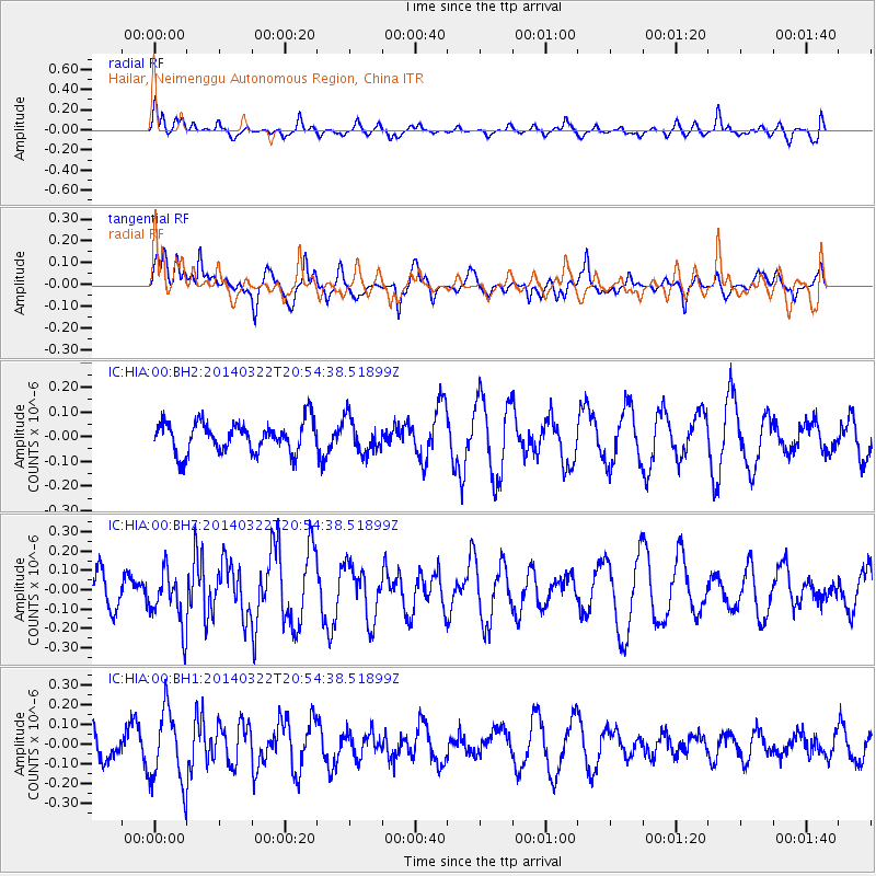
HIA Hailar, Neimenggu Autonomous Region, China - Earthquake Result Viewer
*The percent match for this event was below the threshold and hence no stack was calculated.
| Earthquake location: |
Talaud Islands, Indonesia |
| Earthquake latitude/longitude: |
3.6/127.1 |
| Earthquake time(UTC): |
2014/03/22 (081) 20:46:51 GMT |
| Earthquake Depth: |
54 km |
| Earthquake Magnitude: |
5.3 MW |
| Earthquake Catalog/Contributor: |
ISC/ISC |
|
| Network: |
IC New China Digital Seismograph Network |
| Station: |
HIA Hailar, Neimenggu Autonomous Region, China |
| Lat/Lon: |
49.27 N/119.74 E |
| Elevation: |
620 m |
|
| Distance: |
46.0 deg |
| Az: |
353.323 deg |
| Baz: |
169.794 deg |
| Ray Param: |
$rayparam |
*The percent match for this event was below the threshold and hence was not used in the summary stack. |
|
| Radial Match: |
45.758137 % |
| Radial Bump: |
399 |
| Transverse Match: |
69.26496 % |
| Transverse Bump: |
332 |
| SOD ConfigId: |
3390531 |
| Insert Time: |
2019-04-10 20:18:14.173 +0000 |
| GWidth: |
2.5 |
| Max Bumps: |
400 |
| Tol: |
0.001 |
|
Signal To Noise
| Channel | StoN | STA | LTA |
| IC:HIA:00:BHZ:20140322T20:54:38.51899Z | 1.9106108 | 1.412883E-7 | 7.394928E-8 |
| IC:HIA:00:BH1:20140322T20:54:38.51899Z | 1.8325158 | 1.879682E-7 | 1.0257385E-7 |
| IC:HIA:00:BH2:20140322T20:54:38.51899Z | 1.1177238 | 6.966568E-8 | 6.2328176E-8 |
| Arrivals |
| Ps | |
| PpPs | |
| PsPs/PpSs | |


