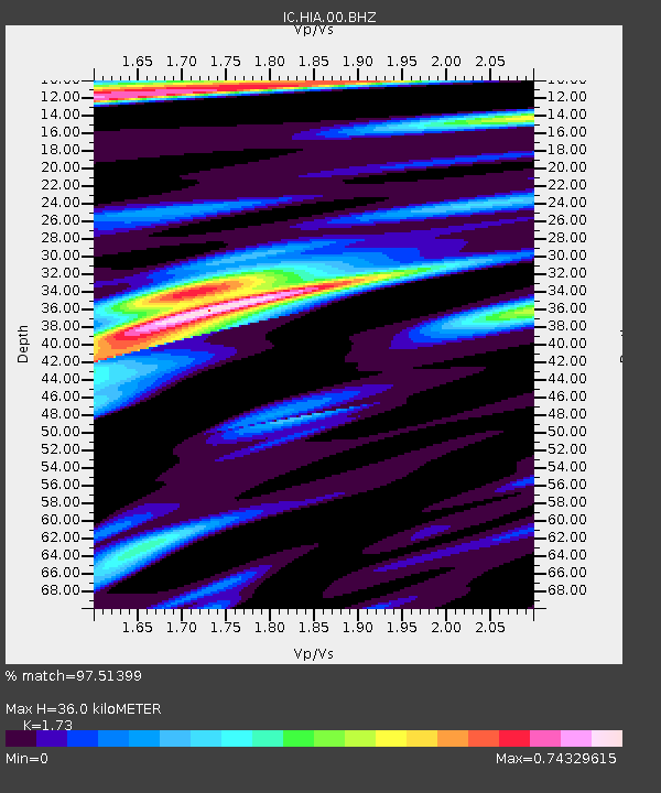
HIA Hailar, Neimenggu Province, China - Earthquake Result Viewer

Earthquake location: New Ireland Region, P.N.G.
Earthquake latitude/longitude: -3.2/150.6
Earthquake time(UTC): 2011/07/25 (206) 00:50:47 GMT
Earthquake Depth: 10 km
Earthquake Magnitude: 5.9 MB, 6.3 MS, 6.4 MW, 6.3 MW
Earthquake Catalog/Contributor: WHDF/NEIC
Network: IC New China Digital Seismograph Network
Station: HIA Hailar, Neimenggu Province, China
Lat/Lon: 49.27 N/119.74 E
Elevation: 620 m
Distance: 58.7 deg
Az: 336.836 deg
Baz: 143.156 deg
Ray Param: 0.06268139
Estimated Moho Depth: 36.0 km
Estimated Crust Vp/Vs: 1.73
Assumed Crust Vp: 6.577 km/s
Estimated Crust Vs: 3.802 km/s
Estimated Crust Poisson's Ratio: 0.25
Radial Match: 97.51399 %
Radial Bump: 346
Transverse Match: 86.52605 %
Transverse Bump: 400
SOD ConfigId: 405110
Insert Time: 2011-12-29 06:34:44.073 +0000
GWidth: 2.5
Max Bumps: 400
Tol: 0.001

Signal To Noise

ChannelStoNSTALTA
IC:HIA:00:BHZ:20110725T01:00:14.110996Z18.7554579.938869E-75.299188E-8
IC:HIA:00:BHN:20110725T01:00:14.110996Z5.2968042.8191513E-75.322363E-8
IC:HIA:00:BHE:20110725T01:00:14.110996Z5.2464312.2730057E-74.3324803E-8
Arrivals
Ps4.2 SECOND
PpPs14 SECOND
PsPs/PpSs18 SECOND