You are here: Home > Network List > Z910 - Southeastern Suture of the Appalachian Margin Experiment Stations List
> Station W20 Bledsoe Farm, Montezuma, GA > Earthquake Result Viewer
W20 Bledsoe Farm, Montezuma, GA - Earthquake Result Viewer
| Earthquake location: |
Near Coast Of Northern Chile |
| Earthquake latitude/longitude: |
-20.3/-70.6 |
| Earthquake time(UTC): |
2014/04/03 (093) 01:58:31 GMT |
| Earthquake Depth: |
23 km |
| Earthquake Magnitude: |
6.5 MWW, 6.5 MWB, 6.6 MWC |
| Earthquake Catalog/Contributor: |
NEIC PDE/NEIC COMCAT |
|
| Network: |
Z9 Southeastern Suture of the Appalachian Margin Experiment |
| Station: |
W20 Bledsoe Farm, Montezuma, GA |
| Lat/Lon: |
32.37 N/83.92 W |
| Elevation: |
134 m |
|
| Distance: |
53.9 deg |
| Az: |
345.986 deg |
| Baz: |
164.416 deg |
| Ray Param: |
0.065772355 |
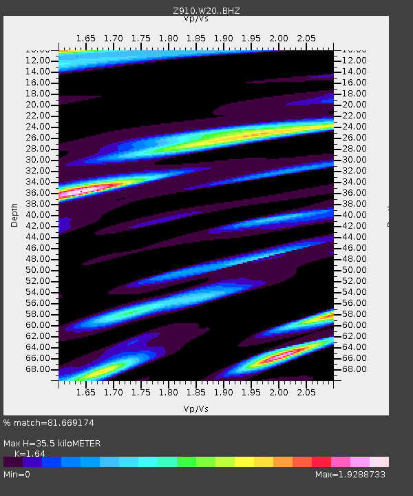
| Estimated Moho Depth: |
35.5 km |
| Estimated Crust Vp/Vs: |
1.64 |
| Assumed Crust Vp: |
6.565 km/s |
| Estimated Crust Vs: |
4.003 km/s |
| Estimated Crust Poisson's Ratio: |
0.20 |
|
| Radial Match: |
81.669174 % |
| Radial Bump: |
400 |
| Transverse Match: |
81.66918 % |
| Transverse Bump: |
400 |
| SOD ConfigId: |
3390531 |
| Insert Time: |
2019-04-11 02:06:11.907 +0000 |
| GWidth: |
2.5 |
| Max Bumps: |
400 |
| Tol: |
0.001 |
|

Signal To Noise
| Channel | StoN | STA | LTA |
| Z9:W20: :BHZ:20140403T02:07:21.940Z | 8.789031 | 9.5275766E-7 | 1.08403036E-7 |
| Z9:W20: :BHN:20140403T02:07:21.940Z | 1.6299319 | 5.2171924E-7 | 3.200865E-7 |
| $trig.getChannelId() | $trig.getValue() | $trig.getSTA() | $trig.getLTA() |
| Arrivals |
| Ps | 3.7 SECOND |
| PpPs | 13 SECOND |
| PsPs/PpSs | 17 SECOND |


