You are here: Home > Network List > Z910 - Southeastern Suture of the Appalachian Margin Experiment Stations List
> Station W31 Fort Yargo State Park, Winder, GA > Earthquake Result Viewer
W31 Fort Yargo State Park, Winder, GA - Earthquake Result Viewer
| Earthquake location: |
Near Coast Of Northern Chile |
| Earthquake latitude/longitude: |
-20.3/-70.6 |
| Earthquake time(UTC): |
2014/04/03 (093) 01:58:31 GMT |
| Earthquake Depth: |
23 km |
| Earthquake Magnitude: |
6.5 MWW, 6.5 MWB, 6.6 MWC |
| Earthquake Catalog/Contributor: |
NEIC PDE/NEIC COMCAT |
|
| Network: |
Z9 Southeastern Suture of the Appalachian Margin Experiment |
| Station: |
W31 Fort Yargo State Park, Winder, GA |
| Lat/Lon: |
33.97 N/83.74 W |
| Elevation: |
292 m |
|
| Distance: |
55.4 deg |
| Az: |
346.685 deg |
| Baz: |
164.92 deg |
| Ray Param: |
0.06479845 |
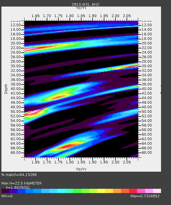
| Estimated Moho Depth: |
22.5 km |
| Estimated Crust Vp/Vs: |
1.60 |
| Assumed Crust Vp: |
6.565 km/s |
| Estimated Crust Vs: |
4.096 km/s |
| Estimated Crust Poisson's Ratio: |
0.18 |
|
| Radial Match: |
94.15298 % |
| Radial Bump: |
311 |
| Transverse Match: |
67.4905 % |
| Transverse Bump: |
400 |
| SOD ConfigId: |
3390531 |
| Insert Time: |
2019-04-11 02:06:20.071 +0000 |
| GWidth: |
2.5 |
| Max Bumps: |
400 |
| Tol: |
0.001 |
|

Signal To Noise
| Channel | StoN | STA | LTA |
| Z9:W31: :BHZ:20140403T02:07:32.820005Z | 5.976651 | 9.3952644E-7 | 1.5719947E-7 |
| Z9:W31: :BHN:20140403T02:07:32.820005Z | 4.5465817 | 4.5445512E-7 | 9.995534E-8 |
| Z9:W31: :BHE:20140403T02:07:32.820005Z | 1.363052 | 1.4790075E-7 | 1.0850704E-7 |
| Arrivals |
| Ps | 2.2 SECOND |
| PpPs | 8.4 SECOND |
| PsPs/PpSs | 11 SECOND |


