You are here: Home > Network List > OE - Austrian Seismic Network Stations List
> Station DAVA Damuels, Vorarlberg, Austria > Earthquake Result Viewer
DAVA Damuels, Vorarlberg, Austria - Earthquake Result Viewer
| Earthquake location: |
Near East Coast Of Honshu, Japan |
| Earthquake latitude/longitude: |
40.3/142.8 |
| Earthquake time(UTC): |
2011/09/16 (259) 19:26:40 GMT |
| Earthquake Depth: |
35 km |
| Earthquake Magnitude: |
6.0 MB, 6.5 MS, 6.7 MW, 6.7 MW |
| Earthquake Catalog/Contributor: |
WHDF/NEIC |
|
| Network: |
OE Austrian Seismic Network |
| Station: |
DAVA Damuels, Vorarlberg, Austria |
| Lat/Lon: |
47.29 N/9.88 E |
| Elevation: |
1602 m |
|
| Distance: |
83.3 deg |
| Az: |
329.857 deg |
| Baz: |
34.359 deg |
| Ray Param: |
0.046253674 |
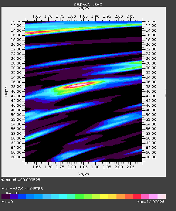
| Estimated Moho Depth: |
37.0 km |
| Estimated Crust Vp/Vs: |
1.83 |
| Assumed Crust Vp: |
6.416 km/s |
| Estimated Crust Vs: |
3.506 km/s |
| Estimated Crust Poisson's Ratio: |
0.29 |
|
| Radial Match: |
93.809525 % |
| Radial Bump: |
400 |
| Transverse Match: |
85.70797 % |
| Transverse Bump: |
400 |
| SOD ConfigId: |
414626 |
| Insert Time: |
2012-01-23 13:51:23.671 +0000 |
| GWidth: |
2.5 |
| Max Bumps: |
400 |
| Tol: |
0.001 |
|

Signal To Noise
| Channel | StoN | STA | LTA |
| OE:DAVA: :BHZ:20110916T19:38:32.90103Z | 7.9679856 | 7.749172E-7 | 9.725384E-8 |
| OE:DAVA: :BHN:20110916T19:38:32.90103Z | 2.590422 | 2.9260625E-7 | 1.12956975E-7 |
| OE:DAVA: :BHE:20110916T19:38:32.90103Z | 1.8604181 | 2.024217E-7 | 1.08804414E-7 |
| Arrivals |
| Ps | 4.9 SECOND |
| PpPs | 16 SECOND |
| PsPs/PpSs | 21 SECOND |


