You are here: Home > Network List > Z910 - Southeastern Suture of the Appalachian Margin Experiment Stations List
> Station W01 Suwannee River Water District, Perry, FL > Earthquake Result Viewer
W01 Suwannee River Water District, Perry, FL - Earthquake Result Viewer
| Earthquake location: |
E. Russia-N.E. China Border Reg. |
| Earthquake latitude/longitude: |
44.9/133.7 |
| Earthquake time(UTC): |
2014/04/12 (102) 21:22:44 GMT |
| Earthquake Depth: |
10 km |
| Earthquake Magnitude: |
4.3 mb |
| Earthquake Catalog/Contributor: |
ISC/ISC |
|
| Network: |
Z9 Southeastern Suture of the Appalachian Margin Experiment |
| Station: |
W01 Suwannee River Water District, Perry, FL |
| Lat/Lon: |
30.20 N/83.91 W |
| Elevation: |
12 m |
|
| Distance: |
97.8 deg |
| Az: |
32.222 deg |
| Baz: |
334.041 deg |
| Ray Param: |
0.040111784 |
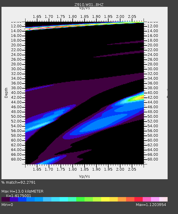
| Estimated Moho Depth: |
13.0 km |
| Estimated Crust Vp/Vs: |
1.62 |
| Assumed Crust Vp: |
6.565 km/s |
| Estimated Crust Vs: |
4.058 km/s |
| Estimated Crust Poisson's Ratio: |
0.19 |
|
| Radial Match: |
92.2791 % |
| Radial Bump: |
246 |
| Transverse Match: |
92.27908 % |
| Transverse Bump: |
246 |
| SOD ConfigId: |
3390531 |
| Insert Time: |
2019-04-11 08:23:01.892 +0000 |
| GWidth: |
2.5 |
| Max Bumps: |
400 |
| Tol: |
0.001 |
|

Signal To Noise
| Channel | StoN | STA | LTA |
| Z9:W01: :BHZ:20140412T21:35:48.05999Z | 2.156455 | 2.4703686E-5 | 1.1455693E-5 |
| $trig.getChannelId() | $trig.getValue() | $trig.getSTA() | $trig.getLTA() |
| Z9:W01: :BHE:20140412T21:35:48.05999Z | 1.4814132 | 3.4154327E-5 | 2.3055232E-5 |
| Arrivals |
| Ps | 1.3 SECOND |
| PpPs | 5.1 SECOND |
| PsPs/PpSs | 6.3 SECOND |


