
Station Z9 W01 - Suwannee River Water District, Perry, FL
Network: Z910 - Southeastern Suture of the Appalachian Margin Experiment
Nearby stations (2 deg radius)
| Station | Name | (Lat, Lon) | Start / End | Elevation |
| W01 | Suwannee River Water District, Perry, FL | (30.20, -83.91) | 2011-05-13 / 2014-05-15 | 12 m |
| Crust2 Type: | DG,thin Platform 1 km seds. |
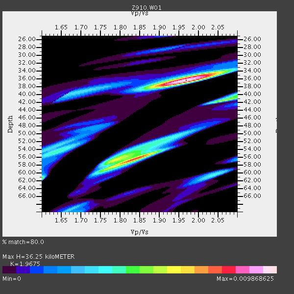
| Thickness Estimate: | 36 km |
| Thickness StdDev: | 9.9 km |
| Vp/Vs Estimate: | 1.97 |
| Vp/Vs StdDev: | 0.16 |
| Vs Estimate: | 3.336 km/s |
| Poisson's Ratio: | 0.33 |
| Peak Value: | 0.01 |
| Assumed Vp: | 6.565 km/s |
| Ps Weight: | 0.33333334 |
| PpPs Weight: | 0.33333334 |
| PsPs Weight: | 0.33333328 |
| Residual Complexity: | 0.731 |
| Nearby stations H: | +- |
| (2.0 deg) Vp/Vs: | +- |
2 with match > 90% ( 8.0 %) and 2 with match > 80% ( 8.0 %) out of 25.
Download stack as xyz text file.
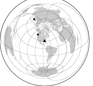
Azimuth Distribution of Events:
Prior Results for this Station
| Study | Thickness | Vp/Vs | Vp | Vs | Poissons Ratio | Extra |
| EARS | 36 km | 1.97 | 6.565 km/s | 3.336 km/s | 0.33 | |
| Crust2.0 | 31 km | 1.78 | 6.565 km/s | 3.684 km/s | 0.27 | DG,thin Platform 1 km seds. |
| Global Maxima | 36 km | 1.97 | 6.565 km/s | 3.336 km/s | 0.33 | amp=0.009868625 |
| Local Maxima 1 | 56 km | 1.84 | 6.565 km/s | 3.573 km/s | 0.29 | amp=0.008121807 |
| Local Maxima 2 | 41 km | 2.07 | 6.565 km/s | 3.175 km/s | 0.35 | amp=0.0057732905 |
| Local Maxima 3 | 54 km | 1.63 | 6.565 km/s | 4.015 km/s | 0.20 | amp=0.0042554094 |
| Local Maxima 4 | 56 km | 1.80 | 6.565 km/s | 3.657 km/s | 0.27 | amp=0.0041602817 |
| Predicted Arrivals for vertical incidence (zero ray parameter) | |
| Ps | 5.34 SECOND |
| PpPs | 16.39 SECOND |
| PsPs/PpSs | 21.73 SECOND |
Events Processed for this Station
Download zip of receiver functions as SAC
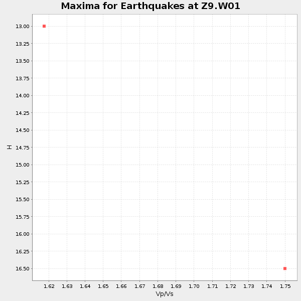
Plot maxima for each earthquake.
Events Used in the Stack
(2 events)| Radial Match | Distance | Baz | FERegion | Time | Lat/Lon | Depth | Magnitude |
| 92.2791 | 97.8 deg | 334.041 deg | E. Russia-N.E. China Border Reg. | 2014/04/12 21:22:44 GMT | (44.9, 133.7) | 10 km | 4.3 mb |
| 91.68499 | 38.0 deg | 313.628 deg | Vancouver Island, Canada Region | 2014/04/24 03:10:13 GMT | (49.8, -127.4) | 11 km | 6.7 MWP, 6.7 MI |
Losers
(23 events)| Radial Match | Distance | Baz | FERegion | Time | Lat/Lon | Depth | Magnitude | Reason |
| 91.08506 | 52.1 deg | 163.995 deg | Near Coast Of Northern Chile | 2014/04/03 02:43:14 GMT | (-20.5, -70.5) | 31 km | 7.7 MWW, 7.4 MI, 7.7 MWC | |
| 87.25327 | 34.9 deg | 299.084 deg | Off Coast Of Northern California | 2014/03/10 05:18:13 GMT | (40.8, -125.1) | 17 km | 6.8 MW, 6.8 MWR, 6.9 MWW, 6.9 MWB, 7.0 MI, 7.0 MWC | |
| 83.00216 | 51.8 deg | 163.981 deg | Near Coast Of Northern Chile | 2014/04/03 01:58:31 GMT | (-20.3, -70.6) | 23 km | 6.5 MWW, 6.5 MWB, 6.6 MWC | |
| 81.39771 | 51.5 deg | 163.954 deg | Near Coast Of Northern Chile | 2014/03/16 21:16:30 GMT | (-19.9, -70.6) | 20 km | 6.7 MWW, 6.7 MWC, 7.0 MI | |
| 76.86393 | 51.2 deg | 164.189 deg | Near Coast Of Northern Chile | 2014/03/22 12:59:59 GMT | (-19.8, -70.9) | 20 km | 6.2 MWW, 6.2 MWB, 6.3 MWC, 6.4 MWC | |
| 72.379524 | 52.1 deg | 164.305 deg | Near Coast Of Northern Chile | 2014/04/04 01:37:51 GMT | (-20.6, -70.7) | 20 km | 6.1 MWP, 6.1 MWB, 6.1 MWW, 6.3 MWC | |
| 65.57293 | 51.5 deg | 164.316 deg | Near Coast Of Northern Chile | 2014/04/19 20:54:42 GMT | (-20.0, -70.9) | 9.0 km | 5.8 MWR | |
| 62.883205 | 63.7 deg | 168.43 deg | Near Coast Of Central Chile | 2014/04/05 02:22:38 GMT | (-32.8, -71.6) | 40 km | 5.6 MWC, 5.6 MWC | |
| 62.361343 | 66.5 deg | 105.677 deg | Central Mid-Atlantic Ridge | 2014/03/29 07:46:50 GMT | (-0.8, -21.9) | 12 km | 5.9 MWW, 5.8 MWB, 6.0 MWC | |
| 59.59959 | 44.6 deg | 169.475 deg | Near Coast Of Peru | 2014/03/15 08:59:21 GMT | (-14.1, -76.3) | 20 km | 6.1 MWW, 6.0 MWB, 6.2 MWC | |
| 57.70301 | 44.8 deg | 168.531 deg | Near Coast Of Peru | 2014/02/18 23:35:58 GMT | (-14.2, -75.6) | 57 km | 6.0 MWB, 5.9 MWW, 5.9 MWC, 6.0 MWC | |
| 55.858196 | 52.0 deg | 164.248 deg | Near Coast Of Northern Chile | 2014/04/03 09:23:21 GMT | (-20.6, -70.7) | 15 km | 5.6 MB, 5.3 MWR | |
| 55.361374 | 51.6 deg | 164.287 deg | Near Coast Of Northern Chile | 2014/04/02 04:46:18 GMT | (-20.2, -70.9) | 10 km | 5.8 MB | |
| 54.517303 | 51.3 deg | 164.198 deg | Near Coast Of Northern Chile | 2014/03/22 13:14:55 GMT | (-19.8, -70.9) | 4.6 km | 5.2 Mww | |
| 53.27511 | 35.7 deg | 174.955 deg | Near Coast Of Northern Peru | 2014/03/15 23:51:33 GMT | (-5.6, -81.0) | 29 km | 6.3 MWW, 6.2 MWB, 6.3 MWC | |
| 53.099777 | 51.1 deg | 164.083 deg | Near Coast Of Northern Chile | 2014/04/01 23:46:46 GMT | (-19.6, -70.8) | 20 km | 8.2 MWW, 8.0 MI, 8.1 MWC | |
| 52.47003 | 65.1 deg | 318.968 deg | Fox Islands, Aleutian Islands | 2014/02/26 21:13:40 GMT | (53.6, -171.8) | 265 km | 6.1 MWW, 5.9 MI, 5.9 ML, 6.1 MWC, 6.1 MWB, 6.2 MWC | |
| 52.39703 | 51.9 deg | 164.498 deg | Near Coast Of Northern Chile | 2014/04/06 14:06:09 GMT | (-20.4, -71.0) | 20 km | 5.3 MW | |
| 47.5668 | 84.4 deg | 199.382 deg | Southern East Pacific Rise | 2014/05/12 18:38:37 GMT | (-50.0, -114.7) | 8.2 km | 5.8 MB | |
| 39.767975 | 67.2 deg | 191.173 deg | West Chile Rise | 2014/05/06 20:52:29 GMT | (-36.3, -96.7) | 14 km | 5.9 MWB | |
| 36.59884 | 53.6 deg | 324.547 deg | Southern Alaska | 2014/05/10 14:16:08 GMT | (60.0, -152.2) | 96 km | 5.8 ML, 5.5 MI, 5.7 MWP | |
| 35.418365 | 51.1 deg | 164.069 deg | Near Coast Of Northern Chile | 2014/04/02 00:06:44 GMT | (-19.6, -70.8) | 10 km | 5.7 MB | |
| 30.300669 | 51.2 deg | 163.695 deg | Near Coast Of Northern Chile | 2014/04/02 00:04:54 GMT | (-19.6, -70.5) | 34 km | 5.5 MB |

