You are here: Home > Network List > IC - New China Digital Seismograph Network Stations List
> Station HIA Hailar, Neimenggu Province, China > Earthquake Result Viewer
HIA Hailar, Neimenggu Province, China - Earthquake Result Viewer
*The percent match for this event was below the threshold and hence no stack was calculated.
| Earthquake location: |
New Britain Region, P.N.G. |
| Earthquake latitude/longitude: |
-5.8/151.0 |
| Earthquake time(UTC): |
2011/10/18 (291) 05:05:06 GMT |
| Earthquake Depth: |
26 km |
| Earthquake Magnitude: |
5.5 MB, 5.9 MS, 6.0 MW, 6.1 MW |
| Earthquake Catalog/Contributor: |
WHDF/NEIC |
|
| Network: |
IC New China Digital Seismograph Network |
| Station: |
HIA Hailar, Neimenggu Province, China |
| Lat/Lon: |
49.27 N/119.74 E |
| Elevation: |
620 m |
|
| Distance: |
61.2 deg |
| Az: |
337.161 deg |
| Baz: |
143.871 deg |
| Ray Param: |
$rayparam |
*The percent match for this event was below the threshold and hence was not used in the summary stack. |
|
| Radial Match: |
68.672874 % |
| Radial Bump: |
400 |
| Transverse Match: |
71.281654 % |
| Transverse Bump: |
397 |
| SOD ConfigId: |
424168 |
| Insert Time: |
2012-02-10 00:39:42.092 +0000 |
| GWidth: |
2.5 |
| Max Bumps: |
400 |
| Tol: |
0.001 |
|
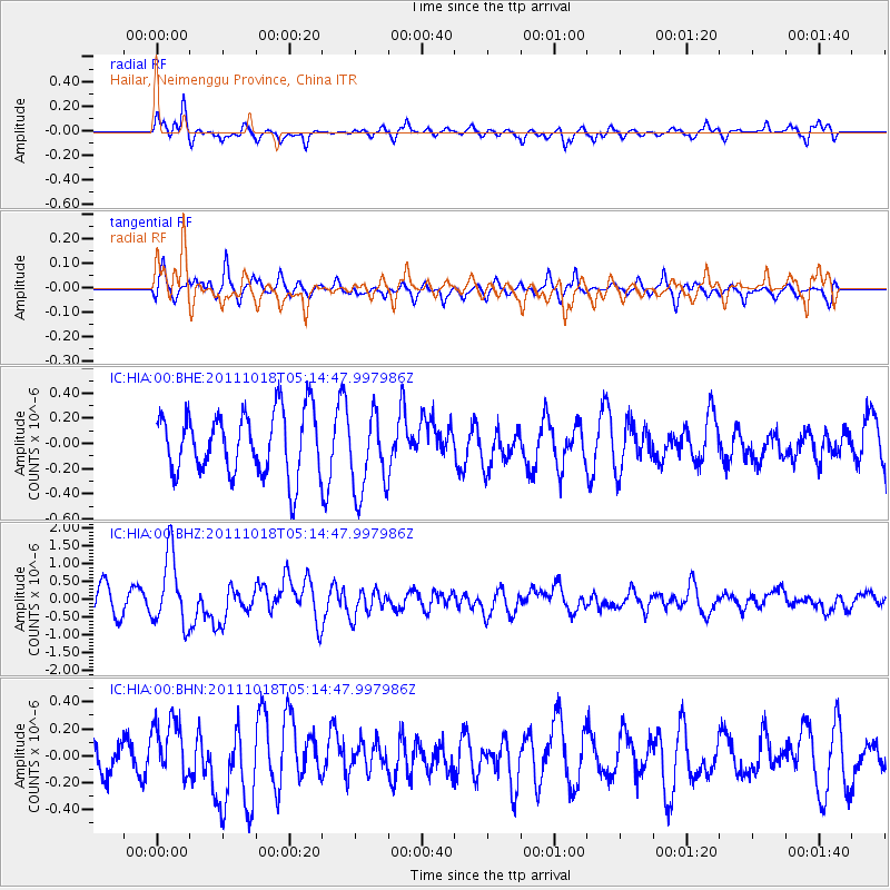
Signal To Noise
| Channel | StoN | STA | LTA |
| IC:HIA:00:BHZ:20111018T05:14:47.997986Z | 2.9591498 | 1.0040626E-6 | 3.3930777E-7 |
| IC:HIA:00:BHN:20111018T05:14:47.997986Z | 1.7942026 | 2.176948E-7 | 1.2133235E-7 |
| IC:HIA:00:BHE:20111018T05:14:47.997986Z | 1.2945814 | 3.2146497E-7 | 2.4831576E-7 |
| Arrivals |
| Ps | |
| PpPs | |
| PsPs/PpSs | |


