You are here: Home > Network List > GS - US Geological Survey Networks Stations List
> Station SPFD Fire Department, Spotsylvania, VA 22551 USA > Earthquake Result Viewer
SPFD Fire Department, Spotsylvania, VA 22551 USA - Earthquake Result Viewer
| Earthquake location: |
Turkey |
| Earthquake latitude/longitude: |
38.7/43.5 |
| Earthquake time(UTC): |
2011/10/23 (296) 10:41:22 GMT |
| Earthquake Depth: |
16 km |
| Earthquake Magnitude: |
6.9 MB, 7.3 MS, 7.3 MW, 7.1 MW |
| Earthquake Catalog/Contributor: |
WHDF/NEIC |
|
| Network: |
GS US Geological Survey Networks |
| Station: |
SPFD Fire Department, Spotsylvania, VA 22551 USA |
| Lat/Lon: |
38.14 N/77.52 W |
| Elevation: |
79 m |
|
| Distance: |
86.3 deg |
| Az: |
317.381 deg |
| Baz: |
42.198 deg |
| Ray Param: |
0.044162653 |
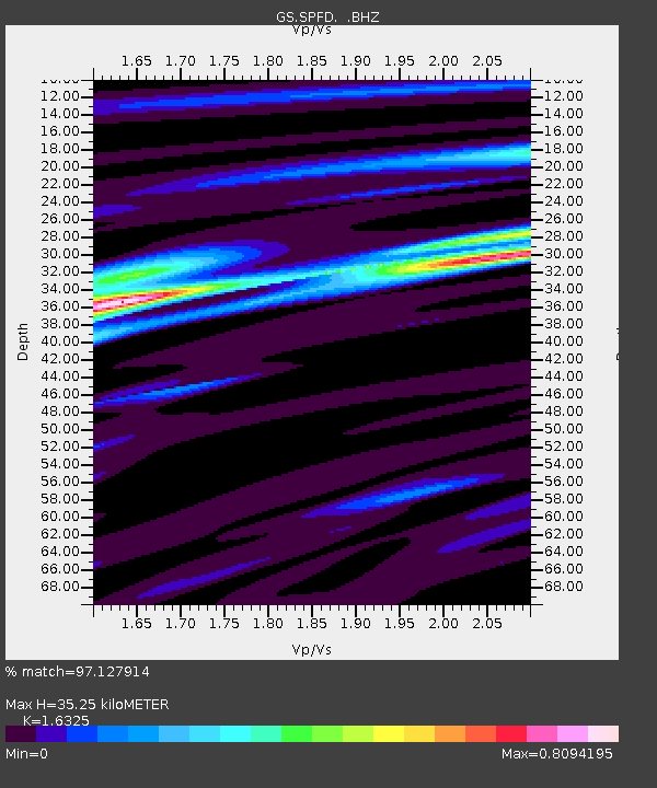
| Estimated Moho Depth: |
35.25 km |
| Estimated Crust Vp/Vs: |
1.63 |
| Assumed Crust Vp: |
6.419 km/s |
| Estimated Crust Vs: |
3.932 km/s |
| Estimated Crust Poisson's Ratio: |
0.20 |
|
| Radial Match: |
97.127914 % |
| Radial Bump: |
310 |
| Transverse Match: |
92.40399 % |
| Transverse Bump: |
400 |
| SOD ConfigId: |
424168 |
| Insert Time: |
2012-02-16 05:30:11.663 +0000 |
| GWidth: |
2.5 |
| Max Bumps: |
400 |
| Tol: |
0.001 |
|
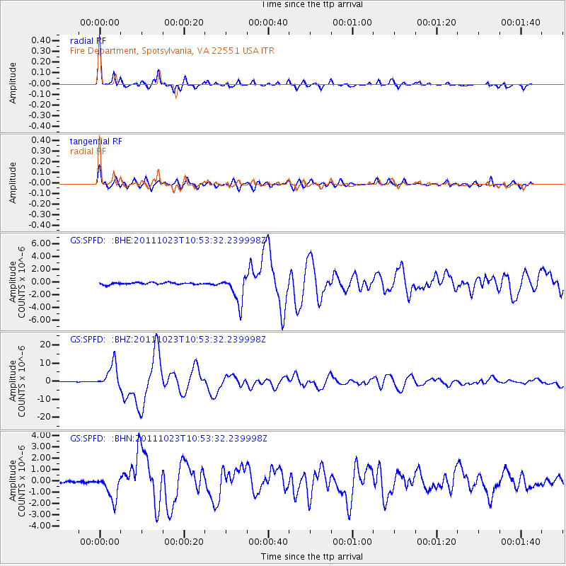
Signal To Noise
| Channel | StoN | STA | LTA |
| GS:SPFD: :BHZ:20111023T10:53:32.239998Z | 70.194466 | 6.793735E-6 | 9.678448E-8 |
| GS:SPFD: :BHN:20111023T10:53:32.239998Z | 4.268748 | 1.0110346E-6 | 2.3684572E-7 |
| GS:SPFD: :BHE:20111023T10:53:32.239998Z | 14.862863 | 2.1922237E-6 | 1.4749673E-7 |
| Arrivals |
| Ps | 3.6 SECOND |
| PpPs | 14 SECOND |
| PsPs/PpSs | 18 SECOND |


