
Station GS SPFD - Fire Department, Spotsylvania, VA 22551 USA
Network: GS - US Geological Survey Networks
Nearby stations (2 deg radius)
| Station | Name | (Lat, Lon) | Start / End | Elevation |
| SPFD | Fire Department, Spotsylvania, VA 22551 USA | (38.14, -77.52) | 2011-08-28 / 2999-12-31 | 79 m |
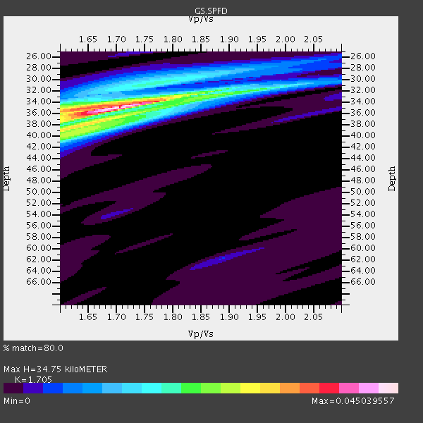
| Crust2 Type: | Q2,orogen/39km no ice, Appalachians, North Andes, 0.5 km seds. |
| Thickness Estimate: | 35 km |
| Thickness StdDev: | 1.2 km |
| Vp/Vs Estimate: | 1.71 |
| Vp/Vs StdDev: | 0.05 |
| Vs Estimate: | 3.765 km/s |
| Poisson's Ratio: | 0.24 |
| Peak Value: | 0.05 |
| Assumed Vp: | 6.419 km/s |
| Ps Weight: | 0.33333334 |
| PpPs Weight: | 0.33333334 |
| PsPs Weight: | 0.33333328 |
| Residual Complexity: | 0.518 |
| Nearby stations H: | +- |
| (2.0 deg) Vp/Vs: | +- |
3 with match > 90% ( 27.272728 %) and 4 with match > 80% ( 36.363636 %) out of 11.
Download stack as xyz text file.
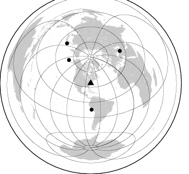
Azimuth Distribution of Events:
Prior Results for this Station
| Study | Thickness | Vp/Vs | Vp | Vs | Poissons Ratio | Extra |
| EARS | 35 km | 1.71 | 6.419 km/s | 3.765 km/s | 0.24 | |
| Crust2.0 | 39 km | 1.75 | 6.419 km/s | 3.659 km/s | 0.26 | Q2,orogen/39km no ice, Appalachians, North Andes, 0.5 km seds. |
| Global Maxima | 35 km | 1.71 | 6.419 km/s | 3.765 km/s | 0.24 | amp=0.045039557 |
| Local Maxima 1 | 39 km | 1.61 | 6.419 km/s | 3.993 km/s | 0.18 | amp=0.025159083 |
| Local Maxima 2 | 35 km | 1.60 | 6.419 km/s | 4.012 km/s | 0.18 | amp=0.020623762 |
| Local Maxima 3 | 35 km | 1.78 | 6.419 km/s | 3.606 km/s | 0.27 | amp=0.012372619 |
| Local Maxima 4 | 31 km | 1.71 | 6.419 km/s | 3.759 km/s | 0.24 | amp=0.011218962 |
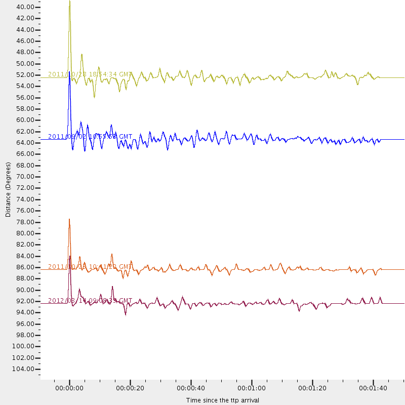
| Predicted Arrivals for vertical incidence (zero ray parameter) | |
| Ps | 3.82 SECOND |
| PpPs | 14.64 SECOND |
| PsPs/PpSs | 18.46 SECOND |
Events Processed for this Station
Download zip of receiver functions as SAC
Plot maxima for each earthquake.
Events Used in the Stack
(4 events)| Radial Match | Distance | Baz | FERegion | Time | Lat/Lon | Depth | Magnitude |
| 97.127914 | 86.3 deg | 42.198 deg | Turkey | 2011/10/23 10:41:22 GMT | (38.7, 43.5) | 16 km | 6.9 MB, 7.3 MS, 7.3 MW, 7.1 MW |
| 95.08775 | 52.3 deg | 178.096 deg | Near Coast Of Peru | 2011/10/28 18:54:34 GMT | (-14.4, -76.0) | 24 km | 6.5 MB, 6.9 MS, 6.9 MW, 6.9 MW |
| 93.87875 | 63.3 deg | 316.573 deg | Fox Islands, Aleutian Islands | 2011/09/02 10:55:53 GMT | (52.2, -171.7) | 32 km | 6.5 MB, 6.9 MS, 6.8 MW, 6.8 MW |
| 81.59273 | 92.3 deg | 329.184 deg | Off East Coast Of Honshu, Japan | 2012/03/14 09:08:35 GMT | (40.9, 144.9) | 12 km | 6.7 MB, 6.9 MS, 6.9 MW, 7.0 MW |
Losers
(7 events)| Radial Match | Distance | Baz | FERegion | Time | Lat/Lon | Depth | Magnitude | Reason |
| 77.2685 | 90.4 deg | 4.032 deg | Southwestern Siberia, Russia | 2012/02/26 06:17:19 GMT | (51.7, 96.0) | 12 km | 6.4 MB, 6.6 MS, 6.7 MW, 6.5 MW | |
| 76.41348 | 36.8 deg | 304.305 deg | Vancouver Island, Canada Region | 2011/09/09 19:41:34 GMT | (49.5, -126.9) | 22 km | 6.3 MB, 6.4 MS, 6.4 MW, 6.5 MW | |
| 55.63592 | 63.4 deg | 316.6 deg | Fox Islands, Aleutian Islands | 2011/10/25 03:24:49 GMT | (52.2, -171.8) | 38 km | 5.9 MB, 5.3 MS, 5.7 MW, 5.7 MW | |
| 54.27354 | 93.7 deg | 330.348 deg | Near East Coast Of Honshu, Japan | 2011/09/17 07:34:27 GMT | (40.3, 142.7) | 30 km | 5.5 MB, 5.2 MS, 5.7 MW, 5.9 ME | |
| 40.810616 | 70.6 deg | 322.951 deg | Near Islands, Aleutian Islands | 2011/09/14 18:10:09 GMT | (53.1, 173.0) | 15 km | 6.1 MB, 5.7 MS, 6.0 MW, 6.0 MW | |
| 37.811546 | 97.7 deg | 329.22 deg | Near East Coast Of Honshu, Japan | 2011/09/15 08:00:09 GMT | (36.3, 141.3) | 28 km | 5.8 MB, 6.0 MS, 6.2 MW, 6.1 MW | |
| 34.171032 | 75.3 deg | 177.008 deg | Near Coast Of Central Chile | 2012/02/11 02:58:17 GMT | (-37.5, -73.9) | 20 km | 5.6 MB, 5.3 MS, 5.6 MW, 5.7 MW |
