You are here: Home > Network List > XJ13 - CRAFTI Stations List
> Station PR52 Alailelai Boma > Earthquake Result Viewer
PR52 Alailelai Boma - Earthquake Result Viewer
| Earthquake location: |
Bouvet Island Region |
| Earthquake latitude/longitude: |
-53.5/8.7 |
| Earthquake time(UTC): |
2014/04/15 (105) 03:57:02 GMT |
| Earthquake Depth: |
12 km |
| Earthquake Magnitude: |
6.9 MWP, 6.8 MI, 6.9 MI |
| Earthquake Catalog/Contributor: |
NEIC PDE/NEIC COMCAT |
|
| Network: |
XJ CRAFTI |
| Station: |
PR52 Alailelai Boma |
| Lat/Lon: |
2.96 S/35.70 E |
| Elevation: |
2420 m |
|
| Distance: |
55.1 deg |
| Az: |
33.566 deg |
| Baz: |
199.301 deg |
| Ray Param: |
0.0650249 |
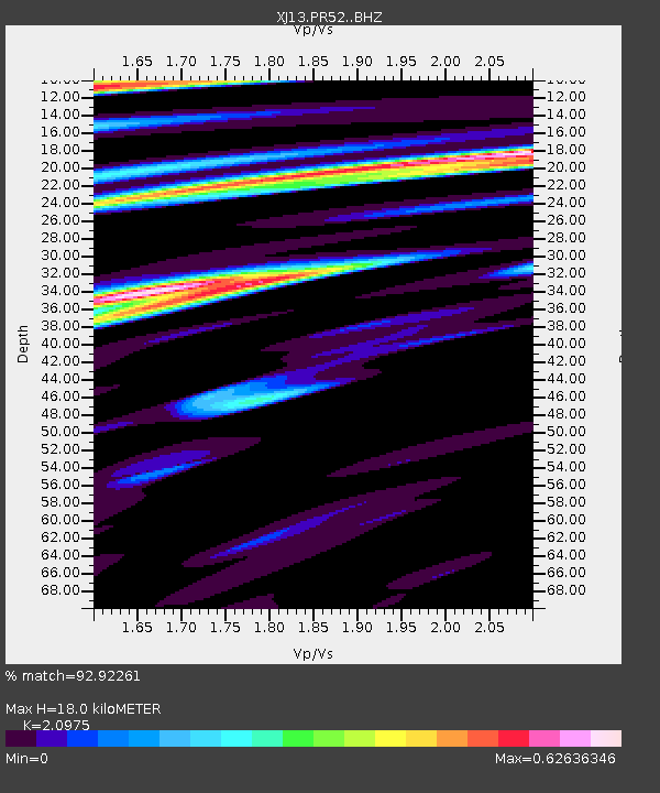
| Estimated Moho Depth: |
18.0 km |
| Estimated Crust Vp/Vs: |
2.10 |
| Assumed Crust Vp: |
6.576 km/s |
| Estimated Crust Vs: |
3.135 km/s |
| Estimated Crust Poisson's Ratio: |
0.35 |
|
| Radial Match: |
92.92261 % |
| Radial Bump: |
400 |
| Transverse Match: |
74.749504 % |
| Transverse Bump: |
400 |
| SOD ConfigId: |
3390531 |
| Insert Time: |
2019-04-11 10:04:19.267 +0000 |
| GWidth: |
2.5 |
| Max Bumps: |
400 |
| Tol: |
0.001 |
|

Signal To Noise
| Channel | StoN | STA | LTA |
| XJ:PR52: :BHZ:20140415T04:06:03.300024Z | 4.402666 | 8.3633915E-7 | 1.8996198E-7 |
| XJ:PR52: :BHN:20140415T04:06:03.300024Z | 1.9604498 | 6.68882E-7 | 3.4118804E-7 |
| XJ:PR52: :BHE:20140415T04:06:03.300024Z | 1.4701836 | 6.298494E-7 | 4.284155E-7 |
| Arrivals |
| Ps | 3.1 SECOND |
| PpPs | 8.1 SECOND |
| PsPs/PpSs | 11 SECOND |


