
Station XJ PR52 - Alailelai Boma
Network: XJ13 - CRAFTI
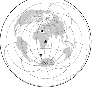
Nearby stations (2 deg radius)
| Station | Name | (Lat, Lon) | Start / End | Elevation |
| PR52 | Alailelai Boma | (-2.96, 35.70) | 2013-01-21 / 2014-12-05 | 2420 m |
| Crust2 Type: | I2,late Proter., 1 km seds. |
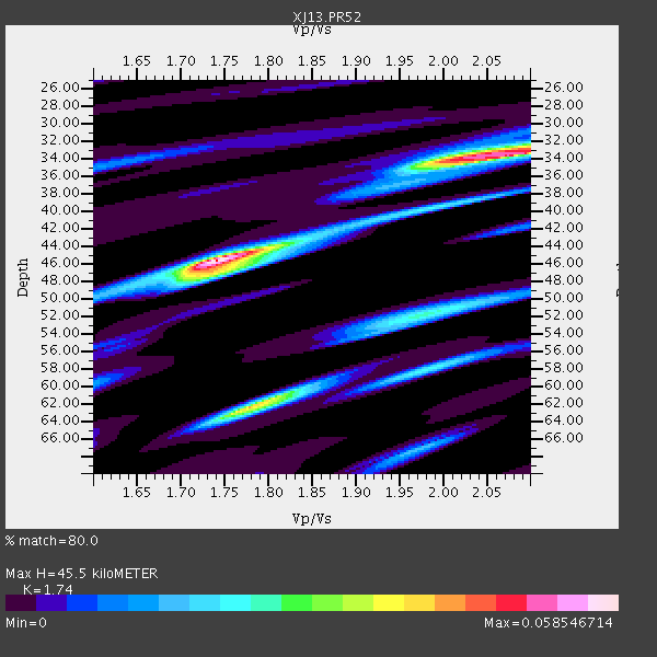
| Thickness Estimate: | 46 km |
| Thickness StdDev: | 5.8 km |
| Vp/Vs Estimate: | 1.74 |
| Vp/Vs StdDev: | 0.13 |
| Vs Estimate: | 3.779 km/s |
| Poisson's Ratio: | 0.25 |
| Peak Value: | 0.06 |
| Assumed Vp: | 6.576 km/s |
| Ps Weight: | 0.33333334 |
| PpPs Weight: | 0.33333334 |
| PsPs Weight: | 0.33333328 |
| Residual Complexity: | 0.744 |
| Nearby stations H: | +- |
| (2.0 deg) Vp/Vs: | +- |
1 with match > 90% ( 10.0 %) and 2 with match > 80% ( 20.0 %) out of 10.
Download stack as xyz text file.
Azimuth Distribution of Events:
Prior Results for this Station
| Study | Thickness | Vp/Vs | Vp | Vs | Poissons Ratio | Extra |
| EARS | 46 km | 1.74 | 6.576 km/s | 3.779 km/s | 0.25 | |
| Crust2.0 | 38 km | 1.78 | 6.576 km/s | 3.695 km/s | 0.27 | I2,late Proter., 1 km seds. |
| Global Maxima | 46 km | 1.74 | 6.576 km/s | 3.779 km/s | 0.25 | amp=0.058546714 |
| Local Maxima 1 | 34 km | 2.05 | 6.576 km/s | 3.208 km/s | 0.34 | amp=0.050650217 |
| Local Maxima 2 | 62 km | 1.78 | 6.576 km/s | 3.7 km/s | 0.27 | amp=0.04112992 |
| Local Maxima 3 | 52 km | 1.99 | 6.576 km/s | 3.313 km/s | 0.33 | amp=0.02292306 |
| Local Maxima 4 | 47 km | 1.73 | 6.576 km/s | 3.796 km/s | 0.25 | amp=0.020929644 |
| Predicted Arrivals for vertical incidence (zero ray parameter) | |
| Ps | 5.12 SECOND |
| PpPs | 18.96 SECOND |
| PsPs/PpSs | 24.08 SECOND |
Events Processed for this Station
Download zip of receiver functions as SAC
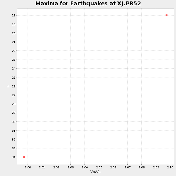
Plot maxima for each earthquake.
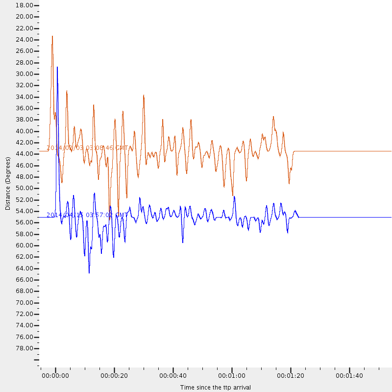
Events Used in the Stack
(2 events)| Radial Match | Distance | Baz | FERegion | Time | Lat/Lon | Depth | Magnitude |
| 92.92261 | 55.1 deg | 199.301 deg | Bouvet Island Region | 2014/04/15 03:57:02 GMT | (-53.5, 8.7) | 12 km | 6.9 MWP, 6.8 MI, 6.9 MI |
| 81.75952 | 43.4 deg | 342.387 deg | Greece | 2014/02/03 03:08:46 GMT | (38.3, 20.4) | 5.0 km | 6.0 MWW, 6.0 MWB, 6.1 MWC |
Losers
(8 events)| Radial Match | Distance | Baz | FERegion | Time | Lat/Lon | Depth | Magnitude | Reason |
| 81.65642 | 59.4 deg | 79.258 deg | Nicobar Islands, India Region | 2014/03/14 13:38:06 GMT | (7.8, 94.3) | 10 km | 5.5 MWW, 5.4 MWB, 5.6 MWC | |
| 76.50884 | 92.8 deg | 62.814 deg | Ryukyu Islands, Japan | 2014/03/02 20:11:23 GMT | (27.4, 127.4) | 119 km | 6.5 MWW, 6.4 MWB, 6.5 MWC, 6.6 MI, 6.7 MI | |
| 58.87964 | 84.3 deg | 96.806 deg | Flores Sea | 2014/01/23 00:52:15 GMT | (-7.1, 120.3) | 579 km | 5.5 MWB, 5.5 MWC | |
| 54.66464 | 58.4 deg | 44.1 deg | Xizang | 2014/02/12 09:19:49 GMT | (35.9, 82.6) | 10 km | 6.9 MWW, 6.9 MWB, 6.9 MWC | |
| 52.53426 | 36.3 deg | 34.602 deg | Southern Iran | 2014/02/02 14:26:47 GMT | (26.6, 57.8) | 19 km | 5.3 MW | |
| 48.288727 | 91.6 deg | 81.791 deg | Mindanao, Philippines | 2014/01/26 19:12:19 GMT | (8.3, 126.9) | 47 km | 4.7 mb | |
| 48.27247 | 94.3 deg | 97.129 deg | Banda Sea | 2014/01/18 09:34:21 GMT | (-6.9, 130.4) | 150 km | 4.7 mb | |
| 46.7693 | 84.5 deg | 90.797 deg | Sulawesi, Indonesia | 2014/02/23 15:06:52 GMT | (-1.1, 120.2) | 24 km | 5.4 MW |

