You are here: Home > Network List > GS - US Geological Survey Networks Stations List
> Station SPFD Fire Department, Spotsylvania, VA 22551 USA > Earthquake Result Viewer
SPFD Fire Department, Spotsylvania, VA 22551 USA - Earthquake Result Viewer
| Earthquake location: |
Near Coast Of Peru |
| Earthquake latitude/longitude: |
-14.4/-76.0 |
| Earthquake time(UTC): |
2011/10/28 (301) 18:54:34 GMT |
| Earthquake Depth: |
24 km |
| Earthquake Magnitude: |
6.5 MB, 6.9 MS, 6.9 MW, 6.9 MW |
| Earthquake Catalog/Contributor: |
WHDF/NEIC |
|
| Network: |
GS US Geological Survey Networks |
| Station: |
SPFD Fire Department, Spotsylvania, VA 22551 USA |
| Lat/Lon: |
38.14 N/77.52 W |
| Elevation: |
79 m |
|
| Distance: |
52.3 deg |
| Az: |
358.45 deg |
| Baz: |
178.096 deg |
| Ray Param: |
0.06680313 |
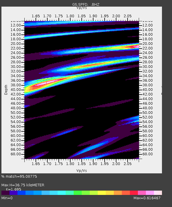
| Estimated Moho Depth: |
36.75 km |
| Estimated Crust Vp/Vs: |
1.70 |
| Assumed Crust Vp: |
6.419 km/s |
| Estimated Crust Vs: |
3.787 km/s |
| Estimated Crust Poisson's Ratio: |
0.23 |
|
| Radial Match: |
95.08775 % |
| Radial Bump: |
370 |
| Transverse Match: |
84.79828 % |
| Transverse Bump: |
400 |
| SOD ConfigId: |
424168 |
| Insert Time: |
2012-02-16 10:35:58.767 +0000 |
| GWidth: |
2.5 |
| Max Bumps: |
400 |
| Tol: |
0.001 |
|

Signal To Noise
| Channel | StoN | STA | LTA |
| GS:SPFD: :BHZ:20111028T19:03:12.815024Z | 12.904342 | 3.7575062E-6 | 2.9118152E-7 |
| GS:SPFD: :BHN:20111028T19:03:12.815024Z | 3.0824044 | 2.0494804E-6 | 6.648967E-7 |
| GS:SPFD: :BHE:20111028T19:03:12.815024Z | 1.4404212 | 5.856006E-7 | 4.0654817E-7 |
| Arrivals |
| Ps | 4.2 SECOND |
| PpPs | 15 SECOND |
| PsPs/PpSs | 19 SECOND |


