You are here: Home > Network List > IC - New China Digital Seismograph Network Stations List
> Station HIA Hailar, Neimenggu Province, China > Earthquake Result Viewer
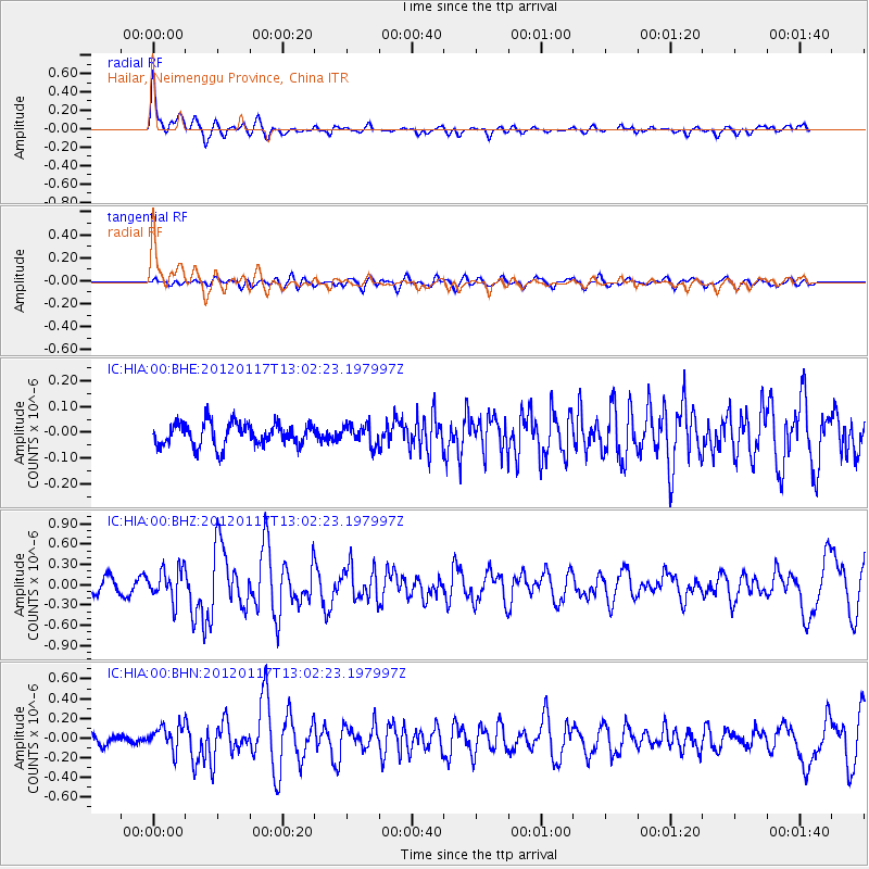
HIA Hailar, Neimenggu Province, China - Earthquake Result Viewer
*The percent match for this event was below the threshold and hence no stack was calculated.
| Earthquake location: |
Samar, Philippines |
| Earthquake latitude/longitude: |
11.2/125.8 |
| Earthquake time(UTC): |
2012/01/17 (017) 12:55:34 GMT |
| Earthquake Depth: |
20 km |
| Earthquake Magnitude: |
5.7 MB, 5.4 MS, 5.7 MW, 5.7 MW |
| Earthquake Catalog/Contributor: |
WHDF/NEIC |
|
| Network: |
IC New China Digital Seismograph Network |
| Station: |
HIA Hailar, Neimenggu Province, China |
| Lat/Lon: |
49.27 N/119.74 E |
| Elevation: |
620 m |
|
| Distance: |
38.3 deg |
| Az: |
353.558 deg |
| Baz: |
170.324 deg |
| Ray Param: |
$rayparam |
*The percent match for this event was below the threshold and hence was not used in the summary stack. |
|
| Radial Match: |
79.63732 % |
| Radial Bump: |
400 |
| Transverse Match: |
57.268234 % |
| Transverse Bump: |
400 |
| SOD ConfigId: |
436445 |
| Insert Time: |
2012-04-05 14:52:35.945 +0000 |
| GWidth: |
2.5 |
| Max Bumps: |
400 |
| Tol: |
0.001 |
|
Signal To Noise
| Channel | StoN | STA | LTA |
| IC:HIA:00:BHZ:20120117T13:02:23.197997Z | 3.0923347 | 2.3502068E-7 | 7.6001044E-8 |
| IC:HIA:00:BHN:20120117T13:02:23.197997Z | 2.434816 | 1.2195635E-7 | 5.008853E-8 |
| IC:HIA:00:BHE:20120117T13:02:23.197997Z | 0.84592193 | 3.803882E-8 | 4.4967294E-8 |
| Arrivals |
| Ps | |
| PpPs | |
| PsPs/PpSs | |


