You are here: Home > Network List > IC - New China Digital Seismograph Network Stations List
> Station HIA Hailar, Neimenggu Province, China > Earthquake Result Viewer
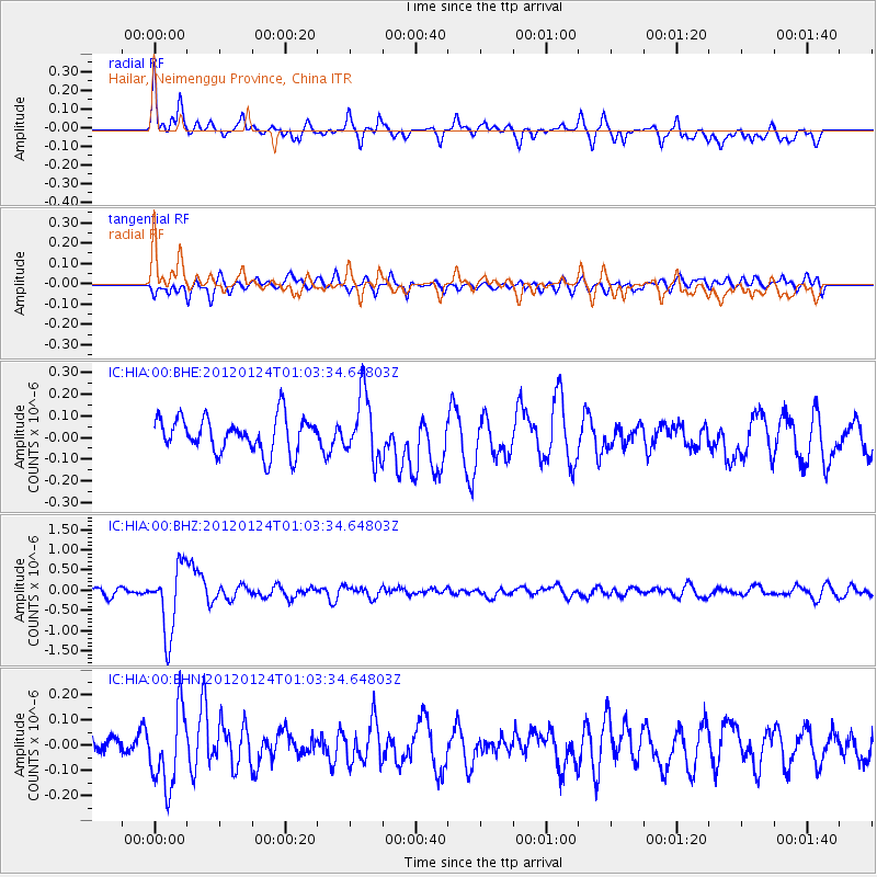
HIA Hailar, Neimenggu Province, China - Earthquake Result Viewer
*The percent match for this event was below the threshold and hence no stack was calculated.
| Earthquake location: |
South Of Fiji Islands |
| Earthquake latitude/longitude: |
-25.0/178.5 |
| Earthquake time(UTC): |
2012/01/24 (024) 00:52:05 GMT |
| Earthquake Depth: |
580 km |
| Earthquake Magnitude: |
5.8 MB, 6.3 MW, 6.4 MW |
| Earthquake Catalog/Contributor: |
WHDF/NEIC |
|
| Network: |
IC New China Digital Seismograph Network |
| Station: |
HIA Hailar, Neimenggu Province, China |
| Lat/Lon: |
49.27 N/119.74 E |
| Elevation: |
620 m |
|
| Distance: |
90.5 deg |
| Az: |
325.933 deg |
| Baz: |
129.091 deg |
| Ray Param: |
$rayparam |
*The percent match for this event was below the threshold and hence was not used in the summary stack. |
|
| Radial Match: |
75.25257 % |
| Radial Bump: |
400 |
| Transverse Match: |
54.253902 % |
| Transverse Bump: |
400 |
| SOD ConfigId: |
436445 |
| Insert Time: |
2012-04-05 16:43:42.223 +0000 |
| GWidth: |
2.5 |
| Max Bumps: |
400 |
| Tol: |
0.001 |
|
Signal To Noise
| Channel | StoN | STA | LTA |
| IC:HIA:00:BHZ:20120124T01:03:34.64803Z | 10.516456 | 8.417245E-7 | 8.00388E-8 |
| IC:HIA:00:BHN:20120124T01:03:34.64803Z | 3.7991765 | 1.5167261E-7 | 3.9922494E-8 |
| IC:HIA:00:BHE:20120124T01:03:34.64803Z | 1.8559784 | 1.4924801E-7 | 8.0414736E-8 |
| Arrivals |
| Ps | |
| PpPs | |
| PsPs/PpSs | |


