You are here: Home > Network List > Z910 - Southeastern Suture of the Appalachian Margin Experiment Stations List
> Station E30 Clark Farm, Garfield, GA > Earthquake Result Viewer
E30 Clark Farm, Garfield, GA - Earthquake Result Viewer
| Earthquake location: |
Vancouver Island, Canada Region |
| Earthquake latitude/longitude: |
49.8/-127.4 |
| Earthquake time(UTC): |
2014/04/24 (114) 03:10:13 GMT |
| Earthquake Depth: |
11 km |
| Earthquake Magnitude: |
6.7 MWP, 6.7 MI |
| Earthquake Catalog/Contributor: |
NEIC PDE/NEIC COMCAT |
|
| Network: |
Z9 Southeastern Suture of the Appalachian Margin Experiment |
| Station: |
E30 Clark Farm, Garfield, GA |
| Lat/Lon: |
32.70 N/82.11 W |
| Elevation: |
98 m |
|
| Distance: |
37.5 deg |
| Az: |
99.833 deg |
| Baz: |
310.847 deg |
| Ray Param: |
0.07611134 |
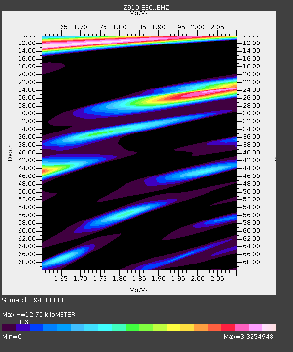
| Estimated Moho Depth: |
12.75 km |
| Estimated Crust Vp/Vs: |
1.60 |
| Assumed Crust Vp: |
6.565 km/s |
| Estimated Crust Vs: |
4.103 km/s |
| Estimated Crust Poisson's Ratio: |
0.18 |
|
| Radial Match: |
94.38838 % |
| Radial Bump: |
399 |
| Transverse Match: |
63.44833 % |
| Transverse Bump: |
400 |
| SOD ConfigId: |
3390531 |
| Insert Time: |
2019-04-11 14:35:10.855 +0000 |
| GWidth: |
2.5 |
| Max Bumps: |
400 |
| Tol: |
0.001 |
|

Signal To Noise
| Channel | StoN | STA | LTA |
| Z9:E30: :BHZ:20140424T03:16:55.539999Z | 30.892199 | 4.426255E-6 | 1.4328067E-7 |
| Z9:E30: :BHN:20140424T03:16:55.539999Z | 7.2825546 | 2.9192634E-6 | 4.0085703E-7 |
| Z9:E30: :BHE:20140424T03:16:55.539999Z | 9.0851145 | 4.360374E-6 | 4.7994706E-7 |
| Arrivals |
| Ps | 1.3 SECOND |
| PpPs | 4.6 SECOND |
| PsPs/PpSs | 5.9 SECOND |


