
Station Z9 E30 - Clark Farm, Garfield, GA
Network: Z910 - Southeastern Suture of the Appalachian Margin Experiment
Nearby stations (2 deg radius)
| Station | Name | (Lat, Lon) | Start / End | Elevation |
| E30 | Clark Farm, Garfield, GA | (32.70, -82.11) | 2012-05-05 / 2014-05-17 | 98 m |
| Crust2 Type: | DG,thin Platform 1 km seds. |
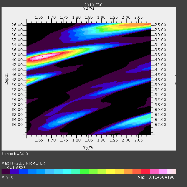
| Thickness Estimate: | 38 km |
| Thickness StdDev: | 5.7 km |
| Vp/Vs Estimate: | 1.66 |
| Vp/Vs StdDev: | 0.14 |
| Vs Estimate: | 3.949 km/s |
| Poisson's Ratio: | 0.22 |
| Peak Value: | 0.11 |
| Assumed Vp: | 6.565 km/s |
| Ps Weight: | 0.33333334 |
| PpPs Weight: | 0.33333334 |
| PsPs Weight: | 0.33333328 |
| Residual Complexity: | 0.740 |
| Nearby stations H: | +- |
| (2.0 deg) Vp/Vs: | +- |
2 with match > 90% ( 5.882353 %) and 7 with match > 80% ( 20.588236 %) out of 34.
Download stack as xyz text file.
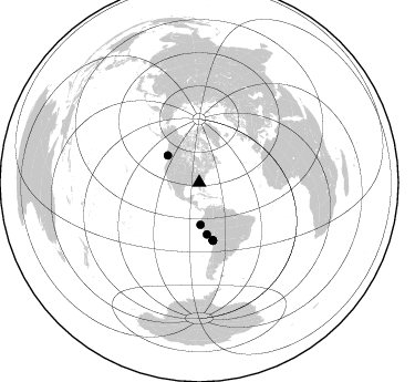
Azimuth Distribution of Events:
Prior Results for this Station
| Study | Thickness | Vp/Vs | Vp | Vs | Poissons Ratio | Extra |
| EARS | 38 km | 1.66 | 6.565 km/s | 3.949 km/s | 0.22 | |
| Crust2.0 | 31 km | 1.78 | 6.565 km/s | 3.684 km/s | 0.27 | DG,thin Platform 1 km seds. |
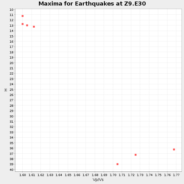
| Global Maxima | 38 km | 1.66 | 6.565 km/s | 3.949 km/s | 0.22 | amp=0.114504196 |
| Local Maxima 1 | 48 km | 1.60 | 6.565 km/s | 4.103 km/s | 0.18 | amp=0.08585382 |
| Local Maxima 2 | 25 km | 2.10 | 6.565 km/s | 3.13 km/s | 0.35 | amp=0.08361096 |
| Local Maxima 3 | 39 km | 1.72 | 6.565 km/s | 3.811 km/s | 0.25 | amp=0.06177358 |
| Local Maxima 4 | 26 km | 1.98 | 6.565 km/s | 3.32 km/s | 0.33 | amp=0.054323725 |
| Predicted Arrivals for vertical incidence (zero ray parameter) | |
| Ps | 3.89 SECOND |
| PpPs | 15.62 SECOND |
| PsPs/PpSs | 19.50 SECOND |
Events Processed for this Station
Download zip of receiver functions as SAC
Plot maxima for each earthquake.
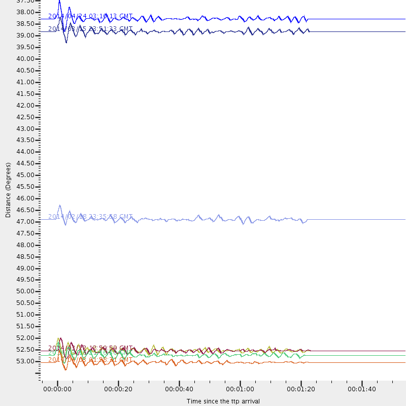
Events Used in the Stack
(7 events)| Radial Match | Distance | Baz | FERegion | Time | Lat/Lon | Depth | Magnitude |
| 94.38838 | 37.5 deg | 310.847 deg | Vancouver Island, Canada Region | 2014/04/24 03:10:13 GMT | (49.8, -127.4) | 11 km | 6.7 MWP, 6.7 MI |
| 90.97127 | 38.1 deg | 178.14 deg | Near Coast Of Northern Peru | 2014/03/15 23:51:33 GMT | (-5.6, -81.0) | 29 km | 6.3 MWW, 6.2 MWB, 6.3 MWC |
| 88.91598 | 53.8 deg | 166.528 deg | Near Coast Of Northern Chile | 2014/04/03 01:58:31 GMT | (-20.3, -70.6) | 23 km | 6.5 MWW, 6.5 MWB, 6.6 MWC |
| 88.47306 | 53.3 deg | 166.762 deg | Near Coast Of Northern Chile | 2014/03/22 12:59:59 GMT | (-19.8, -70.9) | 20 km | 6.2 MWW, 6.2 MWB, 6.3 MWC, 6.4 MWC |
| 87.405785 | 53.5 deg | 166.521 deg | Near Coast Of Northern Chile | 2014/03/16 21:16:30 GMT | (-19.9, -70.6) | 20 km | 6.7 MWW, 6.7 MWC, 7.0 MI |
| 83.16673 | 53.3 deg | 166.685 deg | Near Coast Of Northern Chile | 2014/03/23 18:20:03 GMT | (-19.7, -70.8) | 35 km | 6.0 MB, 6.2 MWB, 6.2 MWW, 6.3 MWC |
| 82.060455 | 47.0 deg | 171.356 deg | Near Coast Of Peru | 2014/02/18 23:35:58 GMT | (-14.2, -75.6) | 57 km | 6.0 MWB, 5.9 MWW, 5.9 MWC, 6.0 MWC |
Losers
(27 events)| Radial Match | Distance | Baz | FERegion | Time | Lat/Lon | Depth | Magnitude | Reason |
| 97.58795 | 53.2 deg | 166.666 deg | Near Coast Of Northern Chile | 2014/04/01 23:46:46 GMT | (-19.6, -70.8) | 20 km | 8.2 MWW, 8.0 MI, 8.1 MWC | |
| 94.81452 | 54.1 deg | 166.526 deg | Near Coast Of Northern Chile | 2014/04/03 02:43:14 GMT | (-20.5, -70.5) | 31 km | 7.7 MWW, 7.4 MI, 7.7 MWC | |
| 91.21106 | 53.2 deg | 166.878 deg | Near Coast Of Northern Chile | 2014/03/22 13:29:57 GMT | (-19.8, -71.0) | 10 km | 5.5 MB, 5.4 MWR, 5.6 MWW, 5.6 MWC | |
| 90.66523 | 35.1 deg | 295.856 deg | Off Coast Of Northern California | 2014/03/10 05:18:13 GMT | (40.8, -125.1) | 17 km | 6.8 MW, 6.8 MWR, 6.9 MWW, 6.9 MWB, 7.0 MI, 7.0 MWC | |
| 85.656006 | 54.1 deg | 166.826 deg | Near Coast Of Northern Chile | 2014/04/04 01:37:51 GMT | (-20.6, -70.7) | 20 km | 6.1 MWP, 6.1 MWB, 6.1 MWW, 6.3 MWC | |
| 81.89373 | 53.2 deg | 166.287 deg | Near Coast Of Northern Chile | 2014/04/02 00:04:54 GMT | (-19.6, -70.5) | 34 km | 5.5 MB | |
| 79.86406 | 53.1 deg | 165.877 deg | Near Coast Of Northern Chile | 2014/04/01 23:59:57 GMT | (-19.5, -70.2) | 22 km | 5.8 MB | |
| 77.32014 | 54.3 deg | 166.658 deg | Near Coast Of Northern Chile | 2014/04/03 05:26:16 GMT | (-20.8, -70.5) | 24 km | 6.2 MWP, 6.2 MWR, 6.3 MWW, 6.5 MWC | |
| 70.373924 | 54.1 deg | 166.774 deg | Near Coast Of Northern Chile | 2014/04/03 09:23:21 GMT | (-20.6, -70.7) | 15 km | 5.6 MB, 5.3 MWR | |
| 66.66153 | 87.2 deg | 200.362 deg | Southern East Pacific Rise | 2014/05/12 18:38:37 GMT | (-50.0, -114.7) | 8.2 km | 5.8 MB | |
| 66.46527 | 46.9 deg | 172.277 deg | Near Coast Of Peru | 2014/03/15 08:59:21 GMT | (-14.1, -76.3) | 20 km | 6.1 MWW, 6.0 MWB, 6.2 MWC | |
| 63.97303 | 53.6 deg | 166.835 deg | Near Coast Of Northern Chile | 2014/04/02 04:46:18 GMT | (-20.2, -70.9) | 10 km | 5.8 MB | |
| 63.884254 | 86.7 deg | 325.339 deg | Kuril Islands | 2014/01/08 16:50:28 GMT | (46.5, 153.2) | 40 km | 5.0 mb | |
| 63.459103 | 56.5 deg | 333.111 deg | Northern Alaska | 2014/05/03 08:57:12 GMT | (67.6, -162.2) | 0.9 km | 5.5 MB | |
| 62.752323 | 53.7 deg | 166.708 deg | Near Coast Of Northern Chile | 2014/05/05 11:21:19 GMT | (-20.2, -70.7) | 24 km | 5.4 MW | |
| 62.25756 | 65.9 deg | 170.294 deg | Near Coast Of Central Chile | 2014/04/05 02:22:38 GMT | (-32.8, -71.6) | 40 km | 5.6 MWC, 5.6 MWC | |
| 62.012463 | 56.6 deg | 333.213 deg | Northern Alaska | 2014/04/18 18:56:47 GMT | (67.7, -162.5) | 17 km | 5.7 MW | |
| 61.673817 | 53.4 deg | 166.922 deg | Near Coast Of Northern Chile | 2014/04/02 11:07:33 GMT | (-20.0, -71.0) | 27 km | 5.4 Mww | |
| 61.49481 | 54.5 deg | 158.765 deg | Southern Bolivia | 2014/01/27 16:42:37 GMT | (-19.3, -63.9) | 600 km | 5.6 MWB | |
| 60.44242 | 76.9 deg | 177.912 deg | Off Coast Of Southern Chile | 2014/01/07 12:06:13 GMT | (-44.5, -79.3) | 35 km | 5.2 MW | |
| 58.14688 | 52.5 deg | 323.443 deg | Southern Alaska | 2014/05/10 14:16:08 GMT | (60.0, -152.2) | 96 km | 5.8 ML, 5.5 MI, 5.7 MWP | |
| 57.09518 | 64.3 deg | 318.581 deg | Fox Islands, Aleutian Islands | 2014/02/26 21:13:40 GMT | (53.6, -171.8) | 265 km | 6.1 MWW, 5.9 MI, 5.9 ML, 6.1 MWC, 6.1 MWB, 6.2 MWC | |
| 56.340824 | 69.4 deg | 318.132 deg | Andreanof Islands, Aleutian Is. | 2014/01/16 07:33:09 GMT | (51.2, -179.2) | 27 km | 5.5 MWB, 5.2 ML, 5.5 ML, 5.6 MWC | |
| 55.101223 | 54.0 deg | 166.584 deg | Near Coast Of Northern Chile | 2014/04/02 19:45:49 GMT | (-20.4, -70.6) | 17 km | 5.3 MW | |
| 50.807095 | 53.4 deg | 166.854 deg | Near Coast Of Northern Chile | 2014/04/01 23:57:57 GMT | (-19.9, -70.9) | 20 km | 6.9 MWW, 6.9 MWC | |
| 50.55098 | 31.0 deg | 174.637 deg | Near Coast Of Ecuador | 2014/03/09 20:29:52 GMT | (1.7, -79.4) | 6.0 km | 5.6 MWW, 5.6 MWC, 5.6 MWB | |
| 46.382797 | 82.0 deg | 50.83 deg | Southern Greece | 2014/04/04 20:08:07 GMT | (37.2, 23.8) | 107 km | 5.5 MWB, 5.5 MWR, 5.6 MWC, 5.6 MWW |

