You are here: Home > Network List > Z910 - Southeastern Suture of the Appalachian Margin Experiment Stations List
> Station W01 Suwannee River Water District, Perry, FL > Earthquake Result Viewer
W01 Suwannee River Water District, Perry, FL - Earthquake Result Viewer
| Earthquake location: |
Vancouver Island, Canada Region |
| Earthquake latitude/longitude: |
49.8/-127.4 |
| Earthquake time(UTC): |
2014/04/24 (114) 03:10:13 GMT |
| Earthquake Depth: |
11 km |
| Earthquake Magnitude: |
6.7 MWP, 6.7 MI |
| Earthquake Catalog/Contributor: |
NEIC PDE/NEIC COMCAT |
|
| Network: |
Z9 Southeastern Suture of the Appalachian Margin Experiment |
| Station: |
W01 Suwannee River Water District, Perry, FL |
| Lat/Lon: |
30.20 N/83.91 W |
| Elevation: |
12 m |
|
| Distance: |
38.0 deg |
| Az: |
104.532 deg |
| Baz: |
313.628 deg |
| Ray Param: |
0.07580666 |
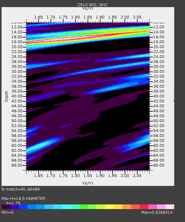
| Estimated Moho Depth: |
16.5 km |
| Estimated Crust Vp/Vs: |
1.75 |
| Assumed Crust Vp: |
6.565 km/s |
| Estimated Crust Vs: |
3.751 km/s |
| Estimated Crust Poisson's Ratio: |
0.26 |
|
| Radial Match: |
91.68499 % |
| Radial Bump: |
248 |
| Transverse Match: |
91.68499 % |
| Transverse Bump: |
248 |
| SOD ConfigId: |
3390531 |
| Insert Time: |
2019-04-11 14:35:11.255 +0000 |
| GWidth: |
2.5 |
| Max Bumps: |
400 |
| Tol: |
0.001 |
|

Signal To Noise
| Channel | StoN | STA | LTA |
| Z9:W01: :BHZ:20140424T03:16:59.860006Z | 41.58378 | 8.899589E-6 | 2.140159E-7 |
| $trig.getChannelId() | $trig.getValue() | $trig.getSTA() | $trig.getLTA() |
| Z9:W01: :BHE:20140424T03:16:59.860006Z | 12.85362 | 2.1608291E-6 | 1.6811055E-7 |
| Arrivals |
| Ps | 2.0 SECOND |
| PpPs | 6.4 SECOND |
| PsPs/PpSs | 8.4 SECOND |


