You are here: Home > Network List > Z910 - Southeastern Suture of the Appalachian Margin Experiment Stations List
> Station W21 Melatchee Woodlands, Marshallville, GA > Earthquake Result Viewer
W21 Melatchee Woodlands, Marshallville, GA - Earthquake Result Viewer
| Earthquake location: |
Vancouver Island, Canada Region |
| Earthquake latitude/longitude: |
49.8/-127.4 |
| Earthquake time(UTC): |
2014/04/24 (114) 03:10:13 GMT |
| Earthquake Depth: |
11 km |
| Earthquake Magnitude: |
6.7 MWP, 6.7 MI |
| Earthquake Catalog/Contributor: |
NEIC PDE/NEIC COMCAT |
|
| Network: |
Z9 Southeastern Suture of the Appalachian Margin Experiment |
| Station: |
W21 Melatchee Woodlands, Marshallville, GA |
| Lat/Lon: |
32.40 N/83.86 W |
| Elevation: |
131 m |
|
| Distance: |
36.6 deg |
| Az: |
101.812 deg |
| Baz: |
311.49 deg |
| Ray Param: |
0.07661298 |
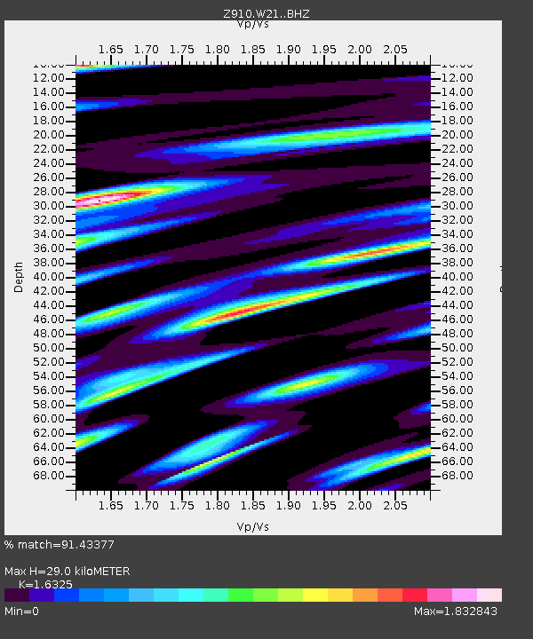
| Estimated Moho Depth: |
29.0 km |
| Estimated Crust Vp/Vs: |
1.63 |
| Assumed Crust Vp: |
6.565 km/s |
| Estimated Crust Vs: |
4.021 km/s |
| Estimated Crust Poisson's Ratio: |
0.20 |
|
| Radial Match: |
91.43377 % |
| Radial Bump: |
400 |
| Transverse Match: |
73.2738 % |
| Transverse Bump: |
400 |
| SOD ConfigId: |
3390531 |
| Insert Time: |
2019-04-11 14:35:22.460 +0000 |
| GWidth: |
2.5 |
| Max Bumps: |
400 |
| Tol: |
0.001 |
|

Signal To Noise
| Channel | StoN | STA | LTA |
| Z9:W21: :BHZ:20140424T03:16:47.659994Z | 45.09832 | 5.475434E-6 | 1.2141105E-7 |
| Z9:W21: :BHN:20140424T03:16:47.659994Z | 13.626293 | 3.509239E-6 | 2.5753437E-7 |
| Z9:W21: :BHE:20140424T03:16:47.659994Z | 25.165253 | 5.191394E-6 | 2.0629214E-7 |
| Arrivals |
| Ps | 3.0 SECOND |
| PpPs | 11 SECOND |
| PsPs/PpSs | 14 SECOND |


