You are here: Home > Network List > IC - New China Digital Seismograph Network Stations List
> Station HIA Hailar, Neimenggu Autonomous Region, China > Earthquake Result Viewer
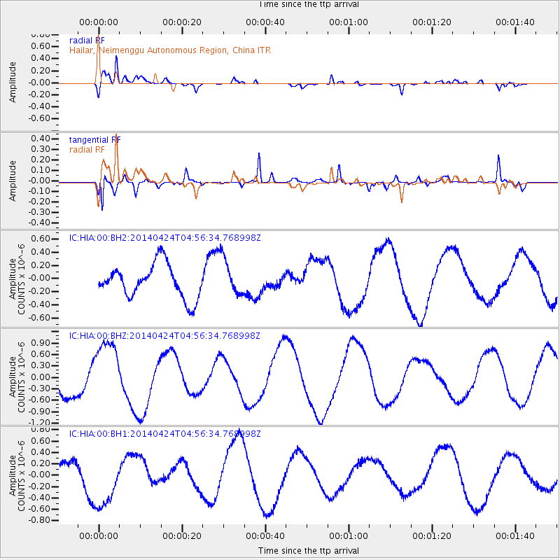
HIA Hailar, Neimenggu Autonomous Region, China - Earthquake Result Viewer
*The percent match for this event was below the threshold and hence no stack was calculated.
| Earthquake location: |
Mindanao, Philippines |
| Earthquake latitude/longitude: |
9.7/126.3 |
| Earthquake time(UTC): |
2014/04/24 (114) 04:49:38 GMT |
| Earthquake Depth: |
63 km |
| Earthquake Magnitude: |
4.7 mb |
| Earthquake Catalog/Contributor: |
ISC/ISC |
|
| Network: |
IC New China Digital Seismograph Network |
| Station: |
HIA Hailar, Neimenggu Autonomous Region, China |
| Lat/Lon: |
49.27 N/119.74 E |
| Elevation: |
620 m |
|
| Distance: |
39.8 deg |
| Az: |
353.329 deg |
| Baz: |
169.931 deg |
| Ray Param: |
$rayparam |
*The percent match for this event was below the threshold and hence was not used in the summary stack. |
|
| Radial Match: |
74.306496 % |
| Radial Bump: |
400 |
| Transverse Match: |
82.50373 % |
| Transverse Bump: |
340 |
| SOD ConfigId: |
3390531 |
| Insert Time: |
2019-04-11 14:37:19.038 +0000 |
| GWidth: |
2.5 |
| Max Bumps: |
400 |
| Tol: |
0.001 |
|
Signal To Noise
| Channel | StoN | STA | LTA |
| IC:HIA:00:BHZ:20140424T04:56:34.768998Z | 2.1313992 | 8.711354E-7 | 4.087153E-7 |
| IC:HIA:00:BH1:20140424T04:56:34.768998Z | 2.4150274 | 4.7108884E-7 | 1.9506564E-7 |
| IC:HIA:00:BH2:20140424T04:56:34.768998Z | 1.1166269 | 2.8286604E-7 | 2.533219E-7 |
| Arrivals |
| Ps | |
| PpPs | |
| PsPs/PpSs | |


