You are here: Home > Network List > XB14 - Sweetwater Array Stations List
> Station C0202 991020 > Earthquake Result Viewer
C0202 991020 - Earthquake Result Viewer
| Earthquake location: |
Tonga Islands |
| Earthquake latitude/longitude: |
-20.7/-174.7 |
| Earthquake time(UTC): |
2014/04/26 (116) 06:02:16 GMT |
| Earthquake Depth: |
10 km |
| Earthquake Magnitude: |
6.5 MWP |
| Earthquake Catalog/Contributor: |
NEIC PDE/NEIC COMCAT |
|
| Network: |
XB Sweetwater Array |
| Station: |
C0202 991020 |
| Lat/Lon: |
32.76 N/100.46 W |
| Elevation: |
570 m |
|
| Distance: |
88.6 deg |
| Az: |
54.198 deg |
| Baz: |
244.301 deg |
| Ray Param: |
0.04250002 |
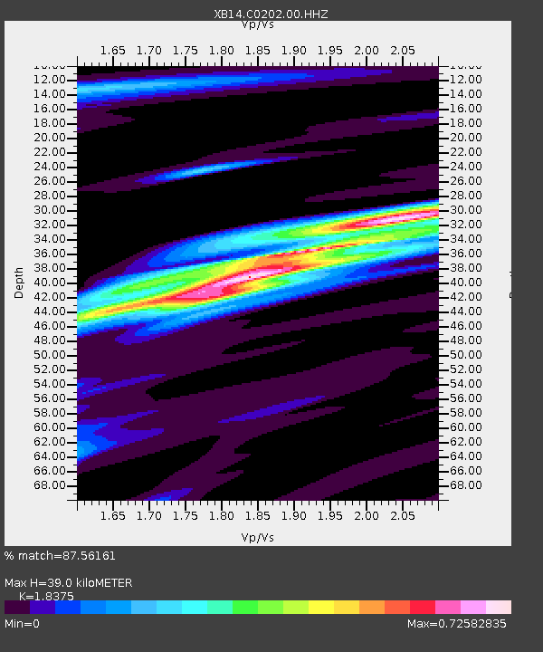
| Estimated Moho Depth: |
39.0 km |
| Estimated Crust Vp/Vs: |
1.84 |
| Assumed Crust Vp: |
6.426 km/s |
| Estimated Crust Vs: |
3.497 km/s |
| Estimated Crust Poisson's Ratio: |
0.29 |
|
| Radial Match: |
87.56161 % |
| Radial Bump: |
325 |
| Transverse Match: |
68.60239 % |
| Transverse Bump: |
400 |
| SOD ConfigId: |
3390531 |
| Insert Time: |
2019-04-11 15:00:29.559 +0000 |
| GWidth: |
2.5 |
| Max Bumps: |
400 |
| Tol: |
0.001 |
|

Signal To Noise
| Channel | StoN | STA | LTA |
| XB:C0202:00:HHZ:20140426T06:14:37.53501Z | 25.734684 | 4.7522376E-6 | 1.8466274E-7 |
| XB:C0202:00:HH1:20140426T06:14:37.53501Z | 3.7206192 | 5.218048E-7 | 1.4024677E-7 |
| XB:C0202:00:HH2:20140426T06:14:37.53501Z | 8.709239 | 1.1682054E-6 | 1.3413404E-7 |
| Arrivals |
| Ps | 5.2 SECOND |
| PpPs | 17 SECOND |
| PsPs/PpSs | 22 SECOND |


