
Station XB C0202 - 991020
Network: XB14 - Sweetwater Array
Nearby stations (2 deg radius)
| Station | Name | (Lat, Lon) | Start / End | Elevation |
| C0202 | 991020 | (32.76, -100.46) | 2014-03-07 / 2014-05-01 | 570 m |
| Crust2 Type: | D8,thick Platform 3 km seds. |
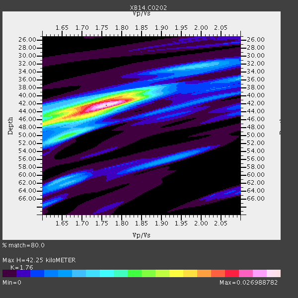
| Thickness Estimate: | 42 km |
| Thickness StdDev: | 4.7 km |
| Vp/Vs Estimate: | 1.76 |
| Vp/Vs StdDev: | 0.09 |
| Vs Estimate: | 3.651 km/s |
| Poisson's Ratio: | 0.26 |
| Peak Value: | 0.03 |
| Assumed Vp: | 6.426 km/s |
| Ps Weight: | 0.33333334 |
| PpPs Weight: | 0.33333334 |
| PsPs Weight: | 0.33333328 |
| Residual Complexity: | 0.582 |
| Nearby stations H: | 45 km +- 1.4 km |
| (2.0 deg) Vp/Vs: | 1.65 +- 0.05 |
1 with match > 90% ( 3.4482758 %) and 4 with match > 80% ( 13.793103 %) out of 29.
Download stack as xyz text file.
Azimuth Distribution of Events:

Prior Results for this Station
| Study | Thickness | Vp/Vs | Vp | Vs | Poissons Ratio | Extra |
| EARS | 42 km | 1.76 | 6.426 km/s | 3.651 km/s | 0.26 | |
| Crust2.0 | 46 km | 1.78 | 6.426 km/s | 3.613 km/s | 0.27 | D8,thick Platform 3 km seds. |
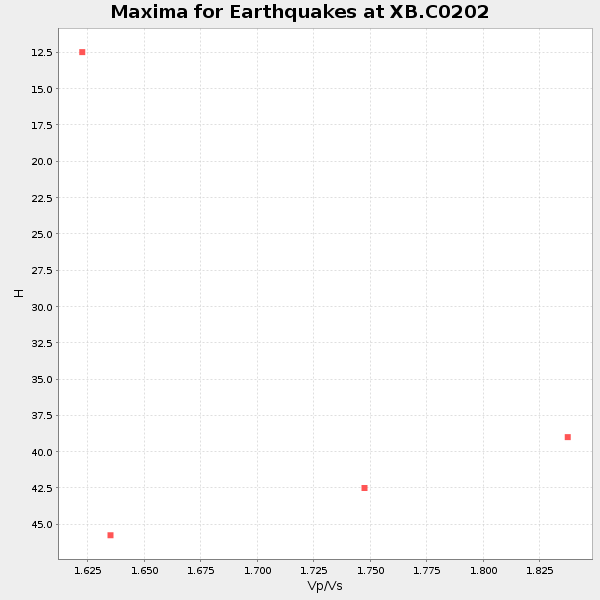
| Global Maxima | 42 km | 1.76 | 6.426 km/s | 3.651 km/s | 0.26 | amp=0.026988782 |
| Local Maxima 1 | 47 km | 1.61 | 6.426 km/s | 3.991 km/s | 0.19 | amp=0.01589568 |
| Local Maxima 2 | 40 km | 1.77 | 6.426 km/s | 3.62 km/s | 0.27 | amp=0.014283894 |
| Local Maxima 3 | 61 km | 1.65 | 6.426 km/s | 3.883 km/s | 0.21 | amp=0.008745163 |
| Local Maxima 4 | 50 km | 1.68 | 6.426 km/s | 3.836 km/s | 0.22 | amp=0.0071815993 |
| Predicted Arrivals for vertical incidence (zero ray parameter) | |
| Ps | 5.00 SECOND |
| PpPs | 18.15 SECOND |
| PsPs/PpSs | 23.14 SECOND |
Events Processed for this Station
Download zip of receiver functions as SAC
Plot maxima for each earthquake.
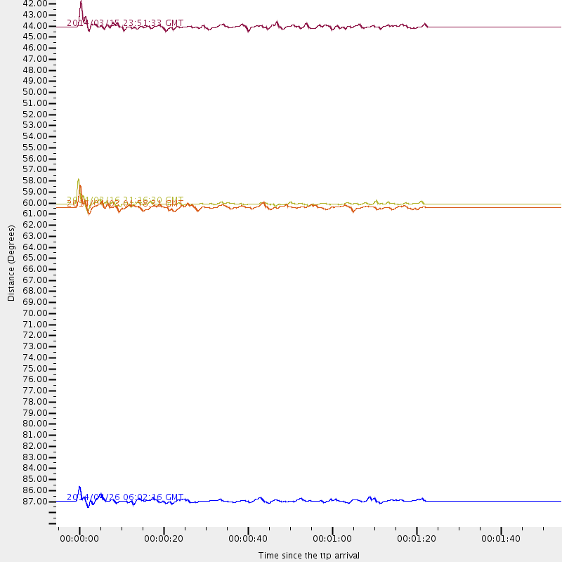
Events Used in the Stack
(4 events)| Radial Match | Distance | Baz | FERegion | Time | Lat/Lon | Depth | Magnitude |
| 96.08839 | 59.7 deg | 147.151 deg | Near Coast Of Northern Chile | 2014/03/16 21:16:30 GMT | (-19.9, -70.6) | 20 km | 6.7 MWW, 6.7 MWC, 7.0 MI |
| 87.56161 | 88.6 deg | 244.301 deg | Tonga Islands | 2014/04/26 06:02:16 GMT | (-20.7, -174.7) | 10 km | 6.5 MWP |
| 86.90056 | 60.0 deg | 147.275 deg | Near Coast Of Northern Chile | 2014/04/03 01:58:31 GMT | (-20.3, -70.6) | 23 km | 6.5 MWW, 6.5 MWB, 6.6 MWC |
| 81.20776 | 42.4 deg | 150.467 deg | Near Coast Of Northern Peru | 2014/03/15 23:51:33 GMT | (-5.6, -81.0) | 29 km | 6.3 MWW, 6.2 MWB, 6.3 MWC |
Losers
(25 events)| Radial Match | Distance | Baz | FERegion | Time | Lat/Lon | Depth | Magnitude | Reason |
| 99.11475 | 59.3 deg | 147.174 deg | Near Coast Of Northern Chile | 2014/04/01 23:46:46 GMT | (-19.6, -70.8) | 20 km | 8.2 MWW, 8.0 MI, 8.1 MWC | |
| 96.19754 | 60.2 deg | 147.359 deg | Near Coast Of Northern Chile | 2014/04/03 02:43:14 GMT | (-20.5, -70.5) | 31 km | 7.7 MWW, 7.4 MI, 7.7 MWC | |
| 79.82916 | 60.2 deg | 147.645 deg | Near Coast Of Northern Chile | 2014/04/04 01:37:51 GMT | (-20.6, -70.7) | 20 km | 6.1 MWP, 6.1 MWB, 6.1 MWW, 6.3 MWC | |
| 79.58799 | 59.4 deg | 147.225 deg | Near Coast Of Northern Chile | 2014/03/23 18:20:03 GMT | (-19.7, -70.8) | 35 km | 6.0 MB, 6.2 MWB, 6.2 MWW, 6.3 MWC | |
| 79.22972 | 60.2 deg | 147.646 deg | Near Coast Of Northern Chile | 2014/04/03 03:11:14 GMT | (-20.6, -70.7) | 10 km | 5.8 MB | |
| 72.82407 | 52.0 deg | 149.747 deg | Near Coast Of Peru | 2014/03/15 08:59:21 GMT | (-14.1, -76.3) | 20 km | 6.1 MWW, 6.0 MWB, 6.2 MWC | |
| 72.58967 | 60.3 deg | 147.7 deg | Near Coast Of Northern Chile | 2014/04/11 00:01:44 GMT | (-20.7, -70.7) | 18 km | 6.0 MB | |
| 68.90029 | 90.5 deg | 242.47 deg | Tonga Islands Region | 2014/03/14 22:49:56 GMT | (-23.4, -175.3) | 14 km | 5.1 MW | |
| 68.06577 | 59.6 deg | 147.321 deg | Near Coast Of Northern Chile | 2014/03/18 21:26:45 GMT | (-20.0, -70.8) | 3.8 km | 5.8 MWW, 5.9 MWC, 6.0 MWR, 6.0 MWB | |
| 66.990326 | 59.7 deg | 147.509 deg | Near Coast Of Northern Chile | 2014/04/07 13:43:20 GMT | (-20.2, -70.9) | 7.9 km | 5.8 MWB, 5.7 MWW, 5.7 MWC | |
| 66.41297 | 59.5 deg | 146.468 deg | Near Coast Of Northern Chile | 2014/04/01 23:59:57 GMT | (-19.5, -70.2) | 22 km | 5.8 MB | |
| 64.47443 | 96.2 deg | 310.584 deg | Southeast Of Honshu, Japan | 2014/03/22 14:18:47 GMT | (29.3, 139.4) | 425 km | 5.4 mb | |
| 64.34386 | 59.9 deg | 147.747 deg | Near Coast Of Northern Chile | 2014/04/06 14:06:09 GMT | (-20.4, -71.0) | 20 km | 5.3 MW | |
| 61.223835 | 49.6 deg | 333.72 deg | Northern Alaska | 2014/04/18 18:56:47 GMT | (67.7, -162.5) | 17 km | 5.7 MW | |
| 58.69314 | 73.1 deg | 319.389 deg | Kuril Islands | 2014/04/07 09:34:49 GMT | (50.4, 156.3) | 85 km | 5.2 MW | |
| 57.386494 | 49.6 deg | 333.675 deg | Northern Alaska | 2014/04/18 18:44:17 GMT | (67.7, -162.5) | 1.0 km | 5.5 MB, 5.4 MI | |
| 56.691425 | 60.0 deg | 147.754 deg | Near Coast Of Northern Chile | 2014/04/08 10:14:32 GMT | (-20.5, -70.9) | 7.1 km | 5.7 MWB, 5.5 MWR, 5.6 MWC, 5.6 MWW | |
| 55.858498 | 96.2 deg | 243.055 deg | South Of Fiji Islands | 2014/03/26 03:29:36 GMT | (-26.1, 179.3) | 493 km | 6.5 MWP, 6.3 MWW, 6.3 MWC, 6.4 MWB, 6.4 MWC, 6.5 MI | |
| 54.864826 | 59.3 deg | 147.153 deg | Near Coast Of Northern Chile | 2014/03/24 15:45:31 GMT | (-19.6, -70.8) | 18 km | 5.6 MWB, 5.5 MWR, 5.7 MWC, 5.7 MWW | |
| 54.81963 | 59.8 deg | 147.492 deg | Near Coast Of Northern Chile | 2014/04/02 04:46:18 GMT | (-20.2, -70.9) | 10 km | 5.8 MB | |
| 54.632862 | 59.8 deg | 147.406 deg | Near Coast Of Northern Chile | 2014/04/15 16:21:17 GMT | (-20.2, -70.7) | 18 km | 5.1 MW | |
| 51.339756 | 60.0 deg | 145.547 deg | Northern Chile | 2014/03/31 12:53:05 GMT | (-19.5, -69.2) | 112 km | 5.6 MB, 5.5 MWB, 5.6 MWC, 5.6 MWW | |
| 46.100834 | 59.5 deg | 147.227 deg | Near Coast Of Northern Chile | 2014/03/24 11:32:15 GMT | (-19.8, -70.8) | 24 km | 5.3 MW | |
| 41.980045 | 70.7 deg | 154.462 deg | Near Coast Of Central Chile | 2014/04/05 02:22:38 GMT | (-32.8, -71.6) | 40 km | 5.6 MWC, 5.6 MWC | |
| 36.47911 | 70.0 deg | 144.814 deg | Santiago Del Estero Prov., Arg. | 2014/04/18 07:46:57 GMT | (-27.7, -62.8) | 610 km | 5.6 MW |

