You are here: Home > Network List > IC - New China Digital Seismograph Network Stations List
> Station HIA Hailar, Neimenggu Province, China > Earthquake Result Viewer
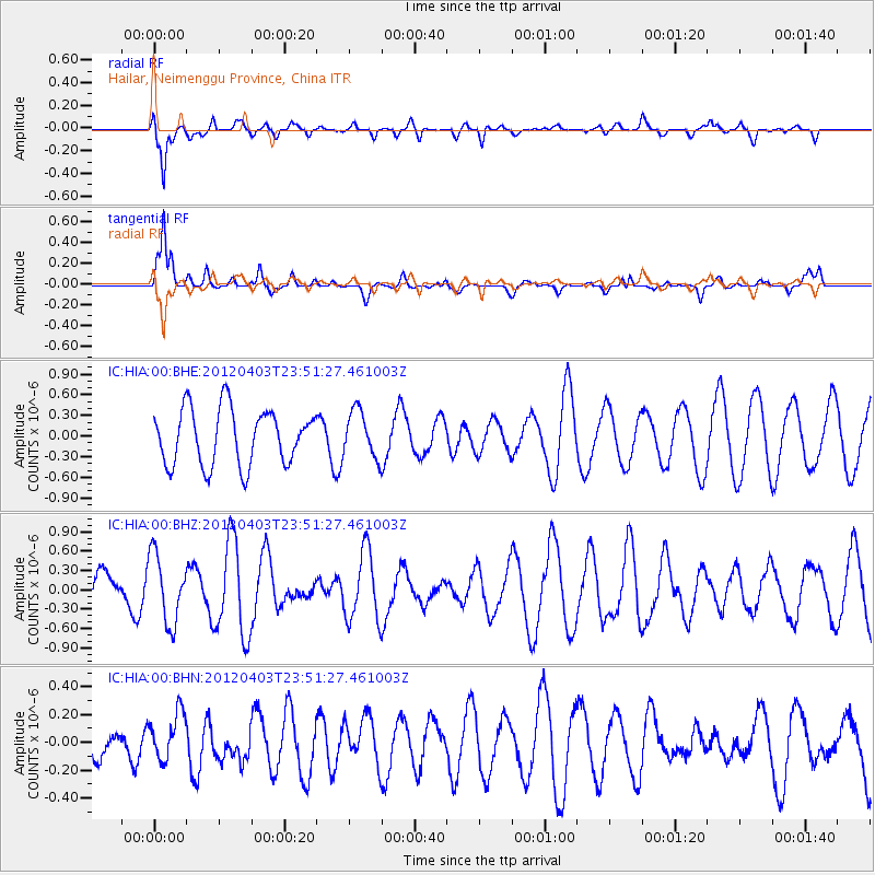
HIA Hailar, Neimenggu Province, China - Earthquake Result Viewer
*The percent match for this event was below the threshold and hence no stack was calculated.
| Earthquake location: |
Aru Islands Region, Indonesia |
| Earthquake latitude/longitude: |
-5.7/133.9 |
| Earthquake time(UTC): |
2012/04/03 (094) 23:42:19 GMT |
| Earthquake Depth: |
10 km |
| Earthquake Magnitude: |
5.7 MB, 5.0 MS, 5.4 MW |
| Earthquake Catalog/Contributor: |
WHDF/NEIC |
|
| Network: |
IC New China Digital Seismograph Network |
| Station: |
HIA Hailar, Neimenggu Province, China |
| Lat/Lon: |
49.27 N/119.74 E |
| Elevation: |
620 m |
|
| Distance: |
56.1 deg |
| Az: |
348.885 deg |
| Baz: |
162.968 deg |
| Ray Param: |
$rayparam |
*The percent match for this event was below the threshold and hence was not used in the summary stack. |
|
| Radial Match: |
78.481834 % |
| Radial Bump: |
400 |
| Transverse Match: |
75.78537 % |
| Transverse Bump: |
400 |
| SOD ConfigId: |
445498 |
| Insert Time: |
2012-06-23 05:32:40.707 +0000 |
| GWidth: |
2.5 |
| Max Bumps: |
400 |
| Tol: |
0.001 |
|
Signal To Noise
| Channel | StoN | STA | LTA |
| IC:HIA:00:BHZ:20120403T23:51:27.461003Z | 1.6721488 | 5.275363E-7 | 3.1548407E-7 |
| IC:HIA:00:BHN:20120403T23:51:27.461003Z | 0.81240875 | 1.7004379E-7 | 2.0930817E-7 |
| IC:HIA:00:BHE:20120403T23:51:27.461003Z | 0.8353127 | 3.3816E-7 | 4.0483042E-7 |
| Arrivals |
| Ps | |
| PpPs | |
| PsPs/PpSs | |


