You are here: Home > Network List > IC - New China Digital Seismograph Network Stations List
> Station HIA Hailar, Neimenggu Province, China > Earthquake Result Viewer
HIA Hailar, Neimenggu Province, China - Earthquake Result Viewer
| Earthquake location: |
Off W Coast Of Northern Sumatra |
| Earthquake latitude/longitude: |
2.3/93.1 |
| Earthquake time(UTC): |
2012/04/11 (102) 08:38:36 GMT |
| Earthquake Depth: |
20 km |
| Earthquake Magnitude: |
7.4 MB, 8.5 MS, 8.6 MW, 8.6 MW |
| Earthquake Catalog/Contributor: |
WHDF/NEIC |
|
| Network: |
IC New China Digital Seismograph Network |
| Station: |
HIA Hailar, Neimenggu Province, China |
| Lat/Lon: |
49.27 N/119.74 E |
| Elevation: |
620 m |
|
| Distance: |
52.0 deg |
| Az: |
21.904 deg |
| Baz: |
214.686 deg |
| Ray Param: |
0.06699874 |
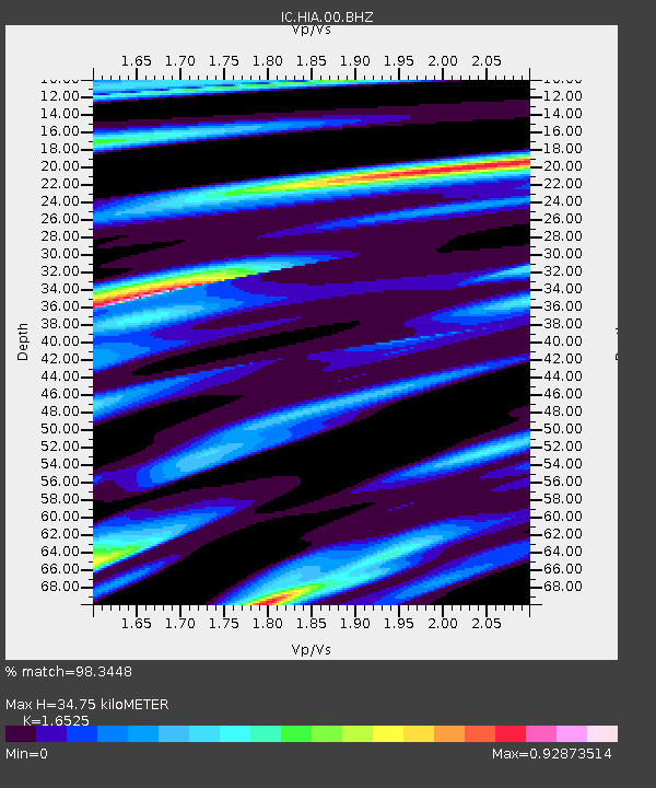
| Estimated Moho Depth: |
34.75 km |
| Estimated Crust Vp/Vs: |
1.65 |
| Assumed Crust Vp: |
6.577 km/s |
| Estimated Crust Vs: |
3.98 km/s |
| Estimated Crust Poisson's Ratio: |
0.21 |
|
| Radial Match: |
98.3448 % |
| Radial Bump: |
306 |
| Transverse Match: |
93.16094 % |
| Transverse Bump: |
400 |
| SOD ConfigId: |
446234 |
| Insert Time: |
2012-07-04 09:22:50.647 +0000 |
| GWidth: |
2.5 |
| Max Bumps: |
400 |
| Tol: |
0.001 |
|

Signal To Noise
| Channel | StoN | STA | LTA |
| IC:HIA:00:BHZ:20120411T08:47:13.886992Z | 5.636008 | 1.0519938E-6 | 1.8665585E-7 |
| IC:HIA:00:BHN:20120411T08:47:13.886992Z | 2.8357239 | 5.8539734E-7 | 2.0643665E-7 |
| IC:HIA:00:BHE:20120411T08:47:13.886992Z | 4.3076334 | 4.4630957E-7 | 1.03609E-7 |
| Arrivals |
| Ps | 3.7 SECOND |
| PpPs | 13 SECOND |
| PsPs/PpSs | 17 SECOND |


