You are here: Home > Network List > TA - USArray Transportable Network (new EarthScope stations) Stations List
> Station 457A Yulee, FL, USA > Earthquake Result Viewer
457A Yulee, FL, USA - Earthquake Result Viewer
| Earthquake location: |
Peru-Bolivia Border Region |
| Earthquake latitude/longitude: |
-17.7/-69.6 |
| Earthquake time(UTC): |
2012/05/14 (135) 10:00:40 GMT |
| Earthquake Depth: |
106 km |
| Earthquake Magnitude: |
6.4 MB, 6.2 MW, 6.2 MW |
| Earthquake Catalog/Contributor: |
WHDF/NEIC |
|
| Network: |
TA USArray Transportable Network (new EarthScope stations) |
| Station: |
457A Yulee, FL, USA |
| Lat/Lon: |
30.62 N/81.56 W |
| Elevation: |
16 m |
|
| Distance: |
49.4 deg |
| Az: |
346.382 deg |
| Baz: |
164.907 deg |
| Ray Param: |
0.06839482 |
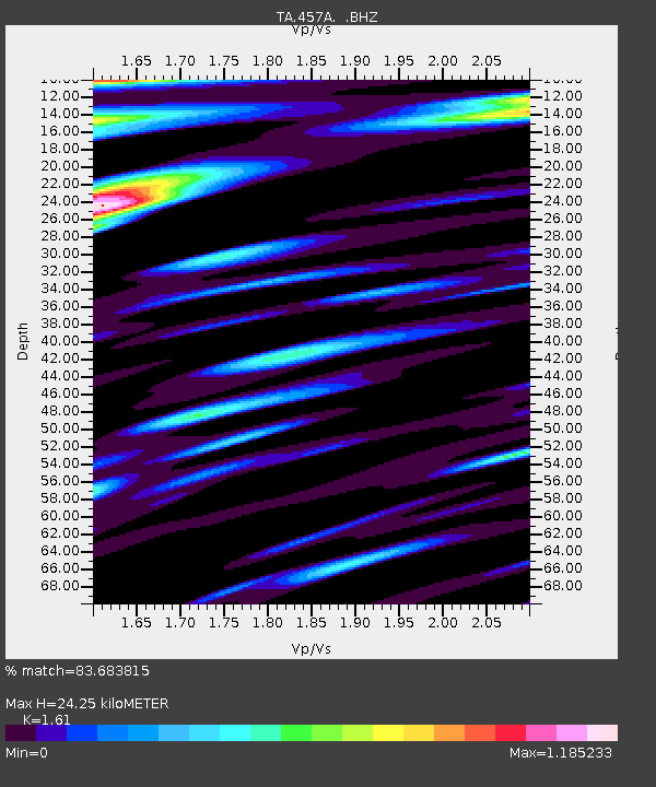
| Estimated Moho Depth: |
24.25 km |
| Estimated Crust Vp/Vs: |
1.61 |
| Assumed Crust Vp: |
5.989 km/s |
| Estimated Crust Vs: |
3.72 km/s |
| Estimated Crust Poisson's Ratio: |
0.19 |
|
| Radial Match: |
83.683815 % |
| Radial Bump: |
400 |
| Transverse Match: |
71.43994 % |
| Transverse Bump: |
400 |
| SOD ConfigId: |
446234 |
| Insert Time: |
2012-08-08 22:45:06.823 +0000 |
| GWidth: |
2.5 |
| Max Bumps: |
400 |
| Tol: |
0.001 |
|

Signal To Noise
| Channel | StoN | STA | LTA |
| TA:457A: :BHZ:20120514T10:08:48.525013Z | 9.5549755 | 5.992086E-6 | 6.2711683E-7 |
| TA:457A: :BHN:20120514T10:08:48.525013Z | 2.964764 | 2.8342545E-6 | 9.559798E-7 |
| TA:457A: :BHE:20120514T10:08:48.525013Z | 1.555281 | 1.3240617E-6 | 8.513328E-7 |
| Arrivals |
| Ps | 2.6 SECOND |
| PpPs | 10.0 SECOND |
| PsPs/PpSs | 13 SECOND |


