
Station TA 457A - Yulee, FL, USA
Network: TA - USArray Transportable Network (new EarthScope stations)
Nearby stations (2 deg radius)
| Station | Name | (Lat, Lon) | Start / End | Elevation |
| 457A | Yulee, FL, USA | (30.62, -81.56) | 2012-02-03 / 2599-12-31 | 16 m |
| Crust2 Type: | C4,continental shelf, 3.5 km seds. |
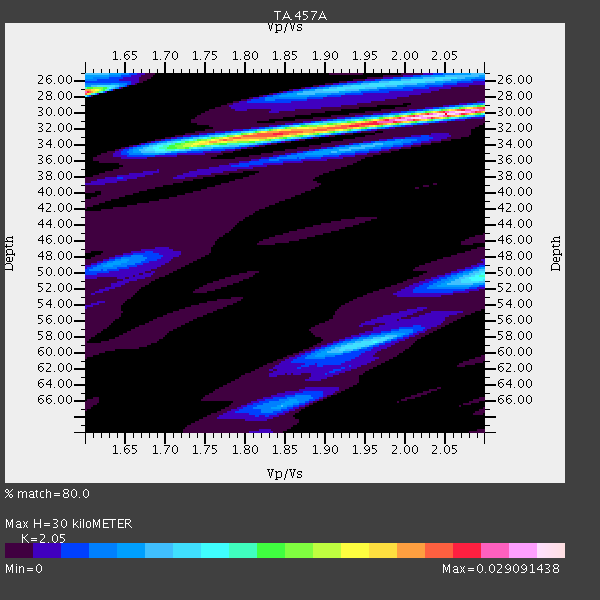
| Thickness Estimate: | 30 km |
| Thickness StdDev: | 3.4 km |
| Vp/Vs Estimate: | 2.05 |
| Vp/Vs StdDev: | 0.16 |
| Vs Estimate: | 2.921 km/s |
| Poisson's Ratio: | 0.34 |
| Peak Value: | 0.03 |
| Assumed Vp: | 5.989 km/s |
| Ps Weight: | 0.33333334 |
| PpPs Weight: | 0.33333334 |
| PsPs Weight: | 0.33333328 |
| Residual Complexity: | 0.616 |
| Nearby stations H: | +- |
| (2.0 deg) Vp/Vs: | +- |
6 with match > 90% ( 22.222221 %) and 11 with match > 80% ( 40.74074 %) out of 27.
Download stack as xyz text file.
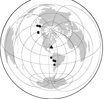
Azimuth Distribution of Events:
Prior Results for this Station
| Study | Thickness | Vp/Vs | Vp | Vs | Poissons Ratio | Extra |
| EARS | 30 km | 2.05 | 5.989 km/s | 2.921 km/s | 0.34 | |
| Crust2.0 | 32 km | 1.81 | 5.989 km/s | 3.317 km/s | 0.28 | C4,continental shelf, 3.5 km seds. |
| Global Maxima | 30 km | 2.05 | 5.989 km/s | 2.921 km/s | 0.34 | amp=0.029091438 |
| Local Maxima 1 | 27 km | 1.60 | 5.989 km/s | 3.743 km/s | 0.18 | amp=0.024805548 |
| Local Maxima 2 | 33 km | 1.83 | 5.989 km/s | 3.273 km/s | 0.29 | amp=0.018474108 |
| Local Maxima 3 | 50 km | 2.10 | 5.989 km/s | 2.855 km/s | 0.35 | amp=0.012100331 |
| Local Maxima 4 | 27 km | 1.90 | 5.989 km/s | 3.144 km/s | 0.31 | amp=0.007813979 |
| Predicted Arrivals for vertical incidence (zero ray parameter) | |
| Ps | 5.26 SECOND |
| PpPs | 15.28 SECOND |
| PsPs/PpSs | 20.54 SECOND |
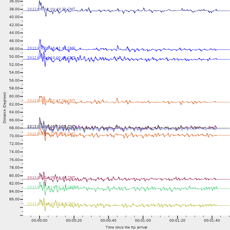
Events Processed for this Station
Download zip of receiver functions as SAC
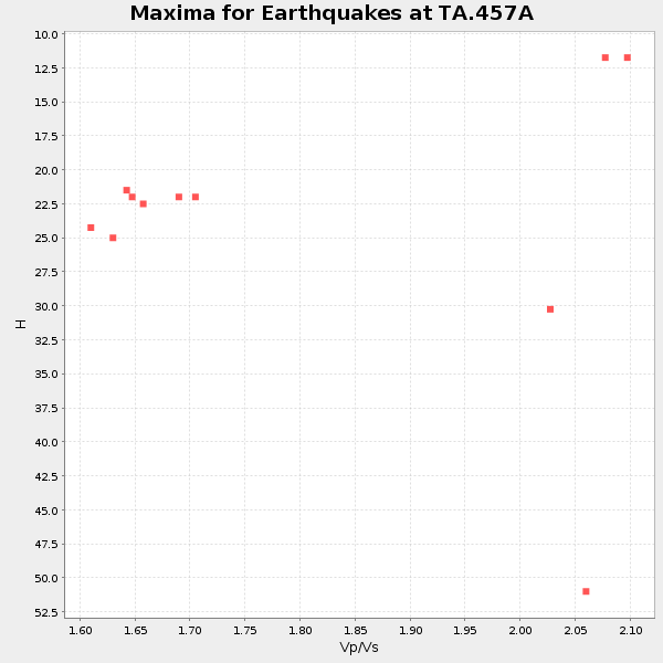
Plot maxima for each earthquake.
Events Used in the Stack
(11 events)| Radial Match | Distance | Baz | FERegion | Time | Lat/Lon | Depth | Magnitude |
| 96.664314 | 82.7 deg | 331.591 deg | Sea Of Okhotsk | 2013/05/24 05:44:48 GMT | (54.9, 153.2) | 598 km | 8.4 MW, 7.5 MB, 8.3 MW |
| 95.70799 | 46.7 deg | 170.662 deg | Near Coast Of Peru | 2013/09/25 16:42:43 GMT | (-15.8, -74.5) | 40 km | 7.1 MWW, 6.8 MI, 7.0 MWB, 7.0 MWC, 7.1 MWW, 7.1 MWC |
| 95.258224 | 90.1 deg | 326.655 deg | Kuril Islands | 2013/04/19 03:05:52 GMT | (46.2, 150.8) | 110 km | 7.2 MW, 7.1 MB, 7.2 MW |
| 93.07205 | 68.5 deg | 317.955 deg | Andreanof Islands, Aleutian Is. | 2013/09/04 02:32:30 GMT | (51.6, -174.8) | 20 km | 6.5 MWW, 5.9 ML, 6.3 MWB, 6.5 MI, 6.5 MWC, 6.5 MWW |
| 92.35641 | 68.8 deg | 318.053 deg | Andreanof Islands, Aleutian Is. | 2013/08/30 16:25:02 GMT | (51.5, -175.2) | 29 km | 7.0 MWW, 6.5 ML, 6.8 MI, 6.9 MWC, 6.9 MWB, 7.0 MWW, 7.0 MI, 7.0 MWC |
| 90.34912 | 85.4 deg | 330.478 deg | Sea Of Okhotsk | 2013/05/24 14:56:31 GMT | (52.2, 151.4) | 624 km | 6.7 MW, 6.7 MB, 6.7 MW |
| 89.30841 | 35.8 deg | 180.63 deg | Near Coast Of Northern Peru | 2013/08/12 09:49:32 GMT | (-5.4, -81.9) | 10 km | 6.2 MWW, 6.1 MWB, 6.2 MWW, 6.2 MWC, 6.3 MWC |
| 84.09442 | 70.5 deg | 318.928 deg | Andreanof Islands, Aleutian Is. | 2012/09/26 23:39:55 GMT | (51.6, -178.3) | 16 km | 6.3 MB, 6.5 MS, 6.4 MW, 6.4 MW |
| 83.683815 | 49.4 deg | 164.907 deg | Peru-Bolivia Border Region | 2012/05/14 10:00:40 GMT | (-17.7, -69.6) | 106 km | 6.4 MB, 6.2 MW, 6.2 MW |
| 82.06668 | 68.5 deg | 317.959 deg | Andreanof Islands, Aleutian Is. | 2013/09/15 16:21:37 GMT | (51.6, -174.7) | 24 km | 6.1 MWW, 5.7 MI, 5.7 ML, 6.0 MWB, 6.1 MWC, 6.1 MWW |
| 82.00364 | 61.3 deg | 170.109 deg | Near Coast Of Central Chile | 2013/10/31 23:03:59 GMT | (-30.3, -71.5) | 27 km | 6.6 MWW, 6.4 MWB, 6.5 MWC, 6.6 MWW, 6.6 MI |
Losers
(16 events)| Radial Match | Distance | Baz | FERegion | Time | Lat/Lon | Depth | Magnitude | Reason |
| 89.25513 | 87.5 deg | 164.035 deg | South Atlantic Ocean | 2013/11/25 07:21:18 GMT | (-53.9, -53.9) | 15 km | 6.0 MWC, 6.0 MWC | |
| 78.61584 | 84.1 deg | 330.567 deg | Sea Of Okhotsk | 2013/10/01 03:38:21 GMT | (53.2, 152.8) | 573 km | 6.7 MWW, 6.7 MWC, 6.8 MWC, 6.8 MWB | |
| 78.52581 | 53.6 deg | 164.484 deg | Chile-Bolivia Border Region | 2012/10/08 01:50:26 GMT | (-21.7, -68.2) | 122 km | 6.0 MB, 5.7 MW, 5.8 MW | |
| 76.77863 | 36.6 deg | 106.542 deg | Northern Mid-Atlantic Ridge | 2013/09/05 04:01:36 GMT | (15.2, -45.2) | 10 km | 6.0 MWW, 5.9 MWB, 6.0 MWW, 6.0 MWC | |
| 71.78023 | 68.5 deg | 317.814 deg | Andreanof Islands, Aleutian Is. | 2013/09/05 05:43:39 GMT | (51.5, -174.6) | 20 km | 5.6 MWW, 5.4 MI, 5.5 MWB, 5.6 MWW, 5.7 MWC, 5.7 ML, 5.8 MWC | |
| 71.42545 | 83.6 deg | 326.955 deg | Kuril Islands | 2013/03/01 13:20:49 GMT | (51.0, 157.4) | 29 km | 6.3 MB, 6.3 MS, 6.5 MW, 6.4 MW | |
| 70.6464 | 76.6 deg | 344.121 deg | Eastern Siberia, Russia | 2013/02/14 13:13:53 GMT | (67.6, 142.5) | 11 km | 6.5 MB, 6.7 MS, 6.6 MW, 6.7 MW | |
| 67.07418 | 78.9 deg | 327.917 deg | Near East Coast Of Kamchatka | 2013/11/12 07:03:51 GMT | (54.7, 162.3) | 43 km | 6.4 MWW, 6.3 MWC, 6.4 MWW, 6.4 MWB, 6.5 MWC, 6.6 MI | |
| 62.246758 | 81.4 deg | 326.914 deg | Off East Coast Of Kamchatka | 2013/05/19 18:44:10 GMT | (52.3, 160.1) | 18 km | 6.1 MW, 5.8 MS, 5.9 MB, 5.9 MW | |
| 61.238506 | 83.7 deg | 327.005 deg | Kuril Islands | 2013/02/28 14:05:50 GMT | (51.0, 157.3) | 41 km | 6.4 MB, 6.7 MS, 6.9 MW, 6.8 MW | |
| 60.843616 | 82.4 deg | 325.629 deg | East Of Kuril Islands | 2013/03/24 04:18:33 GMT | (50.7, 160.2) | 8.0 km | 6.1 MB, 5.5 MS, 5.9 MW, 6.1 MW | |
| 60.39711 | 81.0 deg | 326.883 deg | Off East Coast Of Kamchatka | 2013/05/21 14:51:19 GMT | (52.6, 160.6) | 37 km | 5.6 MW, 5.5 MW | |
| 59.26745 | 35.3 deg | 170.567 deg | Northern Peru | 2012/11/28 03:09:48 GMT | (-4.5, -76.1) | 118 km | 5.9 MB, 5.6 MW, 5.7 MW | |
| 48.122 | 60.8 deg | 161.287 deg | Santiago Del Estero Prov., Arg. | 2013/02/22 12:01:58 GMT | (-27.9, -63.1) | 575 km | 5.8 MB, 6.1 MW, 6.2 MW | |
| 44.421986 | 57.0 deg | 168.165 deg | Near Coast Of Northern Chile | 2012/05/19 08:35:10 GMT | (-25.7, -70.6) | 28 km | 5.7 MB, 5.5 MS, 5.8 MW, 5.9 MW | |
| 38.450226 | 57.6 deg | 167.097 deg | Northern Chile | 2013/05/12 12:59:10 GMT | (-26.2, -69.4) | 10 km | 5.5 MB, 4.7 MS, 5.4 MW, 5.1 ML |
