You are here: Home > Network List > TA - USArray Transportable Network (new EarthScope stations) Stations List
> Station 658A Bunnell, FL, USA > Earthquake Result Viewer
658A Bunnell, FL, USA - Earthquake Result Viewer

| Earthquake location: |
Peru-Bolivia Border Region |
| Earthquake latitude/longitude: |
-17.7/-69.6 |
| Earthquake time(UTC): |
2012/05/14 (135) 10:00:40 GMT |
| Earthquake Depth: |
106 km |
| Earthquake Magnitude: |
6.4 MB, 6.2 MW, 6.2 MW |
| Earthquake Catalog/Contributor: |
WHDF/NEIC |
|
| Network: |
TA USArray Transportable Network (new EarthScope stations) |
| Station: |
658A Bunnell, FL, USA |
| Lat/Lon: |
29.42 N/81.26 W |
| Elevation: |
11 m |
|
| Distance: |
48.2 deg |
| Az: |
346.302 deg |
| Baz: |
165.003 deg |
| Ray Param: |
0.06918217 |
| Estimated Moho Depth: |
13.5 km |
| Estimated Crust Vp/Vs: |
1.60 |
| Assumed Crust Vp: |
6.134 km/s |
| Estimated Crust Vs: |
3.834 km/s |
| Estimated Crust Poisson's Ratio: |
0.18 |
|
| Radial Match: |
91.78629 % |
| Radial Bump: |
400 |
| Transverse Match: |
68.65226 % |
| Transverse Bump: |
400 |
| SOD ConfigId: |
446234 |
| Insert Time: |
2012-08-08 22:46:17.912 +0000 |
| GWidth: |
2.5 |
| Max Bumps: |
400 |
| Tol: |
0.001 |
|
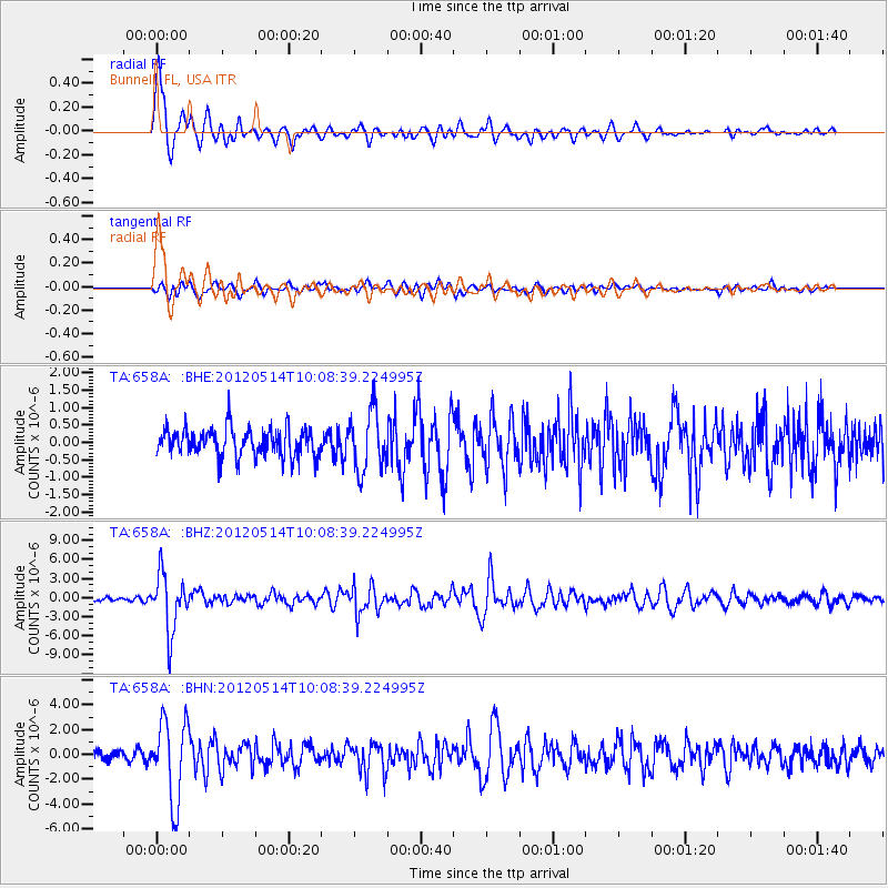
Signal To Noise
| Channel | StoN | STA | LTA |
| TA:658A: :BHZ:20120514T10:08:39.224995Z | 15.860081 | 4.462948E-6 | 2.8139502E-7 |
| TA:658A: :BHN:20120514T10:08:39.224995Z | 10.1719885 | 3.21449E-6 | 3.160139E-7 |
| TA:658A: :BHE:20120514T10:08:39.224995Z | 2.1093614 | 8.5458663E-7 | 4.0513999E-7 |
| Arrivals |
| Ps | 1.4 SECOND |
| PpPs | 5.4 SECOND |
| PsPs/PpSs | 6.8 SECOND |


