
Station TA 658A - Bunnell, FL, USA
Network: TA - USArray Transportable Network (new EarthScope stations)
Nearby stations (2 deg radius)
| Station | Name | (Lat, Lon) | Start / End | Elevation |
| 658A | Bunnell, FL, USA | (29.42, -81.26) | 2012-02-07 / 2599-12-31 | 11 m |
| Crust2 Type: | C3,continental shelf, 2 km seds. |
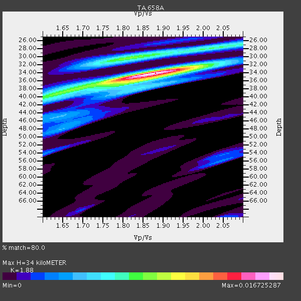
| Thickness Estimate: | 34 km |
| Thickness StdDev: | 3.7 km |
| Vp/Vs Estimate: | 1.88 |
| Vp/Vs StdDev: | 0.08 |
| Vs Estimate: | 3.263 km/s |
| Poisson's Ratio: | 0.30 |
| Peak Value: | 0.02 |
| Assumed Vp: | 6.134 km/s |
| Ps Weight: | 0.33333334 |
| PpPs Weight: | 0.33333334 |
| PsPs Weight: | 0.33333328 |
| Residual Complexity: | 0.590 |
| Nearby stations H: | +- |
| (2.0 deg) Vp/Vs: | +- |
9 with match > 90% ( 25.714285 %) and 14 with match > 80% ( 40.0 %) out of 35.
Download stack as xyz text file.
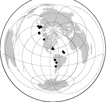
Azimuth Distribution of Events:
Prior Results for this Station
| Study | Thickness | Vp/Vs | Vp | Vs | Poissons Ratio | Extra |
| EARS | 34 km | 1.88 | 6.134 km/s | 3.263 km/s | 0.30 | |
| Crust2.0 | 31 km | 1.80 | 6.134 km/s | 3.406 km/s | 0.28 | C3,continental shelf, 2 km seds. |
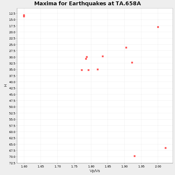
| Global Maxima | 34 km | 1.88 | 6.134 km/s | 3.263 km/s | 0.30 | amp=0.016725287 |
| Local Maxima 1 | 30 km | 1.81 | 6.134 km/s | 3.389 km/s | 0.28 | amp=0.008571747 |
| Local Maxima 2 | 39 km | 1.64 | 6.134 km/s | 3.746 km/s | 0.20 | amp=0.007514412 |
| Local Maxima 3 | 36 km | 1.82 | 6.134 km/s | 3.366 km/s | 0.28 | amp=0.0043079415 |
| Local Maxima 4 | 48 km | 1.64 | 6.134 km/s | 3.734 km/s | 0.21 | amp=0.003949266 |
| Predicted Arrivals for vertical incidence (zero ray parameter) | |
| Ps | 4.88 SECOND |
| PpPs | 15.96 SECOND |
| PsPs/PpSs | 20.84 SECOND |
Events Processed for this Station
Download zip of receiver functions as SAC
Plot maxima for each earthquake.
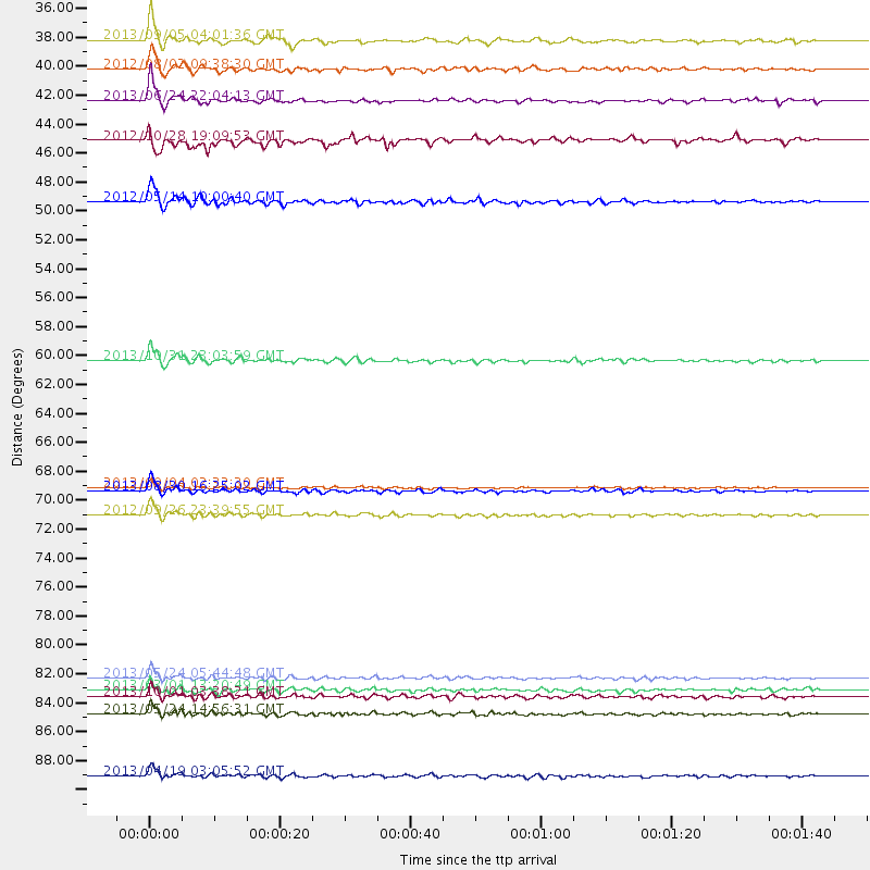
Events Used in the Stack
(14 events)| Radial Match | Distance | Baz | FERegion | Time | Lat/Lon | Depth | Magnitude |
| 97.09387 | 83.9 deg | 331.78 deg | Sea Of Okhotsk | 2013/05/24 05:44:48 GMT | (54.9, 153.2) | 598 km | 8.4 MW, 7.5 MB, 8.3 MW |
| 95.72574 | 69.9 deg | 318.429 deg | Andreanof Islands, Aleutian Is. | 2013/08/30 16:25:02 GMT | (51.5, -175.2) | 29 km | 7.0 MWW, 6.5 ML, 6.8 MI, 6.9 MWC, 6.9 MWB, 7.0 MWW, 7.0 MI, 7.0 MWC |
| 94.29118 | 91.2 deg | 326.799 deg | Kuril Islands | 2013/04/19 03:05:52 GMT | (46.2, 150.8) | 110 km | 7.2 MW, 7.1 MB, 7.2 MW |
| 92.27183 | 86.5 deg | 330.652 deg | Sea Of Okhotsk | 2013/05/24 14:56:31 GMT | (52.2, 151.4) | 624 km | 6.7 MW, 6.7 MB, 6.7 MW |
| 92.0798 | 71.6 deg | 319.277 deg | Andreanof Islands, Aleutian Is. | 2012/09/26 23:39:55 GMT | (51.6, -178.3) | 16 km | 6.3 MB, 6.5 MS, 6.4 MW, 6.4 MW |
| 91.877335 | 60.1 deg | 170.286 deg | Near Coast Of Central Chile | 2013/10/31 23:03:59 GMT | (-30.3, -71.5) | 27 km | 6.6 MWW, 6.4 MWB, 6.5 MWC, 6.6 MWW, 6.6 MI |
| 91.78629 | 48.2 deg | 165.003 deg | Peru-Bolivia Border Region | 2012/05/14 10:00:40 GMT | (-17.7, -69.6) | 106 km | 6.4 MB, 6.2 MW, 6.2 MW |
| 91.22911 | 40.6 deg | 109.224 deg | Northern Mid-Atlantic Ridge | 2013/06/24 22:04:13 GMT | (10.7, -42.6) | 10 km | 6.5 MW, 6.1 MB, 6.3 MS, 6.6 MW |
| 90.80347 | 36.1 deg | 105.226 deg | Northern Mid-Atlantic Ridge | 2013/09/05 04:01:36 GMT | (15.2, -45.2) | 10 km | 6.0 MWW, 5.9 MWB, 6.0 MWW, 6.0 MWC |
| 89.3607 | 69.6 deg | 318.334 deg | Andreanof Islands, Aleutian Is. | 2013/09/04 02:32:30 GMT | (51.6, -174.8) | 20 km | 6.5 MWW, 5.9 ML, 6.3 MWB, 6.5 MI, 6.5 MWC, 6.5 MWW |
| 89.01752 | 85.3 deg | 330.749 deg | Sea Of Okhotsk | 2013/10/01 03:38:21 GMT | (53.2, 152.8) | 573 km | 6.7 MWW, 6.7 MWC, 6.8 MWC, 6.8 MWB |
| 88.14518 | 38.2 deg | 168.763 deg | Peru-Brazil Border Region | 2012/08/02 09:38:30 GMT | (-8.4, -74.3) | 145 km | 5.9 MB, 6.1 MW, 6.1 MW |
| 86.06918 | 84.7 deg | 327.147 deg | Kuril Islands | 2013/03/01 13:20:49 GMT | (51.0, 157.4) | 29 km | 6.3 MB, 6.3 MS, 6.5 MW, 6.4 MW |
| 82.37106 | 43.6 deg | 316.337 deg | Queen Charlotte Islands Region | 2012/10/28 19:09:53 GMT | (52.3, -132.1) | 10 km | 5.6 MB, 5.8 MW, 5.5 MW |
Losers
(21 events)| Radial Match | Distance | Baz | FERegion | Time | Lat/Lon | Depth | Magnitude | Reason |
| 79.129776 | 52.4 deg | 164.581 deg | Chile-Bolivia Border Region | 2012/10/08 01:50:26 GMT | (-21.7, -68.2) | 122 km | 6.0 MB, 5.7 MW, 5.8 MW | |
| 76.503975 | 69.8 deg | 318.061 deg | Andreanof Islands, Aleutian Is. | 2013/08/31 06:38:36 GMT | (51.2, -174.9) | 18 km | 6.0 MWW, 5.5 ML, 5.9 MWB, 5.9 MWC, 6.0 MWC, 6.0 MI, 6.0 MWW | |
| 75.66328 | 86.5 deg | 326.642 deg | Kuril Islands | 2012/07/20 06:10:25 GMT | (49.4, 155.9) | 19 km | 5.7 MB, 5.7 MS, 6.0 MW, 6.1 MW | |
| 75.280556 | 77.9 deg | 344.287 deg | Eastern Siberia, Russia | 2013/02/14 13:13:53 GMT | (67.6, 142.5) | 11 km | 6.5 MB, 6.7 MS, 6.6 MW, 6.7 MW | |
| 75.22595 | 80.1 deg | 328.142 deg | Near East Coast Of Kamchatka | 2013/11/12 07:03:51 GMT | (54.7, 162.3) | 43 km | 6.4 MWW, 6.3 MWC, 6.4 MWW, 6.4 MWB, 6.5 MWC, 6.6 MI | |
| 74.06119 | 69.6 deg | 318.355 deg | Andreanof Islands, Aleutian Is. | 2013/09/04 06:16:49 GMT | (51.6, -174.8) | 21 km | 5.7 MWW, 5.5 ML, 5.5 MI, 5.7 MWB, 5.7 MWW, 5.8 MWC | |
| 70.85404 | 45.5 deg | 170.873 deg | Near Coast Of Peru | 2013/09/25 16:42:43 GMT | (-15.8, -74.5) | 40 km | 7.1 MWW, 6.8 MI, 7.0 MWB, 7.0 MWC, 7.1 MWW, 7.1 MWC | |
| 70.145874 | 39.4 deg | 303.963 deg | Off Coast Of Oregon | 2012/04/11 22:41:46 GMT | (43.6, -127.6) | 8.0 km | 5.8 MB, 5.9 MS, 6.0 MW | |
| 69.59964 | 34.1 deg | 170.806 deg | Northern Peru | 2012/11/28 03:09:48 GMT | (-4.5, -76.1) | 118 km | 5.9 MB, 5.6 MW, 5.7 MW | |
| 64.8923 | 69.6 deg | 318.214 deg | Andreanof Islands, Aleutian Is. | 2013/09/04 04:16:30 GMT | (51.4, -174.7) | 27 km | 5.9 MW, 5.2 ML, 5.4 ML, 5.8 MWW, 5.8 MWW, 5.9 MWC | |
| 64.21815 | 83.6 deg | 325.834 deg | East Of Kuril Islands | 2013/03/24 04:18:33 GMT | (50.7, 160.2) | 8.0 km | 6.1 MB, 5.5 MS, 5.9 MW, 6.1 MW | |
| 63.029343 | 59.6 deg | 161.357 deg | Santiago Del Estero Prov., Arg. | 2013/02/22 12:01:58 GMT | (-27.9, -63.1) | 575 km | 5.8 MB, 6.1 MW, 6.2 MW | |
| 62.788982 | 52.8 deg | 165.233 deg | Northern Chile | 2013/08/23 08:34:06 GMT | (-22.3, -68.6) | 111 km | 5.8 MWW, 5.7 MWD, 5.8 MWW, 5.8 MWB, 5.8 MWC | |
| 62.44273 | 84.8 deg | 327.081 deg | Kuril Islands | 2013/03/01 12:53:51 GMT | (50.9, 157.5) | 33 km | 5.7 MB, 5.8 MS, 6.4 MW, 6.4 MW | |
| 61.870228 | 69.7 deg | 318.371 deg | Andreanof Islands, Aleutian Is. | 2013/09/04 06:27:03 GMT | (51.6, -174.9) | 17 km | 6.0 MWW, 5.5 ML, 5.9 MWB, 6.0 MWW, 6.1 MWC, 6.1 MI | |
| 59.58582 | 55.8 deg | 168.321 deg | Near Coast Of Northern Chile | 2012/05/19 08:35:10 GMT | (-25.7, -70.6) | 28 km | 5.7 MB, 5.5 MS, 5.8 MW, 5.9 MW | |
| 58.414993 | 86.4 deg | 326.503 deg | Kuril Islands | 2012/07/20 06:32:56 GMT | (49.4, 156.1) | 10 km | 5.8 MB, 5.5 MS, 5.8 MW, 5.9 MW | |
| 55.952152 | 84.3 deg | 200.514 deg | Southern East Pacific Rise | 2013/09/25 07:40:23 GMT | (-50.0, -114.0) | 10 km | 5.5 MWC, 5.5 MWC | |
| 54.854004 | 69.5 deg | 318.195 deg | Andreanof Islands, Aleutian Is. | 2013/09/05 05:43:39 GMT | (51.5, -174.6) | 20 km | 5.6 MWW, 5.4 MI, 5.5 MWB, 5.6 MWW, 5.7 MWC, 5.7 ML, 5.8 MWC | |
| 52.890152 | 53.9 deg | 159.58 deg | Salta Province, Argentina | 2012/06/02 07:52:53 GMT | (-22.1, -63.6) | 527 km | 5.8 MB, 5.9 MW, 6.0 MW | |
| 38.85022 | 34.6 deg | 181.172 deg | Near Coast Of Northern Peru | 2013/08/12 09:49:32 GMT | (-5.4, -81.9) | 10 km | 6.2 MWW, 6.1 MWB, 6.2 MWW, 6.2 MWC, 6.3 MWC |
