You are here: Home > Network List > TA - USArray Transportable Network (new EarthScope stations) Stations List
> Station 858A St. Cloud, FL, USA > Earthquake Result Viewer
858A St. Cloud, FL, USA - Earthquake Result Viewer
| Earthquake location: |
Peru-Bolivia Border Region |
| Earthquake latitude/longitude: |
-17.7/-69.6 |
| Earthquake time(UTC): |
2012/05/14 (135) 10:00:40 GMT |
| Earthquake Depth: |
106 km |
| Earthquake Magnitude: |
6.4 MB, 6.2 MW, 6.2 MW |
| Earthquake Catalog/Contributor: |
WHDF/NEIC |
|
| Network: |
TA USArray Transportable Network (new EarthScope stations) |
| Station: |
858A St. Cloud, FL, USA |
| Lat/Lon: |
28.21 N/81.36 W |
| Elevation: |
27 m |
|
| Distance: |
47.0 deg |
| Az: |
345.755 deg |
| Baz: |
164.584 deg |
| Ray Param: |
0.06989961 |
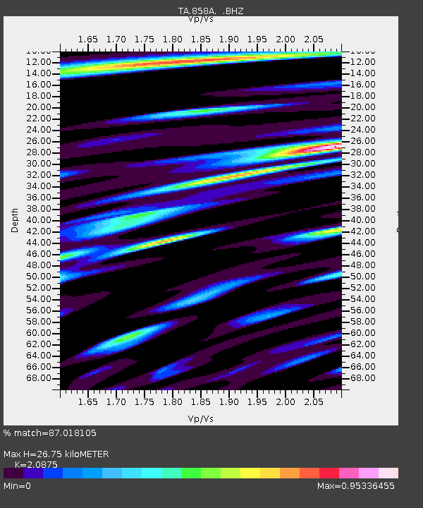
| Estimated Moho Depth: |
26.75 km |
| Estimated Crust Vp/Vs: |
2.09 |
| Assumed Crust Vp: |
6.134 km/s |
| Estimated Crust Vs: |
2.938 km/s |
| Estimated Crust Poisson's Ratio: |
0.35 |
|
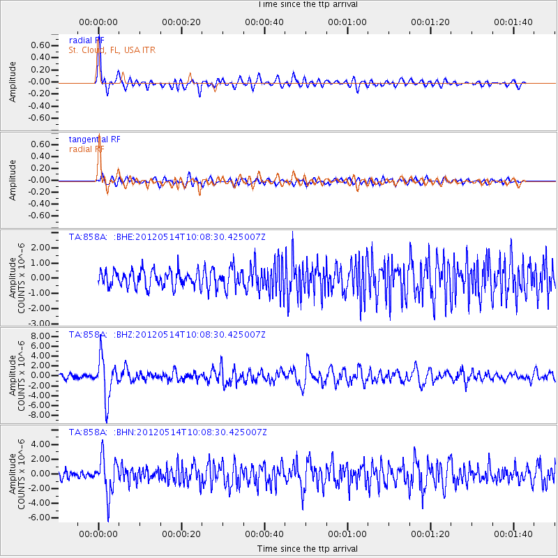
| Radial Match: |
87.018105 % |
| Radial Bump: |
400 |
| Transverse Match: |
63.34225 % |
| Transverse Bump: |
400 |
| SOD ConfigId: |
446234 |
| Insert Time: |
2012-08-08 22:47:32.829 +0000 |
| GWidth: |
2.5 |
| Max Bumps: |
400 |
| Tol: |
0.001 |
|
Signal To Noise
| Channel | StoN | STA | LTA |
| TA:858A: :BHZ:20120514T10:08:30.425007Z | 10.836868 | 4.1538224E-6 | 3.833047E-7 |
| TA:858A: :BHN:20120514T10:08:30.425007Z | 6.3754344 | 2.5294426E-6 | 3.9674828E-7 |
| TA:858A: :BHE:20120514T10:08:30.425007Z | 1.2608932 | 6.5520436E-7 | 5.196351E-7 |
| Arrivals |
| Ps | 5.0 SECOND |
| PpPs | 13 SECOND |
| PsPs/PpSs | 18 SECOND |


