
Station TA 858A - St. Cloud, FL, USA
Network: TA - USArray Transportable Network (new EarthScope stations)
Nearby stations (2 deg radius)
| Station | Name | (Lat, Lon) | Start / End | Elevation |
| 858A | St. Cloud, FL, USA | (28.21, -81.36) | 2012-02-14 / 2599-12-31 | 27 m |
| Crust2 Type: | C3,continental shelf, 2 km seds. |
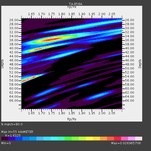
| Thickness Estimate: | 55 km |
| Thickness StdDev: | 9.6 km |
| Vp/Vs Estimate: | 1.63 |
| Vp/Vs StdDev: | 0.11 |
| Vs Estimate: | 3.757 km/s |
| Poisson's Ratio: | 0.20 |
| Peak Value: | 0.03 |
| Assumed Vp: | 6.134 km/s |
| Ps Weight: | 0.33333334 |
| PpPs Weight: | 0.33333334 |
| PsPs Weight: | 0.33333328 |
| Residual Complexity: | 0.914 |
| Nearby stations H: | +- |
| (2.0 deg) Vp/Vs: | +- |
4 with match > 90% ( 15.384615 %) and 8 with match > 80% ( 30.76923 %) out of 26.
Download stack as xyz text file.
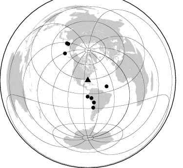
Azimuth Distribution of Events:
Prior Results for this Station
| Study | Thickness | Vp/Vs | Vp | Vs | Poissons Ratio | Extra |
| EARS | 55 km | 1.63 | 6.134 km/s | 3.757 km/s | 0.20 | |
| Crust2.0 | 31 km | 1.80 | 6.134 km/s | 3.406 km/s | 0.28 | C3,continental shelf, 2 km seds. |
| Global Maxima | 55 km | 1.63 | 6.134 km/s | 3.757 km/s | 0.20 | amp=0.026965706 |
| Local Maxima 1 | 35 km | 1.76 | 6.134 km/s | 3.49 km/s | 0.26 | amp=0.023097048 |
| Local Maxima 2 | 40 km | 1.69 | 6.134 km/s | 3.63 km/s | 0.23 | amp=0.016551953 |
| Local Maxima 3 | 43 km | 1.80 | 6.134 km/s | 3.408 km/s | 0.28 | amp=0.010997589 |
| Local Maxima 4 | 27 km | 2.02 | 6.134 km/s | 3.044 km/s | 0.34 | amp=0.010730154 |
| Predicted Arrivals for vertical incidence (zero ray parameter) | |
| Ps | 5.67 SECOND |
| PpPs | 23.60 SECOND |
| PsPs/PpSs | 29.28 SECOND |
Events Processed for this Station
Download zip of receiver functions as SAC
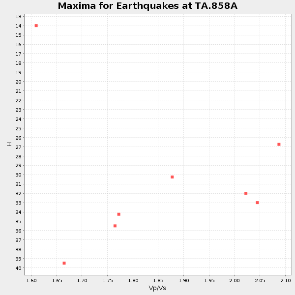
Plot maxima for each earthquake.
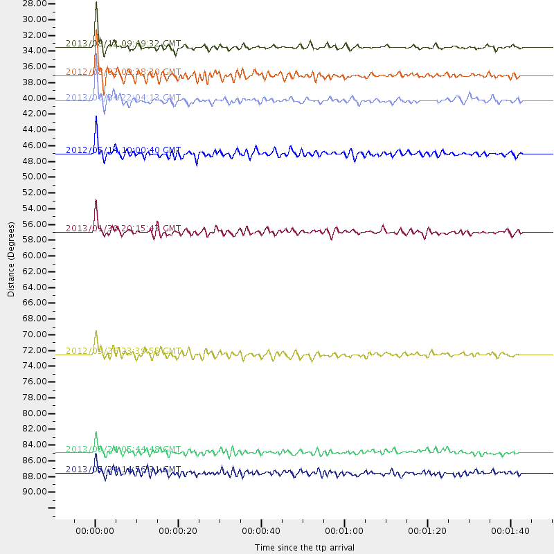
Events Used in the Stack
(8 events)| Radial Match | Distance | Baz | FERegion | Time | Lat/Lon | Depth | Magnitude |
| 94.40344 | 84.9 deg | 331.793 deg | Sea Of Okhotsk | 2013/05/24 05:44:48 GMT | (54.9, 153.2) | 598 km | 8.4 MW, 7.5 MB, 8.3 MW |
| 92.10475 | 87.6 deg | 330.637 deg | Sea Of Okhotsk | 2013/05/24 14:56:31 GMT | (52.2, 151.4) | 624 km | 6.7 MW, 6.7 MB, 6.7 MW |
| 91.6526 | 33.4 deg | 181.022 deg | Near Coast Of Northern Peru | 2013/08/12 09:49:32 GMT | (-5.4, -81.9) | 10 km | 6.2 MWW, 6.1 MWB, 6.2 MWW, 6.2 MWC, 6.3 MWC |
| 90.76628 | 72.5 deg | 319.504 deg | Andreanof Islands, Aleutian Is. | 2012/09/26 23:39:55 GMT | (51.6, -178.3) | 16 km | 6.3 MB, 6.5 MS, 6.4 MW, 6.4 MW |
| 87.23005 | 40.3 deg | 107.799 deg | Northern Mid-Atlantic Ridge | 2013/06/24 22:04:13 GMT | (10.7, -42.6) | 10 km | 6.5 MW, 6.1 MB, 6.3 MS, 6.6 MW |
| 87.018105 | 47.0 deg | 164.584 deg | Peru-Bolivia Border Region | 2012/05/14 10:00:40 GMT | (-17.7, -69.6) | 106 km | 6.4 MB, 6.2 MW, 6.2 MW |
| 85.51543 | 56.9 deg | 168.702 deg | Central Chile | 2013/01/30 20:15:43 GMT | (-28.1, -70.7) | 45 km | 6.5 MB, 6.5 MS, 6.8 MW, 6.8 MW |
| 82.105515 | 37.1 deg | 168.286 deg | Peru-Brazil Border Region | 2012/08/02 09:38:30 GMT | (-8.4, -74.3) | 145 km | 5.9 MB, 6.1 MW, 6.1 MW |
Losers
(18 events)| Radial Match | Distance | Baz | FERegion | Time | Lat/Lon | Depth | Magnitude | Reason |
| 79.738014 | 92.1 deg | 326.728 deg | Kuril Islands | 2013/04/19 03:05:52 GMT | (46.2, 150.8) | 110 km | 7.2 MW, 7.1 MB, 7.2 MW | |
| 72.582085 | 44.4 deg | 317.21 deg | Queen Charlotte Islands Region | 2012/10/28 19:09:53 GMT | (52.3, -132.1) | 10 km | 5.6 MB, 5.8 MW, 5.5 MW | |
| 70.38708 | 40.0 deg | 305.172 deg | Off Coast Of Oregon | 2012/04/11 22:41:46 GMT | (43.6, -127.6) | 8.0 km | 5.8 MB, 5.9 MS, 6.0 MW | |
| 68.858025 | 32.9 deg | 170.322 deg | Northern Peru | 2012/11/28 03:09:48 GMT | (-4.5, -76.1) | 118 km | 5.9 MB, 5.6 MW, 5.7 MW | |
| 68.29771 | 54.6 deg | 168.038 deg | Near Coast Of Northern Chile | 2012/05/19 08:35:10 GMT | (-25.7, -70.6) | 28 km | 5.7 MB, 5.5 MS, 5.8 MW, 5.9 MW | |
| 66.79014 | 44.3 deg | 168.896 deg | Southern Peru | 2013/05/14 23:39:15 GMT | (-15.7, -73.3) | 105 km | 5.5 MW, 5.5 MW, 5.7 MB | |
| 65.88528 | 44.6 deg | 166.742 deg | Southern Peru | 2013/07/17 02:37:43 GMT | (-15.7, -71.7) | 7.0 km | 6.0 MW, 5.6 MB, 5.8 MS, 5.8 MW | |
| 63.118725 | 58.5 deg | 161.022 deg | Santiago Del Estero Prov., Arg. | 2013/02/22 12:01:58 GMT | (-27.9, -63.1) | 575 km | 5.8 MB, 6.1 MW, 6.2 MW | |
| 60.974106 | 33.8 deg | 100.935 deg | Northern Mid-Atlantic Ridge | 2012/10/04 23:14:56 GMT | (17.4, -46.5) | 10 km | 5.5 MW, 5.0 MS, 5.4 MW, 5.3 MB | |
| 58.918926 | 77.2 deg | 323.996 deg | Near Islands, Aleutian Islands | 2012/06/19 15:56:32 GMT | (53.4, 171.6) | 14 km | 6.2 MB, 5.7 MS, 6.0 MW, 6.1 MW | |
| 58.424065 | 70.8 deg | 102.23 deg | North Of Ascension Island | 2012/04/10 05:09:08 GMT | (-1.3, -14.0) | 10 km | 5.8 MW, 5.4 MS, 5.4 MB, 5.8 MW | |
| 56.55518 | 51.7 deg | 164.875 deg | Northern Chile | 2013/08/23 08:34:06 GMT | (-22.3, -68.6) | 111 km | 5.8 MWW, 5.7 MWD, 5.8 MWW, 5.8 MWB, 5.8 MWC | |
| 54.120438 | 84.5 deg | 325.863 deg | East Of Kuril Islands | 2013/03/24 04:18:33 GMT | (50.7, 160.2) | 8.0 km | 6.1 MB, 5.5 MS, 5.9 MW, 6.1 MW | |
| 51.990368 | 65.8 deg | 317.048 deg | Fox Islands, Aleutian Islands | 2013/07/03 03:40:27 GMT | (51.6, -167.0) | 5.1 km | 5.8 MW, 5.7 MW, 5.9 MB | |
| 51.624756 | 58.7 deg | 161.333 deg | Santiago Del Estero Prov., Arg. | 2012/03/05 07:46:10 GMT | (-28.2, -63.3) | 554 km | 6.0 MB, 6.1 MW, 6.1 MW | |
| 51.616898 | 72.4 deg | 319.558 deg | Andreanof Islands, Aleutian Is. | 2013/04/21 13:48:29 GMT | (51.7, -178.2) | 44 km | 5.6 MW, 5.7 MW, 5.9 MB | |
| 50.671654 | 52.9 deg | 159.151 deg | Salta Province, Argentina | 2012/06/02 07:52:53 GMT | (-22.1, -63.6) | 527 km | 5.8 MB, 5.9 MW, 6.0 MW | |
| 48.381687 | 87.1 deg | 326.558 deg | Kuril Islands | 2012/10/16 12:41:25 GMT | (49.6, 156.4) | 81 km | 6.2 MB, 5.6 MW, 5.6 MW |
