You are here: Home > Network List > TA - USArray Transportable Network (new EarthScope stations) Stations List
> Station TASL Snake Pit, Albuquerque Seismic Lab, NM, USA > Earthquake Result Viewer
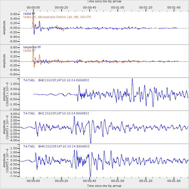
TASL Snake Pit, Albuquerque Seismic Lab, NM, USA - Earthquake Result Viewer

| Earthquake location: |
Peru-Bolivia Border Region |
| Earthquake latitude/longitude: |
-17.7/-69.6 |
| Earthquake time(UTC): |
2012/05/14 (135) 10:00:40 GMT |
| Earthquake Depth: |
106 km |
| Earthquake Magnitude: |
6.4 MB, 6.2 MW, 6.2 MW |
| Earthquake Catalog/Contributor: |
WHDF/NEIC |
|
| Network: |
TA USArray Transportable Network (new EarthScope stations) |
| Station: |
TASL Snake Pit, Albuquerque Seismic Lab, NM, USA |
| Lat/Lon: |
34.95 N/106.46 W |
| Elevation: |
1838 m |
|
| Distance: |
63.0 deg |
| Az: |
326.407 deg |
| Baz: |
140.051 deg |
| Ray Param: |
0.059591245 |
| Estimated Moho Depth: |
10.25 km |
| Estimated Crust Vp/Vs: |
1.85 |
| Assumed Crust Vp: |
6.502 km/s |
| Estimated Crust Vs: |
3.514 km/s |
| Estimated Crust Poisson's Ratio: |
0.29 |
|
| Radial Match: |
96.037094 % |
| Radial Bump: |
365 |
| Transverse Match: |
82.0068 % |
| Transverse Bump: |
400 |
| SOD ConfigId: |
446234 |
| Insert Time: |
2012-08-08 22:52:44.966 +0000 |
| GWidth: |
2.5 |
| Max Bumps: |
400 |
| Tol: |
0.001 |
|
Signal To Noise
| Channel | StoN | STA | LTA |
| TA:TASL: :BHZ:20120514T10:10:24.899983Z | 8.028176 | 1.0100933E-6 | 1.2581853E-7 |
| TA:TASL: :BHN:20120514T10:10:24.899983Z | 8.316885 | 4.2782506E-7 | 5.144054E-8 |
| TA:TASL: :BHE:20120514T10:10:24.899983Z | 5.8101273 | 3.1647335E-7 | 5.446926E-8 |
| Arrivals |
| Ps | 1.4 SECOND |
| PpPs | 4.3 SECOND |
| PsPs/PpSs | 5.7 SECOND |


