
Station TA TASL - Snake Pit, Albuquerque Seismic Lab, NM, USA
Network: TA - USArray Transportable Network (new EarthScope stations)
Nearby stations (2 deg radius)
| Station | Name | (Lat, Lon) | Start / End | Elevation |
| TASL | Snake Pit, Albuquerque Seismic Lab, NM, USA | (34.95, -106.46) | 2012-04-24 / 2599-12-31 | 1838 m |
| Crust2 Type: | X2,Rift, Rio Grande, Baikal, 0.5km sediments |
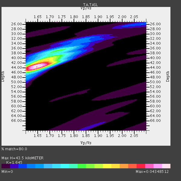
| Thickness Estimate: | 44 km |
| Thickness StdDev: | 1.1 km |
| Vp/Vs Estimate: | 1.64 |
| Vp/Vs StdDev: | 0.02 |
| Vs Estimate: | 3.952 km/s |
| Poisson's Ratio: | 0.21 |
| Peak Value: | 0.04 |
| Assumed Vp: | 6.502 km/s |
| Ps Weight: | 0.33333334 |
| PpPs Weight: | 0.33333334 |
| PsPs Weight: | 0.33333328 |
| Residual Complexity: | 0.561 |
| Nearby stations H: | 43 km +- 1.0 km |
| (2.0 deg) Vp/Vs: | 1.64 +- 0.01 |
10 with match > 90% ( 34.482758 %) and 17 with match > 80% ( 58.62069 %) out of 29.
Download stack as xyz text file.
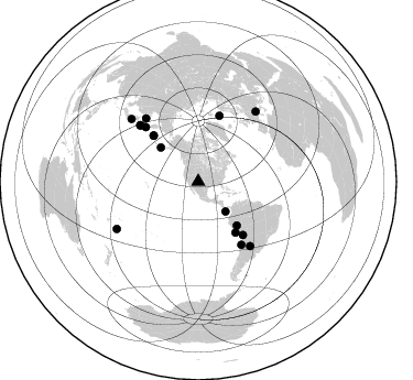
Azimuth Distribution of Events:
Prior Results for this Station
| Study | Thickness | Vp/Vs | Vp | Vs | Poissons Ratio | Extra |
| EARS | 44 km | 1.64 | 6.502 km/s | 3.952 km/s | 0.21 | |
| Crust2.0 | 33 km | 1.77 | 6.502 km/s | 3.68 km/s | 0.26 | X2,Rift, Rio Grande, Baikal, 0.5km sediments |
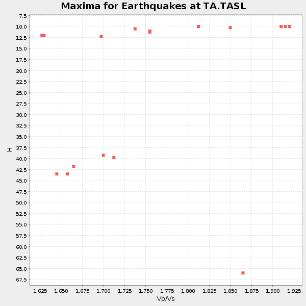
| Global Maxima | 44 km | 1.64 | 6.502 km/s | 3.952 km/s | 0.21 | amp=0.04348512 |
| Local Maxima 1 | 42 km | 1.66 | 6.502 km/s | 3.905 km/s | 0.22 | amp=0.025746685 |
| Local Maxima 2 | 40 km | 1.71 | 6.502 km/s | 3.808 km/s | 0.24 | amp=0.017018214 |
| Local Maxima 3 | 37 km | 1.72 | 6.502 km/s | 3.785 km/s | 0.24 | amp=0.014013249 |
| Local Maxima 4 | 32 km | 1.83 | 6.502 km/s | 3.558 km/s | 0.29 | amp=0.0056355055 |
| Predicted Arrivals for vertical incidence (zero ray parameter) | |
| Ps | 4.32 SECOND |
| PpPs | 17.70 SECOND |
| PsPs/PpSs | 22.01 SECOND |
Events Processed for this Station
Download zip of receiver functions as SAC
Plot maxima for each earthquake.
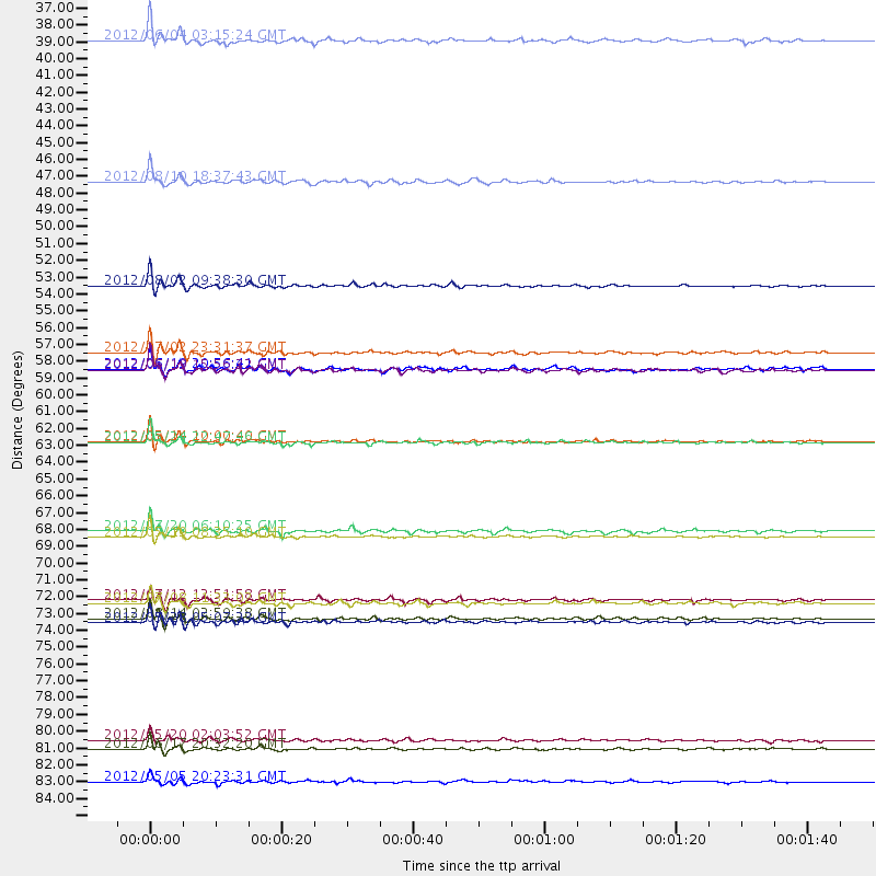
Events Used in the Stack
(17 events)| Radial Match | Distance | Baz | FERegion | Time | Lat/Lon | Depth | Magnitude |
| 97.12727 | 74.6 deg | 320.397 deg | Sea Of Okhotsk | 2012/08/14 02:59:38 GMT | (49.8, 145.1) | 583 km | 6.9 MB, 7.7 MW, 7.7 MW |
| 96.545616 | 46.0 deg | 312.165 deg | Fox Islands, Aleutian Islands | 2012/08/10 18:37:43 GMT | (52.6, -167.4) | 13 km | 5.9 MB, 6.2 MS, 6.2 MW, 6.2 MW |
| 96.037094 | 63.0 deg | 140.051 deg | Peru-Bolivia Border Region | 2012/05/14 10:00:40 GMT | (-17.7, -69.6) | 106 km | 6.4 MB, 6.2 MW, 6.2 MW |
| 94.918755 | 63.0 deg | 17.845 deg | Norwegian Sea | 2012/05/24 22:47:46 GMT | (73.0, 5.7) | 10 km | 5.7 MB, 6.1 MS, 6.1 MW, 6.2 MW |
| 94.88965 | 52.8 deg | 138.545 deg | Peru-Brazil Border Region | 2012/08/02 09:38:30 GMT | (-8.4, -74.3) | 145 km | 5.9 MB, 6.1 MW, 6.1 MW |
| 94.15502 | 58.3 deg | 315.759 deg | Near Islands, Aleutian Islands | 2012/06/19 15:56:32 GMT | (53.4, 171.6) | 14 km | 6.2 MB, 5.7 MS, 6.0 MW, 6.1 MW |
| 93.889534 | 83.1 deg | 313.114 deg | Near East Coast Of Honshu, Japan | 2012/06/17 20:32:20 GMT | (38.9, 141.8) | 36 km | 6.0 MB, 5.9 MS, 6.3 MW, 6.4 MW |
| 93.24915 | 69.3 deg | 145.565 deg | Near Coast Of Northern Chile | 2012/05/19 08:35:10 GMT | (-25.7, -70.6) | 28 km | 5.7 MB, 5.5 MS, 5.8 MW, 5.9 MW |
| 93.00774 | 57.2 deg | 143.743 deg | Near Coast Of Peru | 2012/07/02 23:31:37 GMT | (-14.4, -75.6) | 40 km | 6.0 MB, 5.2 MS, 5.7 MW, 5.6 MW |
| 92.80027 | 36.7 deg | 137.541 deg | South Of Panama | 2012/06/04 03:15:24 GMT | (5.5, -82.6) | 7.0 km | 5.8 MB, 5.8 MS, 6.3 MW, 6.1 MW |
| 89.86554 | 74.9 deg | 141.044 deg | Santiago Del Estero Prov., Arg. | 2012/05/28 05:07:23 GMT | (-28.0, -63.1) | 587 km | 6.0 MB, 6.7 MW, 6.8 MW |
| 87.13594 | 68.9 deg | 316.048 deg | Kuril Islands | 2012/07/20 06:10:25 GMT | (49.4, 155.9) | 19 km | 5.7 MB, 5.7 MS, 6.0 MW, 6.1 MW |
| 86.093575 | 58.2 deg | 315.742 deg | Near Islands, Aleutian Islands | 2012/06/19 20:56:41 GMT | (53.4, 171.7) | 12 km | 5.9 MB, 5.2 MS, 5.6 MW, 5.7 MW |
| 85.21618 | 73.6 deg | 314.231 deg | Kuril Islands | 2012/07/08 11:33:02 GMT | (45.5, 151.3) | 20 km | 5.7 MB, 5.6 MS, 6.0 MW, 5.8 MW |
| 84.84721 | 73.4 deg | 314.04 deg | Kuril Islands | 2012/07/12 12:51:58 GMT | (45.5, 151.7) | 12 km | 5.5 MB, 5.6 MS, 5.8 MW, 5.7 MW |
| 83.51012 | 85.3 deg | 239.892 deg | Tonga Islands | 2012/05/05 20:23:31 GMT | (-21.5, -174.2) | 8.5 km | 5.6 MS, 5.7 MW, 5.6 MW |
| 80.741196 | 82.5 deg | 39.406 deg | Northern Italy | 2012/05/20 02:03:52 GMT | (44.9, 11.2) | 6.3 km | 5.8 MB, 6.0 MS, 6.0 MW, 6.1 MW |
Losers
(12 events)| Radial Match | Distance | Baz | FERegion | Time | Lat/Lon | Depth | Magnitude | Reason |
| 78.815704 | 95.2 deg | 255.871 deg | Vanuatu Islands | 2012/07/06 02:28:22 GMT | (-14.7, 167.3) | 160 km | 5.7 MB, 6.3 MW, 6.3 MW | |
| 75.88848 | 69.8 deg | 137.709 deg | Salta Province, Argentina | 2012/06/02 07:52:53 GMT | (-22.1, -63.6) | 527 km | 5.8 MB, 5.9 MW, 6.0 MW | |
| 68.49841 | 88.1 deg | 242.594 deg | Fiji Islands Region | 2012/08/05 13:55:10 GMT | (-21.1, -178.4) | 484 km | 5.5 MB, 5.8 MW, 5.9 MW | |
| 67.465996 | 88.0 deg | 242.898 deg | Fiji Islands Region | 2012/07/18 08:09:46 GMT | (-20.9, -178.5) | 537 km | 5.5 MB, 5.9 MW, 6.0 MW | |
| 63.30484 | 85.6 deg | 242.105 deg | Tonga Islands | 2012/05/28 21:47:09 GMT | (-20.0, -176.0) | 211 km | 5.9 MW, 5.3 MB, 5.9 MW | |
| 60.49784 | 90.0 deg | 34.746 deg | Bulgaria | 2012/05/22 00:00:32 GMT | (42.6, 23.0) | 10 km | 5.7 MB, 5.3 MS, 5.6 MW, 5.5 MW | |
| 59.342697 | 89.6 deg | 242.553 deg | South Of Fiji Islands | 2012/05/29 03:33:25 GMT | (-22.1, -179.6) | 602 km | 5.6 MB, 5.8 MW, 5.9 MW | |
| 56.63821 | 79.2 deg | 320.974 deg | Primor'ye, Russia | 2012/07/29 09:20:54 GMT | (47.4, 139.1) | 502 km | 5.6 MB, 5.6 MW, 5.7 MW | |
| 51.74399 | 42.3 deg | 315.503 deg | Alaska Peninsula | 2012/08/08 14:05:17 GMT | (54.9, -161.2) | 43 km | 5.6 MB, 5.2 MW, 5.1 MW | |
| 51.111217 | 83.5 deg | 312.741 deg | Near East Coast Of Honshu, Japan | 2012/08/29 19:05:11 GMT | (38.4, 141.8) | 47 km | 5.8 MB, 5.1 MS, 5.5 MW, 5.5 MW | |
| 45.8847 | 68.8 deg | 315.921 deg | Kuril Islands | 2012/07/20 06:32:56 GMT | (49.4, 156.1) | 10 km | 5.8 MB, 5.5 MS, 5.8 MW, 5.9 MW | |
| 45.519554 | 92.0 deg | 304.968 deg | Bonin Islands, Japan Region | 2012/05/26 21:48:10 GMT | (26.9, 140.1) | 487 km | 5.5 MB, 6.0 MW, 6.0 MW |
