You are here: Home > Network List > PS - Pacific21 Stations List
> Station BAG 7aguio, Philippines > Earthquake Result Viewer
BAG 7aguio, Philippines - Earthquake Result Viewer
| Earthquake location: |
Off East Coast Of Honshu, Japan |
| Earthquake latitude/longitude: |
39.5/143.2 |
| Earthquake time(UTC): |
2012/05/20 (141) 07:19:54 GMT |
| Earthquake Depth: |
11 km |
| Earthquake Magnitude: |
5.6 MB |
| Earthquake Catalog/Contributor: |
WHDF/NEIC |
|
| Network: |
PS Pacific21 |
| Station: |
BAG 7aguio, Philippines |
| Lat/Lon: |
16.41 N/120.58 E |
| Elevation: |
1507 m |
|
| Distance: |
30.4 deg |
| Az: |
227.031 deg |
| Baz: |
36.12 deg |
| Ray Param: |
0.07935002 |
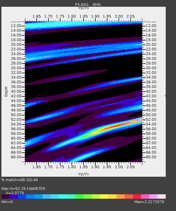
| Estimated Moho Depth: |
52.25 km |
| Estimated Crust Vp/Vs: |
2.08 |
| Assumed Crust Vp: |
6.468 km/s |
| Estimated Crust Vs: |
3.113 km/s |
| Estimated Crust Poisson's Ratio: |
0.35 |
|
| Radial Match: |
89.30146 % |
| Radial Bump: |
400 |
| Transverse Match: |
83.107704 % |
| Transverse Bump: |
400 |
| SOD ConfigId: |
446234 |
| Insert Time: |
2012-08-25 18:23:17.580 +0000 |
| GWidth: |
2.5 |
| Max Bumps: |
400 |
| Tol: |
0.001 |
|
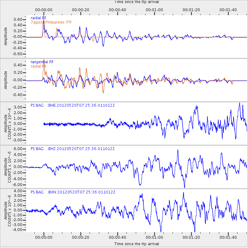
Signal To Noise
| Channel | StoN | STA | LTA |
| PS:BAG: :BHZ:20120520T07:25:36.011012Z | 8.156282 | 7.0227213E-7 | 8.6101984E-8 |
| PS:BAG: :BHN:20120520T07:25:36.011012Z | 3.386259 | 3.9406498E-7 | 1.1637178E-7 |
| PS:BAG: :BHE:20120520T07:25:36.011012Z | 2.3309941 | 2.6682727E-7 | 1.144693E-7 |
| Arrivals |
| Ps | 9.3 SECOND |
| PpPs | 23 SECOND |
| PsPs/PpSs | 33 SECOND |


