You are here: Home > Network List > AK - Alaska Regional Network Stations List
> Station GLM Gilmore Dome, AK, USA > Earthquake Result Viewer
GLM Gilmore Dome, AK, USA - Earthquake Result Viewer
| Earthquake location: |
Norwegian Sea |
| Earthquake latitude/longitude: |
73.0/5.7 |
| Earthquake time(UTC): |
2012/05/24 (145) 22:47:46 GMT |
| Earthquake Depth: |
10 km |
| Earthquake Magnitude: |
5.7 MB, 6.1 MS, 6.1 MW, 6.2 MW |
| Earthquake Catalog/Contributor: |
WHDF/NEIC |
|
| Network: |
AK Alaska Regional Network |
| Station: |
GLM Gilmore Dome, AK, USA |
| Lat/Lon: |
64.99 N/147.40 W |
| Elevation: |
701 m |
|
| Distance: |
41.1 deg |
| Az: |
342.989 deg |
| Baz: |
11.706 deg |
| Ray Param: |
0.07397966 |
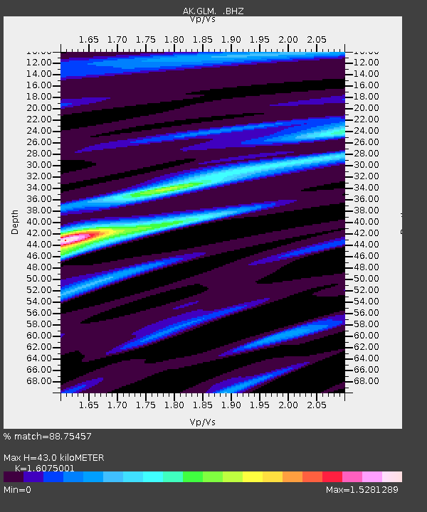
| Estimated Moho Depth: |
43.0 km |
| Estimated Crust Vp/Vs: |
1.61 |
| Assumed Crust Vp: |
6.566 km/s |
| Estimated Crust Vs: |
4.085 km/s |
| Estimated Crust Poisson's Ratio: |
0.18 |
|
| Radial Match: |
88.75457 % |
| Radial Bump: |
240 |
| Transverse Match: |
54.93538 % |
| Transverse Bump: |
400 |
| SOD ConfigId: |
446234 |
| Insert Time: |
2012-08-25 21:02:16.550 +0000 |
| GWidth: |
2.5 |
| Max Bumps: |
400 |
| Tol: |
0.001 |
|

Signal To Noise
| Channel | StoN | STA | LTA |
| AK:GLM: :BHZ:20120524T22:55:00.168011Z | 7.5600543 | 5.3501543E-7 | 7.076873E-8 |
| AK:GLM: :BHN:20120524T22:55:00.168011Z | 2.7245953 | 2.515295E-7 | 9.231812E-8 |
| AK:GLM: :BHE:20120524T22:55:00.168011Z | 1.3481951 | 1.2740871E-7 | 9.450317E-8 |
| Arrivals |
| Ps | 4.3 SECOND |
| PpPs | 16 SECOND |
| PsPs/PpSs | 20 SECOND |


