
Station AK GLM - Gilmore Dome, AK, USA
Network: AK - Alaska Regional Network
Nearby stations (2 deg radius)
| Station | Name | (Lat, Lon) | Start / End | Elevation |
| GLM | Gilmore Dome, AK, USA | (64.99, -147.40) | 2011-10-19 / 2599-12-31 | 701 m |
| Crust2 Type: | L8,thin continental arc, Cordilleras, 0.5 km seds. |
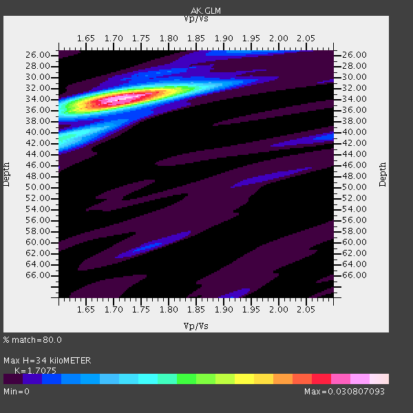
| Thickness Estimate: | 34 km |
| Thickness StdDev: | 1.0 km |
| Vp/Vs Estimate: | 1.71 |
| Vp/Vs StdDev: | 0.02 |
| Vs Estimate: | 3.845 km/s |
| Poisson's Ratio: | 0.24 |
| Peak Value: | 0.03 |
| Assumed Vp: | 6.566 km/s |
| Ps Weight: | 0.33333334 |
| PpPs Weight: | 0.33333334 |
| PsPs Weight: | 0.33333328 |
| Residual Complexity: | 0.360 |
| Nearby stations H: | +- |
| (2.0 deg) Vp/Vs: | +- |
5 with match > 90% ( 17.857143 %) and 13 with match > 80% ( 46.42857 %) out of 28.
Download stack as xyz text file.
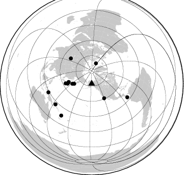
Azimuth Distribution of Events:
Prior Results for this Station
| Study | Thickness | Vp/Vs | Vp | Vs | Poissons Ratio | Extra |
| EARS | 34 km | 1.71 | 6.566 km/s | 3.845 km/s | 0.24 | |
| Crust2.0 | 34 km | 1.77 | 6.566 km/s | 3.707 km/s | 0.27 | L8,thin continental arc, Cordilleras, 0.5 km seds. |
| Global Maxima | 34 km | 1.71 | 6.566 km/s | 3.845 km/s | 0.24 | amp=0.030807093 |
| Local Maxima 1 | 33 km | 1.70 | 6.566 km/s | 3.857 km/s | 0.24 | amp=0.013161436 |
| Local Maxima 2 | 42 km | 1.61 | 6.566 km/s | 4.091 km/s | 0.18 | amp=0.011352204 |
| Local Maxima 3 | 35 km | 1.71 | 6.566 km/s | 3.845 km/s | 0.24 | amp=0.005999981 |
| Local Maxima 4 | 40 km | 2.10 | 6.566 km/s | 3.13 km/s | 0.35 | amp=0.004506041 |
| Predicted Arrivals for vertical incidence (zero ray parameter) | |
| Ps | 3.66 SECOND |
| PpPs | 14.02 SECOND |
| PsPs/PpSs | 17.68 SECOND |
Events Processed for this Station
Download zip of receiver functions as SAC
Plot maxima for each earthquake.
Events Used in the Stack
(13 events)| Radial Match | Distance | Baz | FERegion | Time | Lat/Lon | Depth | Magnitude |
| 96.28361 | 45.4 deg | 274.222 deg | Hokkaido, Japan Region | 2012/05/23 15:02:25 GMT | (41.3, 142.1) | 46 km | 6.2 MB, 5.5 MS, 5.9 MW, 6.0 MW |
| 95.87966 | 47.5 deg | 269.946 deg | Off East Coast Of Honshu, Japan | 2012/12/07 08:18:23 GMT | (37.9, 143.9) | 31 km | 7.2 MB, 7.3 MS, 7.3 MW, 7.3 MW |
| 92.75324 | 86.4 deg | 223.536 deg | Vanuatu Islands | 2012/07/06 02:28:22 GMT | (-14.7, 167.3) | 160 km | 5.7 MB, 6.3 MW, 6.3 MW |
| 91.331 | 46.2 deg | 272.139 deg | Off East Coast Of Honshu, Japan | 2012/10/01 22:21:46 GMT | (39.8, 143.1) | 15 km | 5.6 MB, 5.7 MS, 6.1 MW, 6.0 MW |
| 90.74659 | 64.5 deg | 320.458 deg | Northern Xinjiang, China | 2012/06/29 21:07:33 GMT | (43.4, 84.7) | 18 km | 6.2 MB, 6.4 MS, 6.3 MW, 6.3 MW |
| 89.692604 | 81.8 deg | 240.118 deg | New Ireland Region, P.N.G. | 2012/07/28 20:03:56 GMT | (-4.7, 153.2) | 41 km | 6.1 MB, 6.3 MS, 6.5 MW, 6.5 MW |
| 88.75457 | 41.1 deg | 11.706 deg | Norwegian Sea | 2012/05/24 22:47:46 GMT | (73.0, 5.7) | 10 km | 5.7 MB, 6.1 MS, 6.1 MW, 6.2 MW |
| 88.0751 | 38.0 deg | 139.574 deg | Off W. Coast Of Baja California | 2012/12/14 10:36:01 GMT | (31.1, -119.7) | 13 km | 6.2 MB, 6.1 MS, 6.3 MW, 6.4 MW |
| 87.52598 | 51.2 deg | 270.447 deg | Off East Coast Of Honshu, Japan | 2012/06/05 19:31:33 GMT | (34.9, 141.1) | 15 km | 6.2 MB, 6.0 MS, 6.1 MW, 6.1 MW |
| 86.98263 | 38.1 deg | 269.686 deg | Kuril Islands | 2012/07/08 11:33:02 GMT | (45.5, 151.3) | 20 km | 5.7 MB, 5.6 MS, 6.0 MW, 5.8 MW |
| 86.22511 | 74.7 deg | 110.963 deg | South Of Panama | 2012/06/04 00:45:15 GMT | (5.3, -82.6) | 7.0 km | 5.9 MB, 5.9 MS, 6.3 MW, 6.2 MW |
| 85.187355 | 34.4 deg | 269.601 deg | Kuril Islands | 2012/04/23 22:40:22 GMT | (48.4, 154.7) | 31 km | 5.6 MW, 5.2 MS, 5.4 MB, 5.7 MW |
| 80.90568 | 86.5 deg | 258.733 deg | Irian Jaya Region, Indonesia | 2012/04/21 01:16:52 GMT | (-1.6, 134.3) | 16 km | 6.3 MB, 6.6 MS, 6.7 MW, 6.6 MW |
Losers
(15 events)| Radial Match | Distance | Baz | FERegion | Time | Lat/Lon | Depth | Magnitude | Reason |
| 79.29643 | 62.4 deg | 117.14 deg | Near Coast Of Chiapas, Mexico | 2012/05/01 22:43:33 GMT | (14.4, -92.9) | 14 km | 5.6 MB, 5.8 MS, 6.0 MW, 5.9 MW | |
| 77.14429 | 65.9 deg | 279.553 deg | Northeast Of Taiwan | 2012/08/08 07:11:01 GMT | (25.9, 124.9) | 133 km | 5.5 MB, 5.4 MW, 5.4 MW | |
| 72.38396 | 49.4 deg | 271.819 deg | Near East Coast Of Honshu, Japan | 2012/04/13 10:10:01 GMT | (37.0, 141.2) | 11 km | 5.6 MB, 5.4 MS, 5.7 MW, 5.7 MW | |
| 72.11603 | 41.8 deg | 281.91 deg | Primor'ye, Russia | 2012/07/29 09:20:54 GMT | (47.4, 139.1) | 502 km | 5.6 MB, 5.6 MW, 5.7 MW | |
| 71.934814 | 69.2 deg | 16.087 deg | Northern Italy | 2012/05/20 02:03:52 GMT | (44.9, 11.2) | 6.3 km | 5.8 MB, 6.0 MS, 6.0 MW, 6.1 MW | |
| 69.66644 | 47.7 deg | 270.181 deg | Off East Coast Of Honshu, Japan | 2012/11/05 04:30:26 GMT | (37.8, 143.6) | 19 km | 5.7 MB, 5.2 MS, 5.6 MW, 5.6 MW | |
| 67.05747 | 69.3 deg | 111.515 deg | Costa Rica | 2012/10/24 00:45:32 GMT | (10.1, -85.3) | 17 km | 6.0 MB, 6.2 MS, 6.5 MW, 6.4 MW | |
| 65.51523 | 88.6 deg | 222.561 deg | Vanuatu Islands | 2012/12/02 00:54:22 GMT | (-17.0, 167.6) | 32 km | 6.1 MB, 6.0 MS, 6.1 MW, 6.2 MW | |
| 64.090576 | 84.0 deg | 228.463 deg | Solomon Islands | 2012/07/03 03:49:33 GMT | (-10.8, 163.3) | 92 km | 5.6 MB, 5.5 MW, 5.5 MW | |
| 61.9333 | 88.4 deg | 204.974 deg | Tonga Islands | 2012/09/24 10:31:23 GMT | (-21.2, -174.3) | 10 km | 5.7 MB, 5.4 MS, 5.5 MW, 5.5 MW | |
| 55.156857 | 81.8 deg | 240.272 deg | New Ireland Region, P.N.G. | 2012/12/15 19:30:02 GMT | (-4.6, 153.0) | 52 km | 5.9 MB, 6.1 MW, 6.1 MW | |
| 54.719624 | 80.2 deg | 270.707 deg | Mindanao, Philippines | 2012/11/02 18:17:32 GMT | (9.2, 126.2) | 37 km | 6.2 MB, 5.7 MS, 6.1 MW, 6.1 MW | |
| 51.347115 | 34.6 deg | 269.783 deg | Kuril Islands | 2012/10/14 09:41:58 GMT | (48.3, 154.4) | 35 km | 5.7 MB, 5.2 MS, 5.7 MW, 5.7 MW | |
| 48.94706 | 65.8 deg | 113.759 deg | Off Coast Of Central America | 2012/08/28 06:08:16 GMT | (12.5, -88.7) | 35 km | 5.5 MW, 5.0 MS, 5.1 MB, 5.5 MW | |
| 21.435804 | 60.6 deg | 276.881 deg | Ryukyu Islands, Japan | 2012/07/09 19:25:07 GMT | (29.4, 130.1) | 39 km | 5.6 MW, 5.1 MS, 5.1 MB, 5.5 MW |
