You are here: Home > Network List > IC - New China Digital Seismograph Network Stations List
> Station HIA Hailar, Neimenggu Province, China > Earthquake Result Viewer
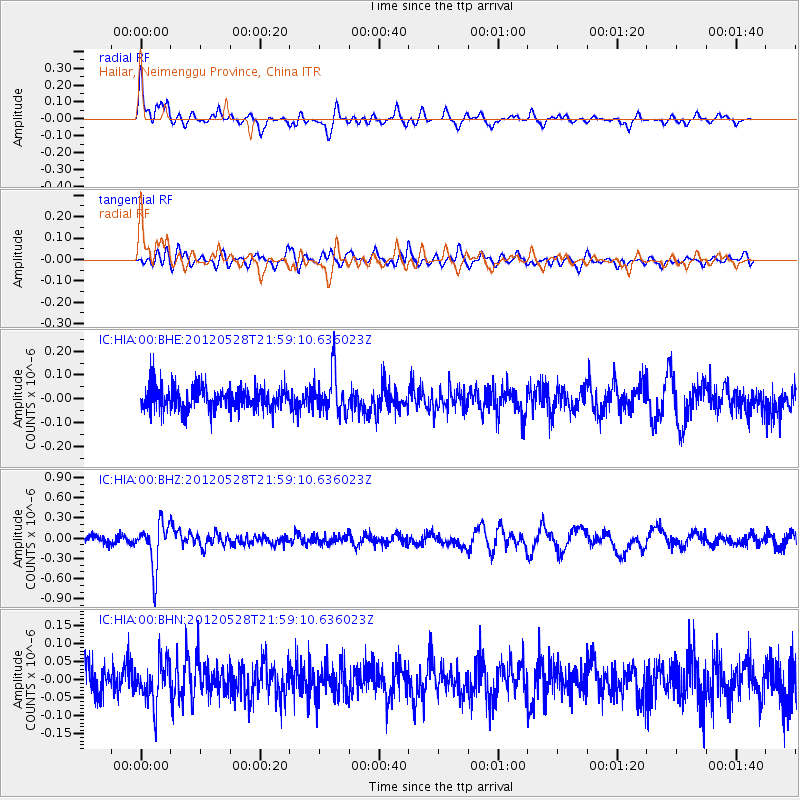
HIA Hailar, Neimenggu Province, China - Earthquake Result Viewer
*The percent match for this event was below the threshold and hence no stack was calculated.
| Earthquake location: |
Tonga Islands |
| Earthquake latitude/longitude: |
-20.0/-176.0 |
| Earthquake time(UTC): |
2012/05/28 (149) 21:47:09 GMT |
| Earthquake Depth: |
211 km |
| Earthquake Magnitude: |
5.9 MW, 5.3 MB, 5.9 MW |
| Earthquake Catalog/Contributor: |
WHDF/NEIC |
|
| Network: |
IC New China Digital Seismograph Network |
| Station: |
HIA Hailar, Neimenggu Province, China |
| Lat/Lon: |
49.27 N/119.74 E |
| Elevation: |
620 m |
|
| Distance: |
89.4 deg |
| Az: |
323.832 deg |
| Baz: |
122.056 deg |
| Ray Param: |
$rayparam |
*The percent match for this event was below the threshold and hence was not used in the summary stack. |
|
| Radial Match: |
75.98201 % |
| Radial Bump: |
383 |
| Transverse Match: |
57.510773 % |
| Transverse Bump: |
400 |
| SOD ConfigId: |
455246 |
| Insert Time: |
2012-09-25 00:47:15.086 +0000 |
| GWidth: |
2.5 |
| Max Bumps: |
400 |
| Tol: |
0.001 |
|
Signal To Noise
| Channel | StoN | STA | LTA |
| IC:HIA:00:BHZ:20120528T21:59:10.636023Z | 4.7093134 | 3.3984438E-7 | 7.216431E-8 |
| IC:HIA:00:BHN:20120528T21:59:10.636023Z | 1.5537394 | 5.7799216E-8 | 3.7200067E-8 |
| IC:HIA:00:BHE:20120528T21:59:10.636023Z | 1.7136563 | 8.510031E-8 | 4.9660084E-8 |
| Arrivals |
| Ps | |
| PpPs | |
| PsPs/PpSs | |


