You are here: Home > Network List > GS - US Geological Survey Networks Stations List
> Station CVRD ???? Centerville Rd, Mineral, VA 23117 USA > Earthquake Result Viewer
CVRD ???? Centerville Rd, Mineral, VA 23117 USA - Earthquake Result Viewer
| Earthquake location: |
South Of Panama |
| Earthquake latitude/longitude: |
5.3/-82.6 |
| Earthquake time(UTC): |
2012/06/04 (156) 00:45:15 GMT |
| Earthquake Depth: |
7.0 km |
| Earthquake Magnitude: |
5.9 MB, 5.9 MS, 6.3 MW, 6.2 MW |
| Earthquake Catalog/Contributor: |
WHDF/NEIC |
|
| Network: |
GS US Geological Survey Networks |
| Station: |
CVRD ???? Centerville Rd, Mineral, VA 23117 USA |
| Lat/Lon: |
38.07 N/77.81 W |
| Elevation: |
100 m |
|
| Distance: |
32.9 deg |
| Az: |
7.013 deg |
| Baz: |
188.861 deg |
| Ray Param: |
0.07845832 |
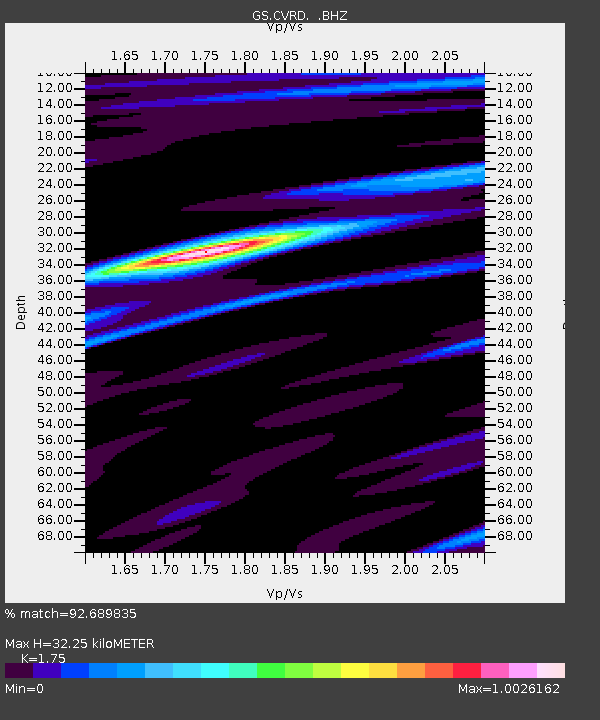
| Estimated Moho Depth: |
32.25 km |
| Estimated Crust Vp/Vs: |
1.75 |
| Assumed Crust Vp: |
6.419 km/s |
| Estimated Crust Vs: |
3.668 km/s |
| Estimated Crust Poisson's Ratio: |
0.26 |
|
| Radial Match: |
92.689835 % |
| Radial Bump: |
292 |
| Transverse Match: |
38.612213 % |
| Transverse Bump: |
400 |
| SOD ConfigId: |
458385 |
| Insert Time: |
2012-10-16 08:09:42.338 +0000 |
| GWidth: |
2.5 |
| Max Bumps: |
400 |
| Tol: |
0.001 |
|

Signal To Noise
| Channel | StoN | STA | LTA |
| GS:CVRD: :BHZ:20120604T00:51:19.314994Z | 11.681226 | 1.7052896E-6 | 1.459855E-7 |
| GS:CVRD: :BHN:20120604T00:51:19.314994Z | 8.763694 | 1.2235132E-6 | 1.3961159E-7 |
| GS:CVRD: :BHE:20120604T00:51:19.314994Z | 0.65633523 | 2.0531613E-7 | 3.1282204E-7 |
| Arrivals |
| Ps | 4.1 SECOND |
| PpPs | 13 SECOND |
| PsPs/PpSs | 17 SECOND |


