
Station GS CVRD - ???? Centerville Rd, Mineral, VA 23117 USA
Network: GS - US Geological Survey Networks
Nearby stations (2 deg radius)
| Station | Name | (Lat, Lon) | Start / End | Elevation |
| CVRD | ???? Centerville Rd, Mineral, VA 23117 USA | (38.07, -77.81) | 2011-08-26 / 2999-12-31 | 100 m |
| Crust2 Type: | Q2,orogen/39km no ice, Appalachians, North Andes, 0.5 km seds. |
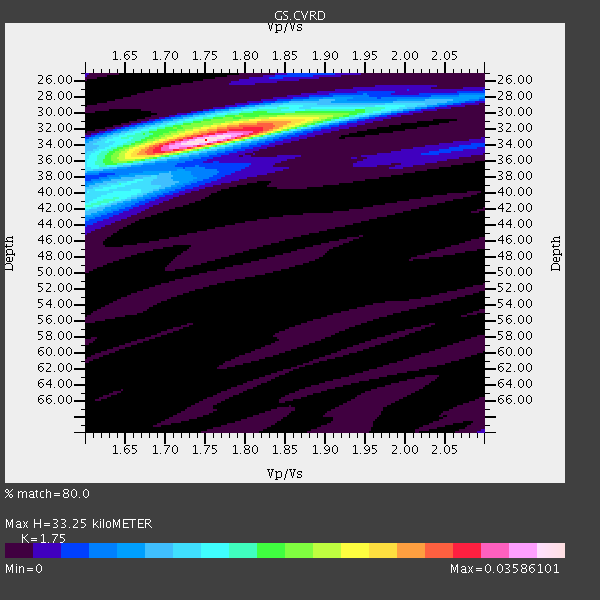
| Thickness Estimate: | 33 km |
| Thickness StdDev: | 1.7 km |
| Vp/Vs Estimate: | 1.75 |
| Vp/Vs StdDev: | 0.04 |
| Vs Estimate: | 3.668 km/s |
| Poisson's Ratio: | 0.26 |
| Peak Value: | 0.04 |
| Assumed Vp: | 6.419 km/s |
| Ps Weight: | 0.33333334 |
| PpPs Weight: | 0.33333334 |
| PsPs Weight: | 0.33333328 |
| Residual Complexity: | 0.486 |
| Nearby stations H: | +- |
| (2.0 deg) Vp/Vs: | +- |
5 with match > 90% ( 12.195122 %) and 9 with match > 80% ( 21.95122 %) out of 41.
Download stack as xyz text file.
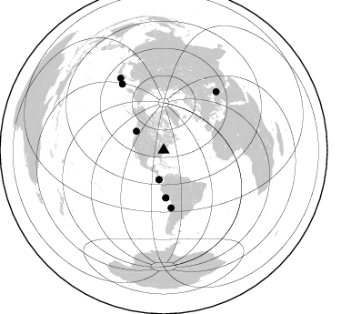
Azimuth Distribution of Events:
Prior Results for this Station
| Study | Thickness | Vp/Vs | Vp | Vs | Poissons Ratio | Extra |
| EARS | 33 km | 1.75 | 6.419 km/s | 3.668 km/s | 0.26 | |
| Crust2.0 | 39 km | 1.75 | 6.419 km/s | 3.659 km/s | 0.26 | Q2,orogen/39km no ice, Appalachians, North Andes, 0.5 km seds. |
| Global Maxima | 33 km | 1.75 | 6.419 km/s | 3.668 km/s | 0.26 | amp=0.03586101 |
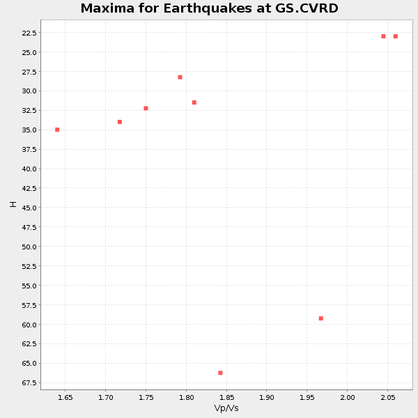
| Local Maxima 1 | 31 km | 1.82 | 6.419 km/s | 3.527 km/s | 0.28 | amp=0.018582458 |
| Local Maxima 2 | 41 km | 1.62 | 6.419 km/s | 3.956 km/s | 0.19 | amp=0.011827413 |
| Local Maxima 3 | 36 km | 1.65 | 6.419 km/s | 3.879 km/s | 0.21 | amp=0.008265842 |
| Local Maxima 4 | 32 km | 1.71 | 6.419 km/s | 3.754 km/s | 0.24 | amp=0.0069538555 |
| Predicted Arrivals for vertical incidence (zero ray parameter) | |
| Ps | 3.88 SECOND |
| PpPs | 14.24 SECOND |
| PsPs/PpSs | 18.13 SECOND |
Events Processed for this Station
Download zip of receiver functions as SAC
Plot maxima for each earthquake.
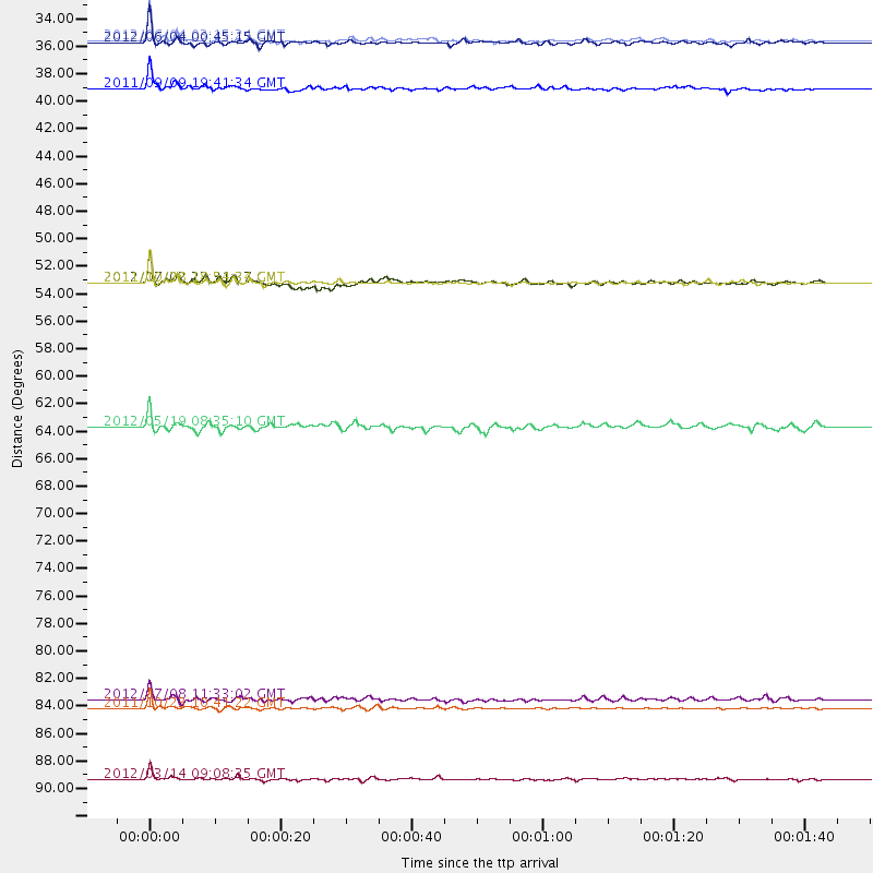
Events Used in the Stack
(9 events)| Radial Match | Distance | Baz | FERegion | Time | Lat/Lon | Depth | Magnitude |
| 97.46437 | 86.5 deg | 42.029 deg | Turkey | 2011/10/23 10:41:22 GMT | (38.7, 43.5) | 16 km | 6.9 MB, 7.3 MS, 7.3 MW, 7.1 MW |
| 97.20858 | 92.2 deg | 328.998 deg | Off East Coast Of Honshu, Japan | 2012/03/14 09:08:35 GMT | (40.9, 144.9) | 12 km | 6.7 MB, 6.9 MS, 6.9 MW, 7.0 MW |
| 96.2727 | 52.3 deg | 177.743 deg | Near Coast Of Peru | 2011/10/28 18:54:34 GMT | (-14.4, -76.0) | 24 km | 6.5 MB, 6.9 MS, 6.9 MW, 6.9 MW |
| 92.689835 | 32.9 deg | 188.861 deg | South Of Panama | 2012/06/04 00:45:15 GMT | (5.3, -82.6) | 7.0 km | 5.9 MB, 5.9 MS, 6.3 MW, 6.2 MW |
| 92.66416 | 36.6 deg | 304.374 deg | Vancouver Island, Canada Region | 2011/09/09 19:41:34 GMT | (49.5, -126.9) | 22 km | 6.3 MB, 6.4 MS, 6.4 MW, 6.5 MW |
| 89.24169 | 32.7 deg | 188.786 deg | South Of Panama | 2012/06/04 03:15:24 GMT | (5.5, -82.6) | 7.0 km | 5.8 MB, 5.8 MS, 6.3 MW, 6.1 MW |
| 86.299484 | 85.8 deg | 327.791 deg | Kuril Islands | 2012/07/08 11:33:02 GMT | (45.5, 151.3) | 20 km | 5.7 MB, 5.6 MS, 6.0 MW, 5.8 MW |
| 84.336586 | 52.3 deg | 177.292 deg | Near Coast Of Peru | 2012/07/02 23:31:37 GMT | (-14.4, -75.6) | 40 km | 6.0 MB, 5.2 MS, 5.7 MW, 5.6 MW |
| 80.38993 | 63.8 deg | 172.717 deg | Near Coast Of Northern Chile | 2012/05/19 08:35:10 GMT | (-25.7, -70.6) | 28 km | 5.7 MB, 5.5 MS, 5.8 MW, 5.9 MW |
Losers
(32 events)| Radial Match | Distance | Baz | FERegion | Time | Lat/Lon | Depth | Magnitude | Reason |
| 79.41871 | 93.2 deg | 43.382 deg | Iran-Iraq Border Region | 2012/05/03 10:09:35 GMT | (32.7, 47.7) | 10 km | 5.6 MB, 5.2 MW, 5.4 MW | |
| 74.63269 | 67.6 deg | 165.927 deg | Santiago Del Estero Prov., Arg. | 2011/09/02 13:47:09 GMT | (-28.4, -63.0) | 579 km | 6.4 MB, 6.7 MW, 6.7 MW | |
| 69.90141 | 67.2 deg | 165.904 deg | Santiago Del Estero Prov., Arg. | 2012/05/28 05:07:23 GMT | (-28.0, -63.1) | 587 km | 6.0 MB, 6.7 MW, 6.8 MW | |
| 68.70246 | 74.2 deg | 175.996 deg | Near Coast Of Central Chile | 2012/01/23 16:04:52 GMT | (-36.4, -73.0) | 20 km | 5.8 MB, 6.0 MS, 6.1 MW, 6.2 MW | |
| 66.96394 | 70.6 deg | 174.629 deg | Near Coast Of Central Chile | 2011/09/14 07:03:51 GMT | (-32.7, -71.8) | 37 km | 5.5 MS, 5.4 MB, 5.9 MW, 5.7 MW | |
| 65.32563 | 90.4 deg | 3.854 deg | Southwestern Siberia, Russia | 2012/02/26 06:17:19 GMT | (51.7, 96.0) | 12 km | 6.4 MB, 6.6 MS, 6.7 MW, 6.5 MW | |
| 65.00344 | 63.2 deg | 166.092 deg | Salta Province, Argentina | 2011/10/06 11:12:30 GMT | (-24.2, -64.2) | 15 km | 6.5 MB, 5.7 MS, 6.1 MW, 5.9 MW | |
| 61.76646 | 67.4 deg | 166.138 deg | Santiago Del Estero Prov., Arg. | 2012/03/05 07:46:10 GMT | (-28.2, -63.3) | 554 km | 6.0 MB, 6.1 MW, 6.1 MW | |
| 60.27792 | 63.3 deg | 316.529 deg | Fox Islands, Aleutian Islands | 2011/10/25 03:24:49 GMT | (52.2, -171.8) | 38 km | 5.9 MB, 5.3 MS, 5.7 MW, 5.7 MW | |
| 60.100056 | 70.5 deg | 322.852 deg | Near Islands, Aleutian Islands | 2011/09/14 18:10:09 GMT | (53.1, 173.0) | 15 km | 6.1 MB, 5.7 MS, 6.0 MW, 6.0 MW | |
| 57.704956 | 93.0 deg | 331.079 deg | Hokkaido, Japan Region | 2012/05/23 15:02:25 GMT | (41.3, 142.1) | 46 km | 6.2 MB, 5.5 MS, 5.9 MW, 6.0 MW | |
| 54.267185 | 52.0 deg | 177.325 deg | Near Coast Of Peru | 2012/01/30 05:11:00 GMT | (-14.2, -75.6) | 43 km | 6.3 MB, 5.9 MS, 6.4 MW, 6.4 MW | |
| 53.97974 | 86.0 deg | 38.269 deg | Eastern Caucasus | 2012/05/07 04:40:27 GMT | (41.5, 46.8) | 11 km | 5.7 MB, 5.7 MS, 5.6 MW, 5.6 MW | |
| 53.65452 | 71.0 deg | 323.593 deg | Near Islands, Aleutian Islands | 2012/06/19 15:56:32 GMT | (53.4, 171.6) | 14 km | 6.2 MB, 5.7 MS, 6.0 MW, 6.1 MW | |
| 53.074005 | 63.7 deg | 52.468 deg | Northern Italy | 2012/05/29 07:00:03 GMT | (44.9, 11.1) | 10 km | 5.9 MB, 5.8 MS, 5.8 MW, 5.8 MW | |
| 51.402863 | 61.3 deg | 164.906 deg | Salta Province, Argentina | 2012/06/02 07:52:53 GMT | (-22.1, -63.6) | 527 km | 5.8 MB, 5.9 MW, 6.0 MW | |
| 51.197136 | 52.2 deg | 21.766 deg | Norwegian Sea | 2012/05/24 22:47:46 GMT | (73.0, 5.7) | 10 km | 5.7 MB, 6.1 MS, 6.1 MW, 6.2 MW | |
| 50.42211 | 71.0 deg | 323.56 deg | Near Islands, Aleutian Islands | 2012/06/19 20:56:41 GMT | (53.4, 171.7) | 12 km | 5.9 MB, 5.2 MS, 5.6 MW, 5.7 MW | |
| 48.97503 | 71.6 deg | 325.493 deg | Komandorskiye Ostrova Region | 2012/05/29 02:40:53 GMT | (54.4, 168.9) | 10 km | 5.5 MS, 5.4 MB, 5.6 MW, 5.6 MW | |
| 48.628044 | 76.2 deg | 177.654 deg | Off Coast Of Central Chile | 2011/09/03 16:20:41 GMT | (-38.4, -74.9) | 12 km | 5.5 MB, 5.5 MS, 5.8 MW, 5.7 MW | |
| 48.221878 | 63.4 deg | 316.459 deg | Fox Islands, Aleutian Islands | 2011/09/19 08:14:14 GMT | (52.0, -172.0) | 31 km | 5.5 MB, 5.1 MS, 5.7 MW, 5.6 MW | |
| 48.120163 | 37.3 deg | 303.326 deg | Vancouver Island, Canada Region | 2012/02/04 20:05:31 GMT | (48.9, -127.9) | 15 km | 5.5 MB, 5.3 MS, 5.6 MW, 5.7 MW | |
| 47.986683 | 37.3 deg | 294.322 deg | Off Coast Of Oregon | 2011/10/13 04:14:00 GMT | (43.5, -127.1) | 21 km | 5.6 MW, 5.0 MS, 5.4 MB | |
| 47.527916 | 89.3 deg | 122.442 deg | South Atlantic Ocean | 2012/06/29 15:31:46 GMT | (-24.7, -9.7) | 10 km | 6.0 MB, 5.2 MS, 5.8 MW, 5.8 MW | |
| 46.371372 | 68.5 deg | 320.316 deg | Rat Islands, Aleutian Islands | 2011/10/31 07:16:21 GMT | (52.4, 177.9) | 159 km | 5.8 MB, 5.8 MW, 5.9 MW | |
| 41.35763 | 37.6 deg | 294.658 deg | Off Coast Of Oregon | 2012/02/15 03:31:20 GMT | (43.6, -127.5) | 11 km | 5.5 MB, 5.5 MS, 5.8 MW, 5.8 MW | |
| 33.898468 | 72.2 deg | 49.573 deg | Bulgaria | 2012/05/22 00:00:32 GMT | (42.6, 23.0) | 10 km | 5.7 MB, 5.3 MS, 5.6 MW, 5.5 MW | |
| 33.54759 | 56.0 deg | 170.538 deg | Peru-Bolivia Border Region | 2012/05/14 10:00:40 GMT | (-17.7, -69.6) | 106 km | 6.4 MB, 6.2 MW, 6.2 MW | |
| 32.942345 | 96.0 deg | 173.286 deg | Drake Passage | 2012/04/14 10:56:19 GMT | (-57.7, -65.3) | 15 km | 6.1 MB, 6.1 MS, 6.2 MW, 6.2 MW | |
| 31.211088 | 90.6 deg | 332.127 deg | Hokkaido, Japan Region | 2011/10/21 08:02:37 GMT | (43.9, 142.5) | 187 km | 5.9 MB, 6.1 MW, 6.1 MW | |
| 28.443745 | 39.7 deg | 185.852 deg | Off Coast Of Ecuador | 2011/11/17 01:57:05 GMT | (-1.7, -81.5) | 27 km | 5.7 MB, 5.6 MS, 6.0 MW, 5.9 MW | |
| 20.196032 | 65.9 deg | 173.322 deg | Near Coast Of Northern Chile | 2011/12/07 22:23:09 GMT | (-27.9, -70.9) | 20 km | 5.8 MB, 5.8 MS, 6.1 MW, 6.0 MW |
