You are here: Home > Network List > TA - USArray Transportable Network (new EarthScope stations) Stations List
> Station TASM ASL Pad, Albuquerque Seismic Lab, NM, USA > Earthquake Result Viewer
TASM ASL Pad, Albuquerque Seismic Lab, NM, USA - Earthquake Result Viewer
| Earthquake location: |
Near East Coast Of Honshu, Japan |
| Earthquake latitude/longitude: |
38.9/141.8 |
| Earthquake time(UTC): |
2012/06/17 (169) 20:32:20 GMT |
| Earthquake Depth: |
36 km |
| Earthquake Magnitude: |
6.0 MB, 5.9 MS, 6.3 MW, 6.4 MW |
| Earthquake Catalog/Contributor: |
WHDF/NEIC |
|
| Network: |
TA USArray Transportable Network (new EarthScope stations) |
| Station: |
TASM ASL Pad, Albuquerque Seismic Lab, NM, USA |
| Lat/Lon: |
34.95 N/106.46 W |
| Elevation: |
1862 m |
|
| Distance: |
83.1 deg |
| Az: |
50.243 deg |
| Baz: |
313.112 deg |
| Ray Param: |
0.046360478 |
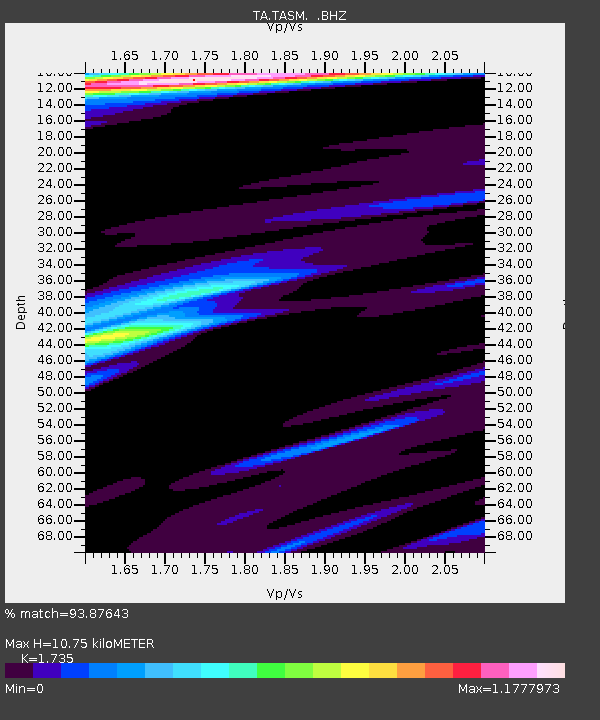
| Estimated Moho Depth: |
10.75 km |
| Estimated Crust Vp/Vs: |
1.74 |
| Assumed Crust Vp: |
6.502 km/s |
| Estimated Crust Vs: |
3.747 km/s |
| Estimated Crust Poisson's Ratio: |
0.25 |
|
| Radial Match: |
93.87643 % |
| Radial Bump: |
335 |
| Transverse Match: |
67.33936 % |
| Transverse Bump: |
400 |
| SOD ConfigId: |
460165 |
| Insert Time: |
2013-02-11 21:36:55.078 +0000 |
| GWidth: |
2.5 |
| Max Bumps: |
400 |
| Tol: |
0.001 |
|
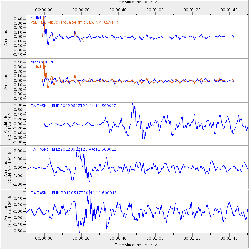
Signal To Noise
| Channel | StoN | STA | LTA |
| TA:TASM: :BHZ:20120617T20:44:11.60001Z | 5.49276 | 4.477843E-7 | 8.1522636E-8 |
| TA:TASM: :BHN:20120617T20:44:11.60001Z | 2.135818 | 9.716681E-8 | 4.5493955E-8 |
| TA:TASM: :BHE:20120617T20:44:11.60001Z | 2.2968585 | 1.17118695E-7 | 5.099082E-8 |
| Arrivals |
| Ps | 1.2 SECOND |
| PpPs | 4.4 SECOND |
| PsPs/PpSs | 5.7 SECOND |


