
Station TA TASM - ASL Pad, Albuquerque Seismic Lab, NM, USA
Network: TA - USArray Transportable Network (new EarthScope stations)
Nearby stations (2 deg radius)
| Station | Name | (Lat, Lon) | Start / End | Elevation |
| TASM | ASL Pad, Albuquerque Seismic Lab, NM, USA | (34.95, -106.46) | 2012-05-01 / 2599-12-31 | 1862 m |
| Crust2 Type: | X2,Rift, Rio Grande, Baikal, 0.5km sediments |
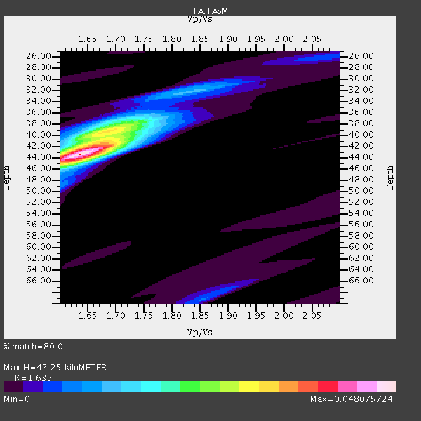
| Thickness Estimate: | 43 km |
| Thickness StdDev: | 1.1 km |
| Vp/Vs Estimate: | 1.63 |
| Vp/Vs StdDev: | 0.02 |
| Vs Estimate: | 3.976 km/s |
| Poisson's Ratio: | 0.20 |
| Peak Value: | 0.05 |
| Assumed Vp: | 6.502 km/s |
| Ps Weight: | 0.33333334 |
| PpPs Weight: | 0.33333334 |
| PsPs Weight: | 0.33333328 |
| Residual Complexity: | 0.569 |
| Nearby stations H: | 43 km +- 1.2 km |
| (2.0 deg) Vp/Vs: | 1.64 +- 0.01 |
10 with match > 90% ( 37.037037 %) and 14 with match > 80% ( 51.851852 %) out of 27.
Download stack as xyz text file.
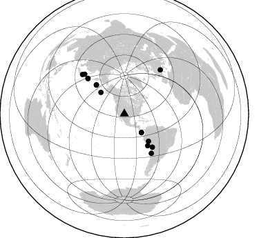
Azimuth Distribution of Events:
Prior Results for this Station
| Study | Thickness | Vp/Vs | Vp | Vs | Poissons Ratio | Extra |
| EARS | 43 km | 1.63 | 6.502 km/s | 3.976 km/s | 0.20 | |
| Crust2.0 | 33 km | 1.77 | 6.502 km/s | 3.68 km/s | 0.26 | X2,Rift, Rio Grande, Baikal, 0.5km sediments |
| Global Maxima | 43 km | 1.63 | 6.502 km/s | 3.976 km/s | 0.20 | amp=0.048075724 |
| Local Maxima 1 | 39 km | 1.69 | 6.502 km/s | 3.847 km/s | 0.23 | amp=0.026129294 |
| Local Maxima 2 | 41 km | 1.69 | 6.502 km/s | 3.858 km/s | 0.23 | amp=0.01956896 |
| Local Maxima 3 | 32 km | 1.83 | 6.502 km/s | 3.548 km/s | 0.29 | amp=0.010559482 |
| Local Maxima 4 | 69 km | 1.86 | 6.502 km/s | 3.505 km/s | 0.30 | amp=0.0073244185 |
| Predicted Arrivals for vertical incidence (zero ray parameter) | |
| Ps | 4.22 SECOND |
| PpPs | 17.53 SECOND |
| PsPs/PpSs | 21.75 SECOND |
Events Processed for this Station
Download zip of receiver functions as SAC
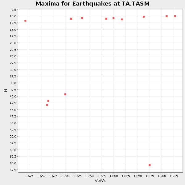
Plot maxima for each earthquake.
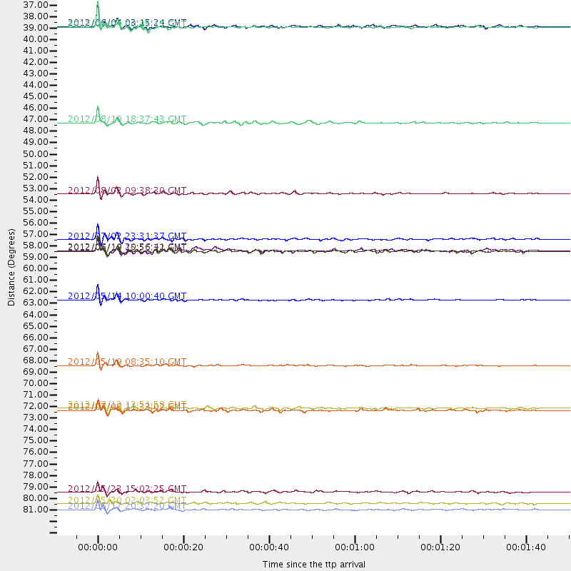
Events Used in the Stack
(14 events)| Radial Match | Distance | Baz | FERegion | Time | Lat/Lon | Depth | Magnitude |
| 96.56644 | 46.0 deg | 312.165 deg | Fox Islands, Aleutian Islands | 2012/08/10 18:37:43 GMT | (52.6, -167.4) | 13 km | 5.9 MB, 6.2 MS, 6.2 MW, 6.2 MW |
| 96.24202 | 63.0 deg | 140.048 deg | Peru-Bolivia Border Region | 2012/05/14 10:00:40 GMT | (-17.7, -69.6) | 106 km | 6.4 MB, 6.2 MW, 6.2 MW |
| 95.233284 | 52.8 deg | 138.542 deg | Peru-Brazil Border Region | 2012/08/02 09:38:30 GMT | (-8.4, -74.3) | 145 km | 5.9 MB, 6.1 MW, 6.1 MW |
| 94.08419 | 36.8 deg | 137.815 deg | South Of Panama | 2012/06/04 00:45:15 GMT | (5.3, -82.6) | 7.0 km | 5.9 MB, 5.9 MS, 6.3 MW, 6.2 MW |
| 94.07008 | 58.3 deg | 315.759 deg | Near Islands, Aleutian Islands | 2012/06/19 15:56:32 GMT | (53.4, 171.6) | 14 km | 6.2 MB, 5.7 MS, 6.0 MW, 6.1 MW |
| 93.87643 | 83.1 deg | 313.112 deg | Near East Coast Of Honshu, Japan | 2012/06/17 20:32:20 GMT | (38.9, 141.8) | 36 km | 6.0 MB, 5.9 MS, 6.3 MW, 6.4 MW |
| 93.46658 | 81.4 deg | 314.866 deg | Hokkaido, Japan Region | 2012/05/23 15:02:25 GMT | (41.3, 142.1) | 46 km | 6.2 MB, 5.5 MS, 5.9 MW, 6.0 MW |
| 93.41734 | 69.3 deg | 145.562 deg | Near Coast Of Northern Chile | 2012/05/19 08:35:10 GMT | (-25.7, -70.6) | 28 km | 5.7 MB, 5.5 MS, 5.8 MW, 5.9 MW |
| 92.92496 | 57.2 deg | 143.739 deg | Near Coast Of Peru | 2012/07/02 23:31:37 GMT | (-14.4, -75.6) | 40 km | 6.0 MB, 5.2 MS, 5.7 MW, 5.6 MW |
| 92.82928 | 36.7 deg | 137.536 deg | South Of Panama | 2012/06/04 03:15:24 GMT | (5.5, -82.6) | 7.0 km | 5.8 MB, 5.8 MS, 6.3 MW, 6.1 MW |
| 84.88347 | 73.6 deg | 314.229 deg | Kuril Islands | 2012/07/08 11:33:02 GMT | (45.5, 151.3) | 20 km | 5.7 MB, 5.6 MS, 6.0 MW, 5.8 MW |
| 84.54129 | 73.4 deg | 314.039 deg | Kuril Islands | 2012/07/12 12:51:58 GMT | (45.5, 151.7) | 12 km | 5.5 MB, 5.6 MS, 5.8 MW, 5.7 MW |
| 83.17777 | 58.2 deg | 315.742 deg | Near Islands, Aleutian Islands | 2012/06/19 20:56:41 GMT | (53.4, 171.7) | 12 km | 5.9 MB, 5.2 MS, 5.6 MW, 5.7 MW |
| 80.81834 | 82.5 deg | 39.404 deg | Northern Italy | 2012/05/20 02:03:52 GMT | (44.9, 11.2) | 6.3 km | 5.8 MB, 6.0 MS, 6.0 MW, 6.1 MW |
Losers
(13 events)| Radial Match | Distance | Baz | FERegion | Time | Lat/Lon | Depth | Magnitude | Reason |
| 78.33693 | 95.2 deg | 255.869 deg | Vanuatu Islands | 2012/07/06 02:28:22 GMT | (-14.7, 167.3) | 160 km | 5.7 MB, 6.3 MW, 6.3 MW | |
| 75.79051 | 69.8 deg | 137.706 deg | Salta Province, Argentina | 2012/06/02 07:52:53 GMT | (-22.1, -63.6) | 527 km | 5.8 MB, 5.9 MW, 6.0 MW | |
| 75.03634 | 73.5 deg | 314.091 deg | Kuril Islands | 2012/07/11 02:31:16 GMT | (45.4, 151.4) | 10 km | 5.6 MB, 5.5 MS, 5.7 MW, 5.7 MW | |
| 71.47121 | 63.6 deg | 186.007 deg | Easter Island Region | 2012/05/10 02:13:56 GMT | (-28.7, -112.6) | 10 km | 5.8 MS, 5.3 MB, 5.9 MW, 5.8 MW | |
| 67.03359 | 88.0 deg | 242.896 deg | Fiji Islands Region | 2012/07/18 08:09:46 GMT | (-20.9, -178.5) | 537 km | 5.5 MB, 5.9 MW, 6.0 MW | |
| 64.86006 | 68.8 deg | 315.92 deg | Kuril Islands | 2012/07/20 06:32:56 GMT | (49.4, 156.1) | 10 km | 5.8 MB, 5.5 MS, 5.8 MW, 5.9 MW | |
| 63.743027 | 85.6 deg | 242.103 deg | Tonga Islands | 2012/05/28 21:47:09 GMT | (-20.0, -176.0) | 211 km | 5.9 MW, 5.3 MB, 5.9 MW | |
| 58.81606 | 90.0 deg | 34.744 deg | Bulgaria | 2012/05/22 00:00:32 GMT | (42.6, 23.0) | 10 km | 5.7 MB, 5.3 MS, 5.6 MW, 5.5 MW | |
| 57.875034 | 89.6 deg | 242.551 deg | South Of Fiji Islands | 2012/05/29 03:33:25 GMT | (-22.1, -179.6) | 602 km | 5.6 MB, 5.8 MW, 5.9 MW | |
| 55.206673 | 96.3 deg | 261.252 deg | Solomon Islands | 2012/07/03 03:49:33 GMT | (-10.8, 163.3) | 92 km | 5.6 MB, 5.5 MW, 5.5 MW | |
| 52.252514 | 83.5 deg | 312.739 deg | Near East Coast Of Honshu, Japan | 2012/08/29 19:05:11 GMT | (38.4, 141.8) | 47 km | 5.8 MB, 5.1 MS, 5.5 MW, 5.5 MW | |
| 50.43471 | 79.2 deg | 320.973 deg | Primor'ye, Russia | 2012/07/29 09:20:54 GMT | (47.4, 139.1) | 502 km | 5.6 MB, 5.6 MW, 5.7 MW | |
| 48.878807 | 88.8 deg | 243.075 deg | Fiji Islands Region | 2012/07/20 14:03:13 GMT | (-21.2, -179.3) | 625 km | 5.6 MB, 5.6 MW, 5.5 MW |
