You are here: Home > Network List > TA - USArray Transportable Network (new EarthScope stations) Stations List
> Station TASM ASL Pad, Albuquerque Seismic Lab, NM, USA > Earthquake Result Viewer
TASM ASL Pad, Albuquerque Seismic Lab, NM, USA - Earthquake Result Viewer

| Earthquake location: |
Near Islands, Aleutian Islands |
| Earthquake latitude/longitude: |
53.4/171.6 |
| Earthquake time(UTC): |
2012/06/19 (171) 15:56:32 GMT |
| Earthquake Depth: |
14 km |
| Earthquake Magnitude: |
6.2 MB, 5.7 MS, 6.0 MW, 6.1 MW |
| Earthquake Catalog/Contributor: |
WHDF/NEIC |
|
| Network: |
TA USArray Transportable Network (new EarthScope stations) |
| Station: |
TASM ASL Pad, Albuquerque Seismic Lab, NM, USA |
| Lat/Lon: |
34.95 N/106.46 W |
| Elevation: |
1862 m |
|
| Distance: |
58.3 deg |
| Az: |
72.951 deg |
| Baz: |
315.759 deg |
| Ray Param: |
0.06293079 |
| Estimated Moho Depth: |
43.25 km |
| Estimated Crust Vp/Vs: |
1.66 |
| Assumed Crust Vp: |
6.502 km/s |
| Estimated Crust Vs: |
3.911 km/s |
| Estimated Crust Poisson's Ratio: |
0.22 |
|
| Radial Match: |
94.07008 % |
| Radial Bump: |
398 |
| Transverse Match: |
78.227585 % |
| Transverse Bump: |
400 |
| SOD ConfigId: |
460165 |
| Insert Time: |
2013-02-11 22:35:40.396 +0000 |
| GWidth: |
2.5 |
| Max Bumps: |
400 |
| Tol: |
0.001 |
|
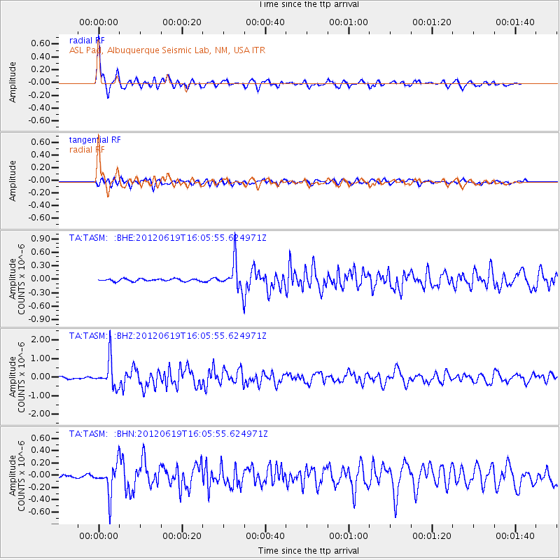
Signal To Noise
| Channel | StoN | STA | LTA |
| TA:TASM: :BHZ:20120619T16:05:55.624971Z | 15.378881 | 7.780869E-7 | 5.0594505E-8 |
| TA:TASM: :BHN:20120619T16:05:55.624971Z | 7.9958515 | 2.5189138E-7 | 3.1502758E-8 |
| TA:TASM: :BHE:20120619T16:05:55.624971Z | 12.5713215 | 3.3870765E-7 | 2.6942883E-8 |
| Arrivals |
| Ps | 4.6 SECOND |
| PpPs | 17 SECOND |
| PsPs/PpSs | 21 SECOND |


