You are here: Home > Network List > TA - USArray Transportable Network (new EarthScope stations) Stations List
> Station TASL Snake Pit, Albuquerque Seismic Lab, NM, USA > Earthquake Result Viewer
TASL Snake Pit, Albuquerque Seismic Lab, NM, USA - Earthquake Result Viewer
| Earthquake location: |
Near Islands, Aleutian Islands |
| Earthquake latitude/longitude: |
53.4/171.7 |
| Earthquake time(UTC): |
2012/06/19 (171) 20:56:41 GMT |
| Earthquake Depth: |
12 km |
| Earthquake Magnitude: |
5.9 MB, 5.2 MS, 5.6 MW, 5.7 MW |
| Earthquake Catalog/Contributor: |
WHDF/NEIC |
|
| Network: |
TA USArray Transportable Network (new EarthScope stations) |
| Station: |
TASL Snake Pit, Albuquerque Seismic Lab, NM, USA |
| Lat/Lon: |
34.95 N/106.46 W |
| Elevation: |
1838 m |
|
| Distance: |
58.2 deg |
| Az: |
73.005 deg |
| Baz: |
315.742 deg |
| Ray Param: |
0.06296492 |
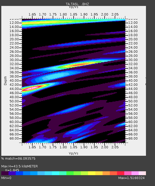
| Estimated Moho Depth: |
43.5 km |
| Estimated Crust Vp/Vs: |
1.64 |
| Assumed Crust Vp: |
6.502 km/s |
| Estimated Crust Vs: |
3.952 km/s |
| Estimated Crust Poisson's Ratio: |
0.21 |
|
| Radial Match: |
86.093575 % |
| Radial Bump: |
400 |
| Transverse Match: |
65.51106 % |
| Transverse Bump: |
400 |
| SOD ConfigId: |
460165 |
| Insert Time: |
2013-02-11 23:32:59.352 +0000 |
| GWidth: |
2.5 |
| Max Bumps: |
400 |
| Tol: |
0.001 |
|

Signal To Noise
| Channel | StoN | STA | LTA |
| TA:TASL: :BHZ:20120619T21:06:04.52498Z | 7.5549784 | 3.8582343E-7 | 5.1068767E-8 |
| TA:TASL: :BHN:20120619T21:06:04.52498Z | 2.6575882 | 1.3354355E-7 | 5.0249902E-8 |
| TA:TASL: :BHE:20120619T21:06:04.52498Z | 3.5455344 | 1.874013E-7 | 5.2855587E-8 |
| Arrivals |
| Ps | 4.6 SECOND |
| PpPs | 17 SECOND |
| PsPs/PpSs | 21 SECOND |


