You are here: Home > Network List > IC - New China Digital Seismograph Network Stations List
> Station HIA Hailar, Neimenggu Province, China > Earthquake Result Viewer
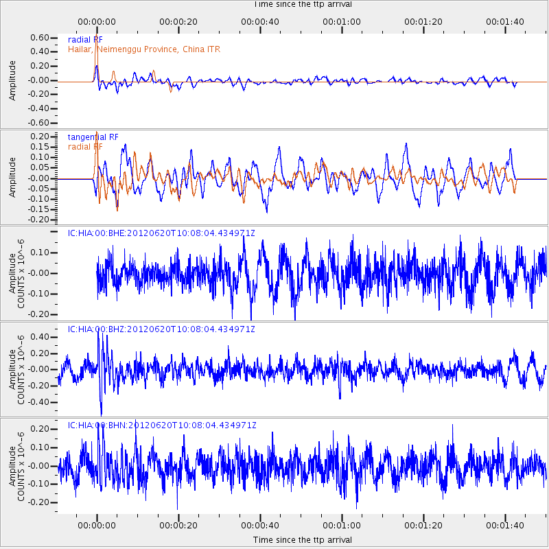
HIA Hailar, Neimenggu Province, China - Earthquake Result Viewer
*The percent match for this event was below the threshold and hence no stack was calculated.
| Earthquake location: |
Southern Sumatra, Indonesia |
| Earthquake latitude/longitude: |
-4.9/103.2 |
| Earthquake time(UTC): |
2012/06/20 (172) 09:59:04 GMT |
| Earthquake Depth: |
70 km |
| Earthquake Magnitude: |
5.6 MB, 5.2 MW, 5.3 MW |
| Earthquake Catalog/Contributor: |
WHDF/NEIC |
|
| Network: |
IC New China Digital Seismograph Network |
| Station: |
HIA Hailar, Neimenggu Province, China |
| Lat/Lon: |
49.27 N/119.74 E |
| Elevation: |
620 m |
|
| Distance: |
55.9 deg |
| Az: |
13.025 deg |
| Baz: |
200.049 deg |
| Ray Param: |
$rayparam |
*The percent match for this event was below the threshold and hence was not used in the summary stack. |
|
| Radial Match: |
48.79078 % |
| Radial Bump: |
400 |
| Transverse Match: |
71.83494 % |
| Transverse Bump: |
400 |
| SOD ConfigId: |
460165 |
| Insert Time: |
2013-02-11 23:47:23.787 +0000 |
| GWidth: |
2.5 |
| Max Bumps: |
400 |
| Tol: |
0.001 |
|
Signal To Noise
| Channel | StoN | STA | LTA |
| IC:HIA:00:BHZ:20120620T10:08:04.434971Z | 2.5386896 | 2.2679734E-7 | 8.933638E-8 |
| IC:HIA:00:BHN:20120620T10:08:04.434971Z | 1.821995 | 9.4382486E-8 | 5.1801727E-8 |
| IC:HIA:00:BHE:20120620T10:08:04.434971Z | 1.3832387 | 6.479428E-8 | 4.684244E-8 |
| Arrivals |
| Ps | |
| PpPs | |
| PsPs/PpSs | |


