You are here: Home > Network List > GS - US Geological Survey Networks Stations List
> Station CVRD ???? Centerville Rd, Mineral, VA 23117 USA > Earthquake Result Viewer
CVRD ???? Centerville Rd, Mineral, VA 23117 USA - Earthquake Result Viewer
| Earthquake location: |
Near Coast Of Peru |
| Earthquake latitude/longitude: |
-14.4/-75.6 |
| Earthquake time(UTC): |
2012/07/02 (184) 23:31:37 GMT |
| Earthquake Depth: |
40 km |
| Earthquake Magnitude: |
6.0 MB, 5.2 MS, 5.7 MW, 5.6 MW |
| Earthquake Catalog/Contributor: |
WHDF/NEIC |
|
| Network: |
GS US Geological Survey Networks |
| Station: |
CVRD ???? Centerville Rd, Mineral, VA 23117 USA |
| Lat/Lon: |
38.07 N/77.81 W |
| Elevation: |
100 m |
|
| Distance: |
52.3 deg |
| Az: |
357.794 deg |
| Baz: |
177.292 deg |
| Ray Param: |
0.06679367 |
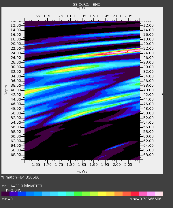
| Estimated Moho Depth: |
23.0 km |
| Estimated Crust Vp/Vs: |
2.05 |
| Assumed Crust Vp: |
6.419 km/s |
| Estimated Crust Vs: |
3.139 km/s |
| Estimated Crust Poisson's Ratio: |
0.34 |
|
| Radial Match: |
84.336586 % |
| Radial Bump: |
400 |
| Transverse Match: |
55.075226 % |
| Transverse Bump: |
400 |
| SOD ConfigId: |
463687 |
| Insert Time: |
2013-02-20 17:52:29.436 +0000 |
| GWidth: |
2.5 |
| Max Bumps: |
400 |
| Tol: |
0.001 |
|

Signal To Noise
| Channel | StoN | STA | LTA |
| GS:CVRD: :BHZ:20120702T23:40:14.589993Z | 6.809189 | 6.2826194E-7 | 9.226679E-8 |
| GS:CVRD: :BHN:20120702T23:40:14.589993Z | 3.284791 | 4.1040167E-7 | 1.2493996E-7 |
| GS:CVRD: :BHE:20120702T23:40:14.589993Z | 0.7616353 | 1.15517985E-7 | 1.51671E-7 |
| Arrivals |
| Ps | 3.9 SECOND |
| PpPs | 10 SECOND |
| PsPs/PpSs | 14 SECOND |


